mail_outline sales@mediastorehouse.com
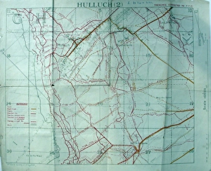
Trench maps belonging to Sergeant Ernest BlaikleyTrench maps belonging to 2903 Sergeant ERNEST BLAIKLEY, 28th Battalion London Regiment (Artists Rifles) (1885-1965). Attached S.O. & S
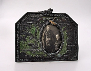
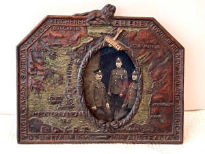
WWI photo frame showing the Eastern FrontFirst World War photo frame showing the Eastern Front with names of Generals and Allied Powers (1914-18) around the edge. Includes maps of Bulgaria, Greece, Asia Minor, Syria and Egypt.. Trench Art
Eastern Front photo frame, WW1First World War photo frame showing the Eastern Front with names of Generals and Allied Powers (1914-1918) around the edge. Includes maps of Bulgaria, Greece, Asia Minor, Syria and Egypt. Trench Art
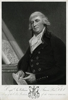
Capt Sir William Fraser, Bar F.R.S, (d.1818), one of the Elder Brethren of Trinity House, (1737 - 1818) on left a rolled chart of Papua New Guinea
Scouts in London for the CoronationBoy Scouts and Sea Scouts with maps in Westminster, Central London, at the time of the Coronation of Queen Elizabeth II on 2 June 1953. Date: 1953
Map with clocks at Baden Powell House, LondonA modern map with clocks showing the time in different parts of the globe at Baden Powell House, South Kensington, London. Above it are the words: From All Corners of the Earth You Have Journeyed
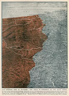
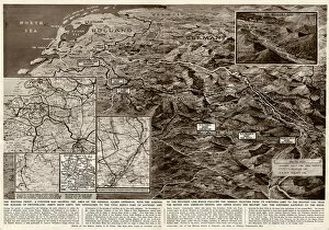
The Fighting Line in Flanders, 1915Areas of possession between the German and Allied armies on the Western front by the autumn of 1915. Despite the advances made by the Germans at Ypres
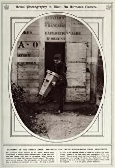
An airmans camera 1917Efficiency in the French Army: Apparatus for taking photographs from an aeroplanes. The French Armys camera takes aerial photographs of the enemies trenches, they are developed and put on maps
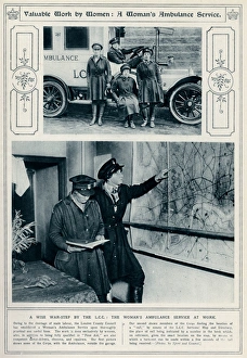
Womens home front ambulance service 1917Owing to the shorage of male labour, the London County Council established a Womens ambulance service, quailfied in first aid and competent motor drivers
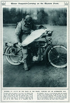
Winter dispatch carrying on the Western Front 1917Corporal Newsham, a British Press despatch rider, studying a map on his motorcycle at Rollancourt in northern France during the First World War
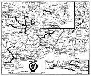
British roads damaged by military traffic, WW1A map of the Southern counties of Britain prepared by the Automobile Association and the Motor Union to indicate the stretches of road extensively damaged by the passage of military traffic
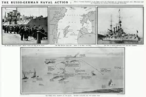
Russo-German naval action in the Baltic, WW1Russo-German naval action in the Baltic during the First World War which led to the destruction of a German destroyer and mine layer and the torpedoing of a German pre-dreadnought battleship
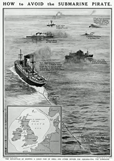
How to avoid the submarine pirate by G. H. DavisHow to avoid the submarine pirate during the First World War. The advantage of showing a clean pair of heels and other devices for checkmating the submarine. Date: 1915
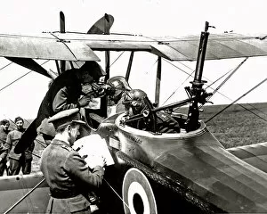
RAF personnel marking German positions, WW1RAF pilots and observers marking German positions in preparation for a raid, on the Western Front in France during World War One. Date: circa 1918
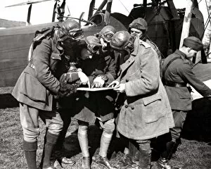
Pilot and observer about to set out, Western Front, WW1A British pilot and his observer getting instructions through their CO via photographs and maps before setting out for the German lines on the Western Front in France during World War One
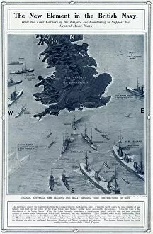
New element in British Navy by G. H. DavisThe new element in the British Navy: how the four corners of the Empire are combining to support the central Home Navy. Showing how Canada, Australia
Contour map of Western Front by G. H. DavisThe Western Front: a contour map showing the area of the general Allied offensive at this stage of the Second World War. Showing the Siegfried Line, the supply port of Antwerp
Men in basket of observation balloon, WW1Two men with telephones and maps in the basket of an RFA observation balloon on the Western Front in France during World War One. Date: circa 1916
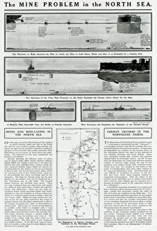
Mine problem in North Sea by G. H. DavisThe mine problem in the North Sea. The mine layer at work, showing the way in which the mine is held below the water and how it is exploded by a passing ship
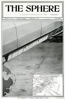
Zeppelin airship flights by night, by G. H. DavisThe possibilities of Zeppelin airship flights by night. Showing a 360 mile route from Heligoland to Selby, and an inset map with various routes marked
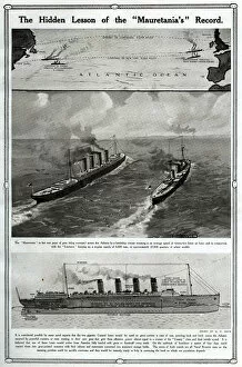
Hidden lesson of the Mauretanias record by G. H. DavisThe hidden lesson of the Mauretanias record. Showing the Cunard liner Mauretania in grey war paint, being convoyed across the Atlantic by a battleship cruiser
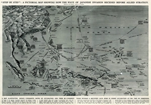
Map of Japanese invasion receding by G. H. DavisA pictorial map of the Pacific area, showing how the wave of Japanese invasion receded as a result of the Allied strategy during the Second World War
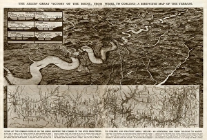
Allies victory of the Rhine by G. H. DavisThe Allies victory of the Rhine during the Second World War: from Wesel to Coblenz. A birds eye map of the terrain, with an additional map from Cologne to Mainz. Date: 1945
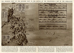
Battle of the Philippines by G. H. DavisThe crushing rout of the Japanese Navy in the Battle of the Philippines during the Second World War. A map of the operations
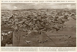
Allied landings in southern France by G. H. DavisThe scene of successful Allied landings in southern France during the Second World War: a pictorial map from coasts to mountains. Date: 1944
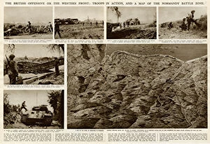
British offensive on Western Front by G. H. DavisThe British offensive on the Western Front during the Second World War: troops in action, and a map of the Normandy battle zone. Date: 1944
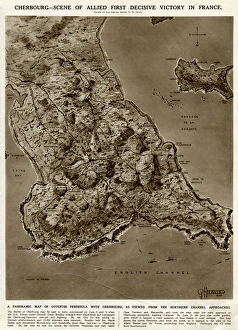
Cherbourg, scene of victory, by G. H. DavisCherbourg -- scene of Allied first decisive victory in France during the Second World War. A panoramic map of Cotentin Peninsula with Cherbourg, as viewed from the northern Channel approaches
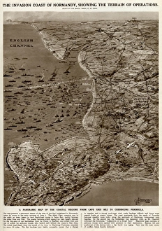
Invasion coast of Normandy by G. H. DavisThe invasion coast of Normandy, showing the terrain of operations during the Second World War. A panoramic map of the coastal regions from Cap Gris Nez to the Cherbourg Peninsula. Date: 1944
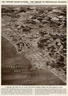
Onward roads to Rome by G. H. DavisThe onward roads to Rome: the terrain of spectacular advances during the Second World War. A panoramic map from the Liri Valley and Pontine Marshes, showing the main highways to Rome. Date: 1944
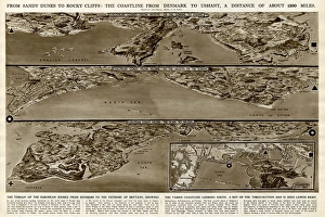
Coastline from Denmark to Ushant by G. H. DavisFrom sandy dunes to rocky cliffs: the coastline from Denmark to Ushant (Brittany), a distance of about 1200 miles. The terrain of the European shores from Denmark to the extreme of Brittany
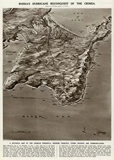
Map of the Crimean peninsula by G. H. DavisRussias reconquest of the Crimea during the Second World War. A pictorial map of the Crimean peninsula, showing principal towns, heights and communications. Date: 1944
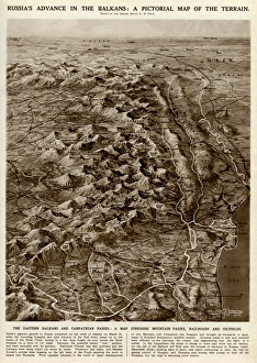
Russian advance in Balkans by G. H. DavisRussias advance in the Balkans during the Second World War: a pictorial map of the terrain. The Eastern Balkans and Carpathian passes: a map showing mountain passes, railways and oilfields. Date: 1944
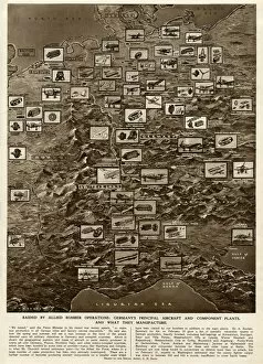
German plants raided by Allied bombing, by G. H. DavisRaided by Allied bomber operations during the Second World War: Germanys principal aircraft and component plants, and what they manufacture. Date: 1944
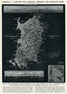
Map of Sardinia by G. H. DavisA contour map of Sardinia, showing airfields and seaplane bases during the Second World War. The island was experiencing concentrated bombing by the Allied Strategic Air Force. Date: 1943
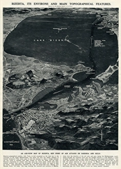
Bizerta and environs by G. H. DavisBizerta (Bizerte, Tunisia, North Africa), its environs and main topographical features. An air-view map of Bizerta, key point of air attacks on Sardinia and Sicily during the Second World War
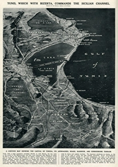
Tunis commanding Sicilian Channel by G. H. DavisTunis, which with Bizerta commands the Sicilian Channel. A contour map showing the capital of Tunisia, its approaches, roads, harbour and surrounding terrain
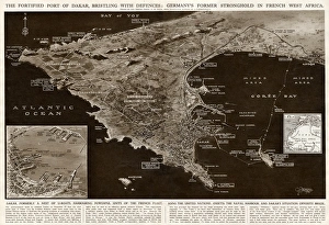
Fortified port of Dakar by G. H. DavisThe fortified port of Dakar, French West Africa, bristling with defences during the Second World War. It was formerly a German stronghold, full of U-boats. Date: 1942
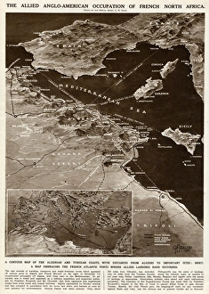
Allied occupation of French North Africa by G. H. DavisThe Allied Anglo-American occupation of French North Africa during the Second World War. A contour map of the Algerian and Tunisian coasts, with distances from Algiers to important sites
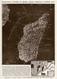
Madagascar strategic island by G. H. DavisMadagascar, the strategic island to Allied communications in the East, occupied by British forces, forestalls a Japanese plot during the Second World War
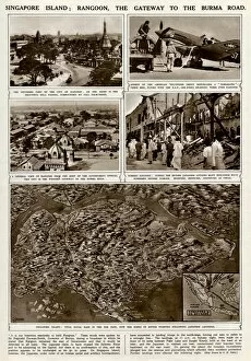
Singapore island, vital naval base, by G. H. DavisSingapore island: Rangoon, the gateway to the Burma Road during the Second World War. The island was a vital Allied naval base in the Far East
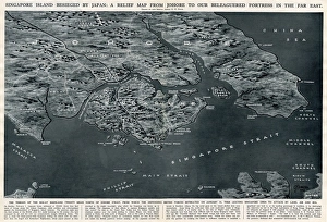
Singapore besieged by Japan, by G. H. DavisSingapore island besieged by Japan during the Second World War: a relief map from Johore to the beleaguered fortress in the Far East where the defending British forces retreated on 31 January 1942
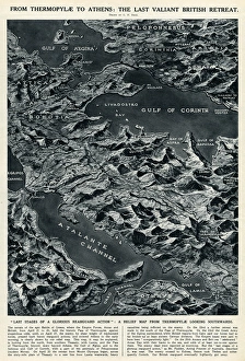
British retreat from Thermopylae to Athens by G. H. DavisFrom Thermopylae to Athens: the last valiant British retreat. A relief map looking southwards, showing the last stages of a glorious rearguard action during the Battle of Greece, Second World War
Aerial map-making by G. H. DavisA revolution in aerial map making during the Second World War: perspective maps for airmen. Used as an aid to air navigators and air bombers in precision bombing. Date: 1943
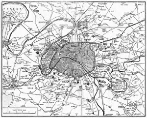
The War: Fortifications in ParisMap showing the fortifications in Paris during the Franco-Prussian War. Date: 1870
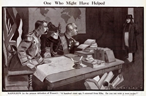
Cartoon, One Who Might Have Helped, WW1Cartoon, One Who Might Have Helped. Showing Lord Kitchener and General Pau, defenders of France at the start of the First World War, sitting at a desk with books and maps
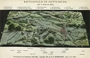
The Battlefield of Gettysburg. Photograph from Huidekopers relief map of the battlefield. As it was in 1863. Date: 1901
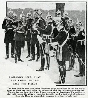
Kaiser Wilhelm with his generals, WW1Kaiser Wilhelm II of Germany giving directions to his generals at the start of the First World War. Date: 1914
Map of the Belgian frontier with forts, World War OneMap of the Belgian frontier with forts at the beginning of World War One. Date: 1914