mail_outline sales@mediastorehouse.com
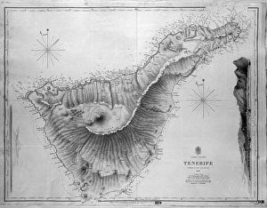
Map of Tenerife, Canary Islands, with soundings in fathoms. Date: 1838
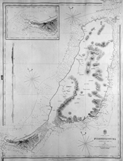
Map of Fuerteventura, Canary Islands, with soundings in fathoms. Date: 1835
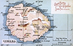
Map of La Gomera, Canary Islands. Date: circa 1908
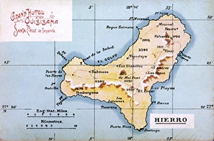
Map of Hierro, Canary Islands. Date: circa 1908
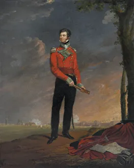
Major (later Major-General) Sir Neil Campbell CB (1776-1827), 1815 (c).Oil on canvas by Edouard Henri Pingret (1788-1875), 1819.Full-length
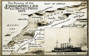
Map of Dardanelles with HMS Bacchante, WW1Map of the Dardanelles with an inset image of HMS Bacchante, British Cressy-class armoured cruiser. 1915
Map of YorkshireA map of Yorkshire, from the mid 18th century. Date: Mid 18th century
Map of LancashireA map of Lancashire, from the mid 18th century. Date: Mid 18th century
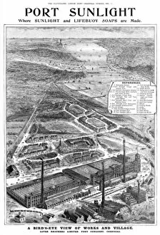
Port Sunlight - aerial mapSuperb aerial view of Port Sunlight, the factory and home of Sunlight and Lifebuoy soaps, together with the model village built on the Wirral by William Lever for the benefit of his workers
Paris, France - Eglise de Saint Gervais et Saint Protais Date: 1855
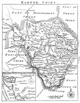
Map of Radnorshire, Wales, 18th centuryMap of Radnorshire in Wales, mid-18th century, with towns marked including Rhyadergowy, Knighton, Presteign and Hay-on-Wye. Date: Mid-18th Century
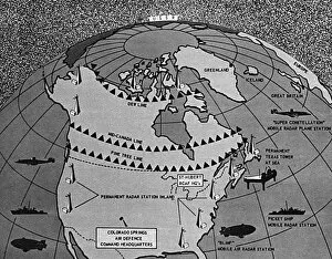
Map showing distant early warning line for defenceDistant early warning line (DEW line) of all-round radar defence. A map of North America, showing the various systems and devices of Conad
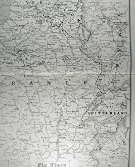
Times War Atlas - WWI mapsThe Times War Atlas. The atlas contains the following loose maps - 1) Map of the North Sea. 2) Map of the frontiers of France. 3) Map of the North Eastern Theatre of War. 4) Map of the Balkans
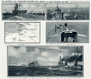
Battle of the Falkland Islands by G. H. DavisThe Battle of the Falkland Islands -- how Admiral von Spees squadron was sunk, the German cruiser Dresden alone escaping. Showing the action between the German cruiser Leipzig
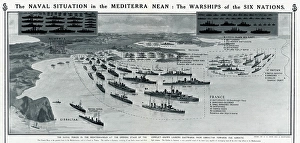
Warships of the six nations in the Mediterranean, WW1The naval situation in the Mediterranean: the warships of the six nations (Britain, France, Russia, Germany, Italy and Austria). Shown looking eastwards from Gibraltar towards the Adriatic. Date: 1914
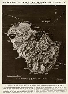
Map of Pantellaria (Pantelleria) by G. H. DavisA contour map of Pantellaria (Pantelleria), a volcanic Italian island outpost which surrendered unconditionally on 11 June 1943 -- the first loss of Italian soil to the Allies during the Second World
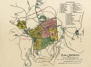
The Plan of Jerusalem. Town map layout showing the location of the American Colony Stores. Date: C. 1910
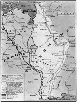
Map of Germany, Belgium, France illustrating ArmisticeA map illustrating the Armistice at the end of World War One. The black line shows the battle line on Armistice Day, 11th November 1918
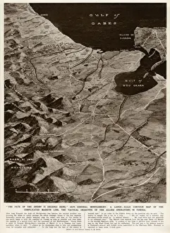
Mareth Line, Tunisia, by G. H. DavisA large-scale contour map of the complicated Mareth Line in Tunisia, North Africa, where General Montgomery stated that the enemys fate would be decided
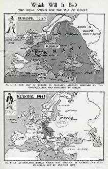
Two rival designs for the Map of Europe, WW1Two rival designs for the Map of Europe at the start of the First World War. Above: a new map as probably already designed by the Hohenzollern map specialist in Berlin
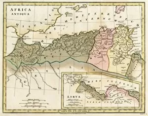
Map of Northern Africa. Date: 1807
The Invincible Armada. Map of Robert Adams. Engraving" The Invincible Armada. Map of Robert Adams. Engraving by Augustine Ryther in " Expeditions in Anglian, Vera Descriptio" (1588). SPAIN. San Lorenzo de El Escorial
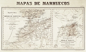
Spain. War of Africa (1859-1860). Maps of Morocco
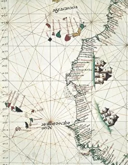
Map of the West of African coast with the Islands of Macaronesia, the Canary Isles and Cape Verde. 1514. Miniature Painting. PORTUGAL. Lisbon. Maritime Museum
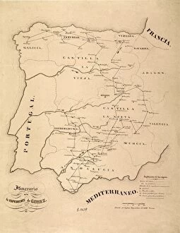
Spain. First Carlist War (1836). Map of Spain
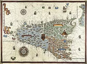
Chart by Joan Martines. Island of Sicily (1591). Miniature Painting
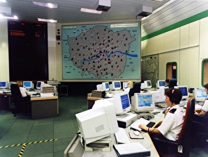
London Fire Brigade control room at headquarters. Officers work at computer stations to coordinate fire and rescue operations
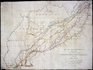
Map of Washington to New OrleansProposed road between Washington and New Orleans, c1830 through Virginia, Kentucky, North and South Carolina, Georgia, Tennessee, Mississippi, Alabama and Louisiana states Date: c. 1830
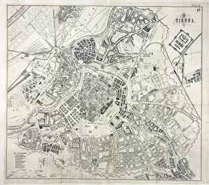
Map of Vienna, Austria Date: 19th century
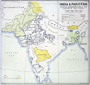
Map of India and PakistanIndia and Pakistan, showing States, and areas allocated to neither new country, 1948 Date: 1948
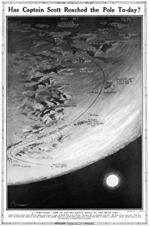
Has Captain Scott reached the Pole today?Page from The Sphere magazine speculating on whether Captain Robert Falcon Scott and his polar exploration team had reached the South Pole in December 1911, as scheduled
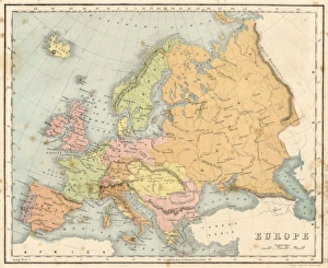
Map / Europe C1840Map of Europe Date: circa 1840
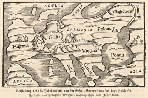
Map of Europe, 1550Europe, as conceived in 1550
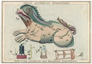
Cetus Star MapCetus (sea monster) and chemical factory and electrical machinery constellation
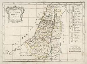
12 Tribes of IsraelThe distribution of the twelve Tribes of Israel; note also a small strip of coastline occupied by the Philistines
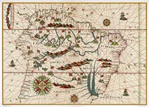
Map /s America / Brazil 16CMap of Brazil
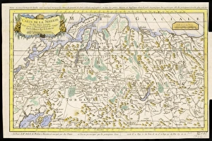
Map / Russia / Siberia 1764CARTE DE LA SIBERIE and adjoining lands
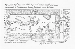
6th century World Map according to Cosmas Indicopleustes & his contemporaries
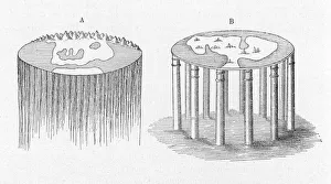
Early view of the worldEarth conceived as having roots reaching down into the Infinite; or as standing on it supported by columns
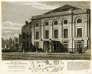
Surrey Theatre, Great Surrey Street, LondonThe Surrey Theatre (formerly The Royal Circus), Great Surrey Street, London, with a map below. 1814
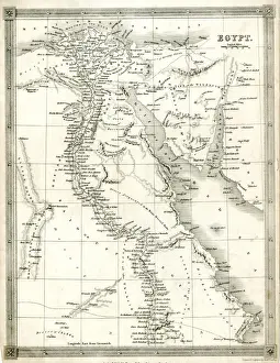
Map of Egypt. 1841
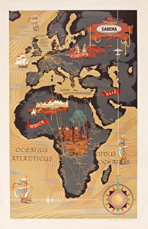
Advertisement for Sabena airlines, with a map of Europe, Africa and the Middle East. circa 1960
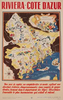
Advertisement for the French Riviera, Cote d Azur. circa 1946
Andrew Besley, photographer, Dartmoor, DevonAndrew Besley, photographer, with his camera at Cranmere Pool, Dartmoor, Devon. Date: circa 1960s
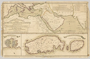
Three printed coloured maps: Fairburns New Chart Exhibiting the Route of General Buonaparte in the Mediterranean Sea; with the Countries through which the French Army must pass
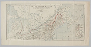
The Lake Frontier of Canada and the United States. From a collection of maps relevant to campaigns between 1794-1815. From the collection of the former Buffs Regimental Museum
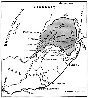
Theatre of war in South Africa - Boer War mapMap of the war in South Africa in 1899. Date: 1899
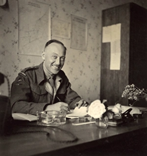
Soldier in an office, British Army of the Rhine, GermanySoldier in an office with charts and maps on the wall behind him, British Army of the Rhine, near Braunschweig (Brunswick), Lower Saxony, in postwar Germany. Date: circa 1946