mail_outline sales@mediastorehouse.com
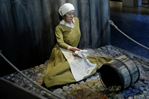
The Black Death. 14th century. Figure of a woman hit byThe Black Death. 14th century. Epidemic that ravaged the European continent. Figure of a woman hit by plague. Medieval Museum. Stockholm. Sweden. Date:
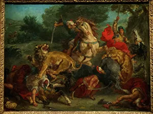
The Lion Hunt, 1855 or 1856, by Eugene DelacroixEugene Delacroix (1798-1863). French painter. The Lion Hunt, 1855 or 1856. National Museum. Stockholm. Sweden. Date:
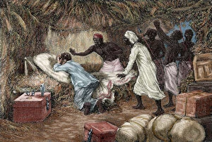
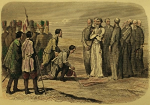
Death of David Livingstone (1813-1873). Engraving. ColoredDavid Livingstone (1813-1873). Scottish explorer. Death of Livingstone in the village of Chief Chitambo's, 1873. Engraving by Riov. The Illustrated World, 1882. Colored
Robert O'Hara Burke (1820 - 1861), Irish explorer, pictured shortly before his death in 1861. Burke had emigrated to Australia in 1853
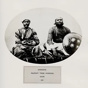
Chohans, Rajpoot tribe Hindoos. OudeThe People of India: A Series of Photographic Illustrations, with Descriptive Letterpress, of the Races and Tribes of Hindustan - published in the 1860s under order of the Viceroy
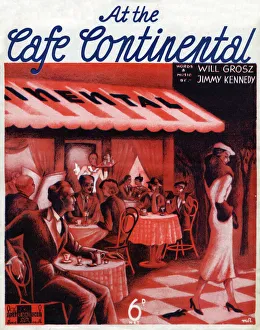
Music sheet cover for At the Cafe Continental by Will Grosz and Jimmy Kennedy. Illustration features a continental cafe with various patrons seated at outdoor tables
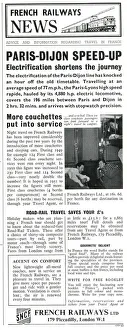
French Railway News - Paris-Dijon Speed-up - Electrification shortens the journey, knocking an hour off the old timetable. 1951
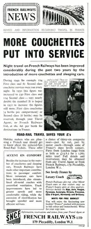
French Railway News - more Couchettes put into service. 1951
Off to the Continent? - British Railways Cross-Channel Services Date: 1956
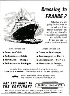
Crossing to France? Travel with British Railways. Date: 1953
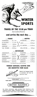
Winter Sports - travel to Europe with British Railways 1954
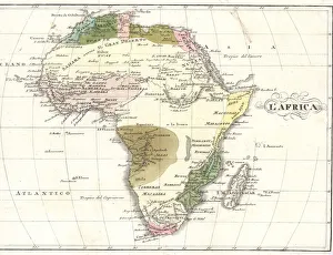
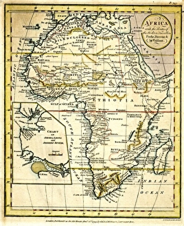
Map of Africa, circa 1820. Handcoloured copperplate engraving from Giulio Ferrrarios Costumes Antique and Modern of All Peoples (Il Costume Antico e Moderno di Tutti i Popoli), Florence, 1842
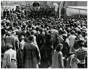
Outbreak of WWII English tourists at DieppeA large number of English tourists were caught on the Continent when war broke out in September 1939. Photograph shows crowds on the quayside at Dieppe trying to gain passage back to Britain
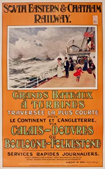
Poster, South Eastern & Chatham Railway, ferry crossings from Calais to Dover and from Boulogne to Folkestone. circa 1901
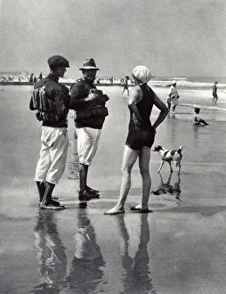
Life Savers on a Continental beachLife savers stationed on an unidentified Continental beach in 1923. Any adventurous swimmer who dared to swim out a little further than what was deemed perfectly safe was forcibly rescued often with
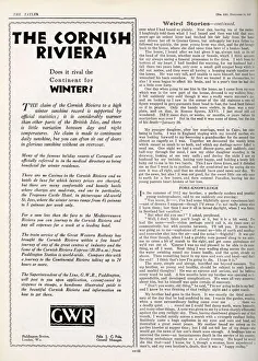
The Cornish Riviera in winterPage from The Tatler, 14th December 1927, featuring advert for the Cornish Riviera - does it rival the continent for winter? Travel by Great Western Railway. Date: 1927
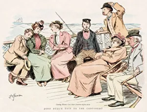
Passengers feeling poorly as the Channel boat pitches... Date: 1897
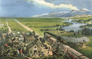
Westward the Course of Empire takes its Way Date: 1868
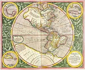
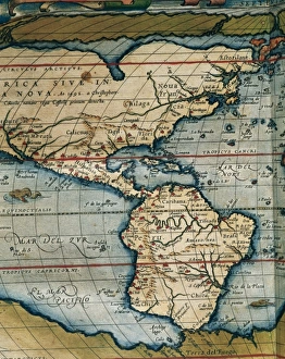
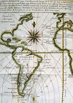
Map of the Americas1633 Date: 1633
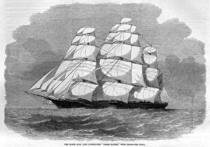
JAMES BAINES TROOPSHIPDuring the Indian Mutiny, the famous Black Ball line clipper James Baines is employed as a troopship to carry reinforcements to the troubled sub-continent. Date: 1857
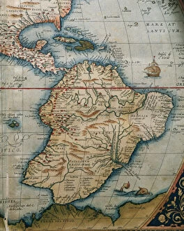
Map of Central and South America. Theatrum Orbis Terrarum by Abraham Ortelius (1527-1598). First Edition. Antwerp, 1574
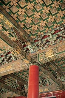
China. Beijing. Forbidden City. Coffered ceiling of a building in the interior
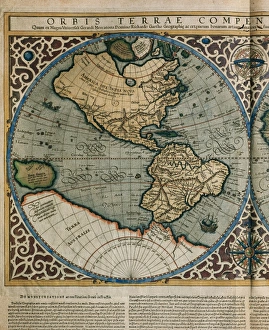
World Map by Rumold Mercator (1512-1594)Orbis Terrae Compendiosa Descriptio. World map, 1587. Detail of America. By Rumold Mercator (1545-1599)
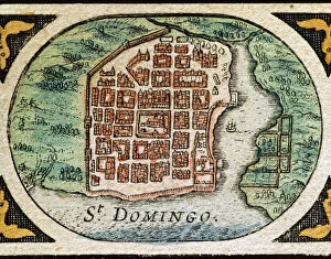
Santo Domingo (Dominican Republic). Hispaniola. Map in 1646
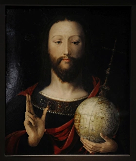
Salvator Mundi, 1537-1545Salvator Mundi. Christ with the Globe. 1537-1545. Lower Rhin. German Historical Museum. Berlin. Germany
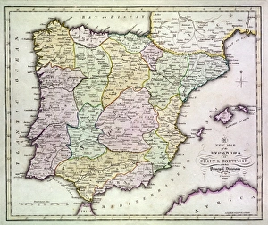
Map of Spain and Portugal, with part of southern France and northern Africa. Date: circa 1801
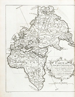
Map of the Old Continent (Europe, Africa, Asia). Engraving by J. vander Schley, from Pierre de Hondt, Histoire Naturelle generale et particuliere avec la description du Cabinet du Roy
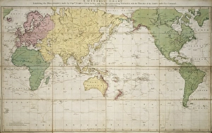
World map 1784 showing the Cook VoyagesA general chart exhibiting the discoveries made by Captain James Cook in this and his preceeding voyages with tracks of the ships under his command
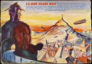
LEMURIAThe Lost Continent of Lemuria, located in todays Pacific Ocean, may have housed a highly developed civilisation with advanced technology and a sophisticated culture
Map of Africa, with travellers routesMap of Africa, with the routes of the modern travellers, Parke, Browne and Le Vaillant. 1799
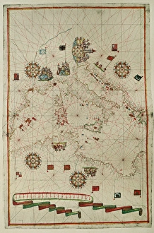
Portolan atlas by Joan Martines (1556-1590). WesternPortolan atlas of the world by Joan Martines (1556-1590). Messina, 1587. Western Mediterranean. National Library. Madrid. Spain
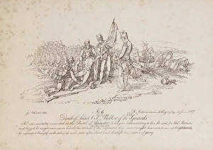
Death of Lt-Col William Miller of the 1st Guards at the Battle of Quatre Bras. One of 16 lithographs by J Atkinson depicting incidents of British bravery during the late campaigns on the continent
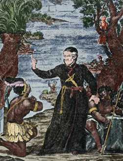
Antonio Vieira (1608-1697), Portuguese Jesuit philosopher anAntonio Vieira (1608-1697). Portuguese Jesuit philosopher and writer. Vieira preaching in Brazil. Colored engraving
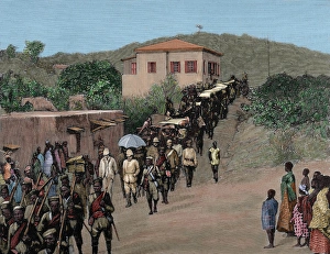
Governor Maxwell returns to Cape Coast Castle, from CumasiaFinal of the English expedition against the Ashantis. Governor Maxwell returns to Cape Coast Castle, from Cumasia. Engraving. Colored
Mexico. Francisco Fray Martin de Valencia received by HernanMexico. Evangelization. 16th C. Francisco Fray Martin de Valencia received by Hernan Cortes, May 12, 1524. Engraving. 1850. Color
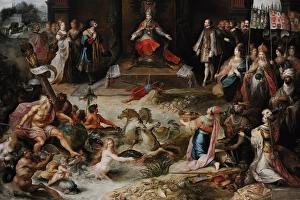
Allegory of the Abdication of Emperor Charles V in BrusselsFrans Francken the Younger (1581-1642). Flemish painter. Allegory of the Abdication of Emperor Charles V in Brussels, c.1630-1640. Rijksmuseum. Amsterdam. Holland
Theatrum Orbis Terrarum by Abraham Ortelius (1527-1598)Map of America. Theatrum Orbis Terrarum by Abraham Ortelius (1527-1598). First Edition. Antwerp, 1574
Map of the Atlantic Ocean. 18th centuryMap of the Atlantic Ocean from Newfoundland to Cape Horn. At A Voyage to the South-sea and along the coasts of Chili and Peru, in the years 1712, 1713 and 1714 by Amedee-Franc
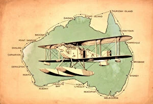
First circumnavigation of Australia by seaplane - 1924A map showing the route of the first circumnavigation of Australia by seaplane in 1924. On April 6, 1924, RAAF pilots Wing Commander Stanley James (Jimmy) Goble (1891-1948)
Mu and LemuriaThe submersion of MU - The great Pacific continent is overwhelmed by a combination of flood and volcanic action
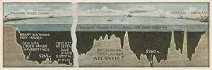
Atlantis Site ?Are the Azores, in mid- Atlantic, the site of the Atlantis continent ?
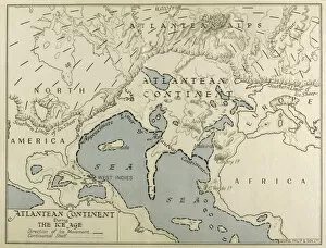
Atlantean Continent MapMap of the Atlantean Continent showing the extent of the Ice Age
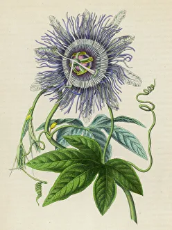
Passiflora -- Passion Flower -- brought from Peru/Brazil to Europe in 1699
Portolan atlas by Joan Martines (1556-1590). West CoastPortolan atlas of the world by Joan Martines (1556-1590). West Coast of the African Continent. Messina, 1587. National Library. Madrid. Spain
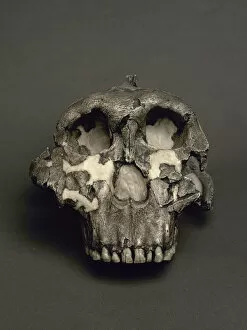
Cranium of Paranthropus boisei, named Dear Boy. 1, 8Reproduction of a Cranium of Paranthropus boisei, named Dear Boy. 1, 8 million years. From Olduvai Gorge, Tanzania. National Archaeological Museum. Madrid. Spain
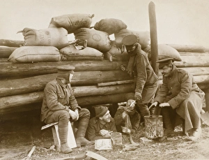
British soldiers resting behind a barricade on ContinentPhotograph: British soldiers resting behind a barricade on Continent.Shows five soldiers beside a wooden barricade topped with A.S.C. oat bags, through which one rifle is pointing
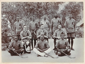
Regimental Hockey Team of the 1st BrahmansPhotograph: Regimental Hockey Team of the 1st Brahmans, 1910 (c).Sport was always important in the Indian Army. Hockey in particular was, and is, very popular in the Indian sub-continent
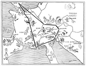
Social map of the ContinentA social map of the continent showing all the fashionable resorts during the 1930s including Biarritz, Monte Carlo, Cannes, Venice, Baden, Le Touquet, Deauville and St Mortiz. Date: 1934