mail_outline sales@mediastorehouse.com
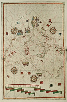
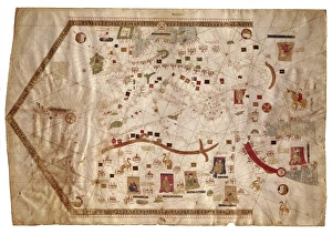
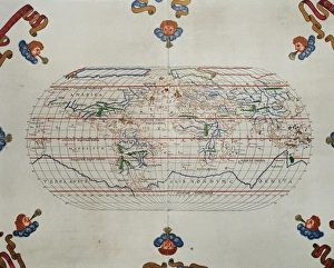
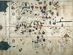
Portolan atlas by Joan Martines (1556-1590). WesternPortolan atlas of the world by Joan Martines (1556-1590). Messina, 1587. Western Mediterranean. National Library. Madrid. Spain
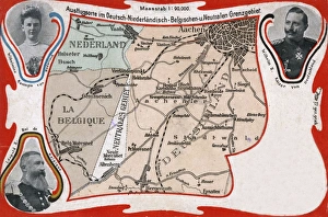
Neutral Moresnet - a small BelgianPrussian condominiumThe borders of Belgium, Germany and The Netherlands in 1906. of particular importance is the central feature of Neutral Moresnet - a small BelgianPrussian condominium that existed from 1816 to 1920
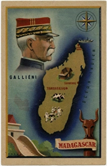
Gallieni, Colonial Administrator and Island of MadagascarMap of the (then) French Overseas Territory, the island of Madagascar in the Indian Ocean - with inset portrait of Joseph Simon Gallieni (1849-1916)
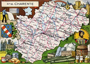
Map of the French Department of Charente - No. 16Map of the French Department of Charente - No.16, featuring inset illustrations of Paper production industry, La Rochefoucauld
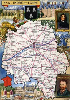
Map of the French Department of Indre-et-Loire - No. 37Map of the French Department of Indre-et-Loire - No.37, featuring inset illustrations of Chenonceaux, Langeais, Loches, Amboise and portraits of Rene Descartes, French philosopher, mathematician
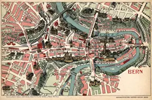
Map of Bern, Switzerland Date: 1905
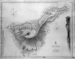
Map of Tenerife, Canary Islands, with soundings in fathoms. Date: 1838
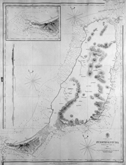
Map of Fuerteventura, Canary Islands, with soundings in fathoms. Date: 1835
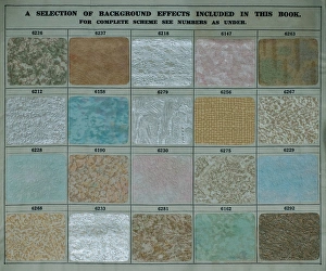
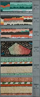
Background effects, SMB wallpaper sample bookA selection of background effects, with code numbers, in an SMB wallpaper sample book. Date: 1934
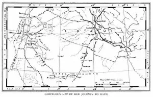
Gertrude Bells map of her journey to Hayil
When Women Vote Washing day. Mans worst nightmare - the housework is his domain, pictured washing his own shirts whilst holding the screaming baby. His duties are spelled out on a chart on the wall
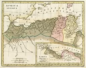
Map of Northern Africa. Date: 1807
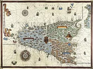
Chart by Joan Martines. Island of Sicily (1591). Miniature Painting
Portolan chart of the Mediterranean sea (1439) of Gabriel de Vallseca. It belonged to Amerigo Vespucci. SPAIN. Barcelona. Barcelona Maritime Museum
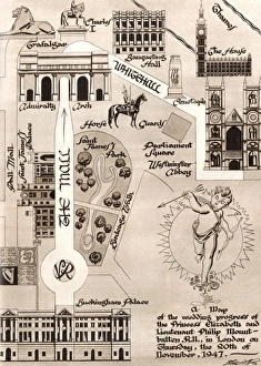
Royal Wedding 1947 - Processional RouteA decorative chart of the route taken by the Royal wedding procession from Buckingham Palace via the Mall, the Admiralty Arch, and Whitehall, to Westminster Abbey
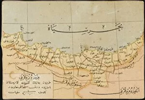
Map of the Trabzon ProvinceMap showing the Trabzon Province on the Black Sea coast in north-eastern Turkey. The capital of the Province, Trabzon was located on the historic silk road route and during the Ottoman period
Hill Alien AbductionBetty Hill abducted aboard an alien UFO is shown a star map by her abductors which is later shown to be accurate
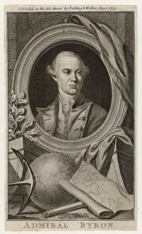
JOHN BYRON (1723 - 1786)JOHN BYRON Known as foul-weather Jack. English navigator and grandfather of poet Byron
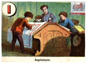
French Railway Alphabet - I for Ingenieurs (engineers). 19th century
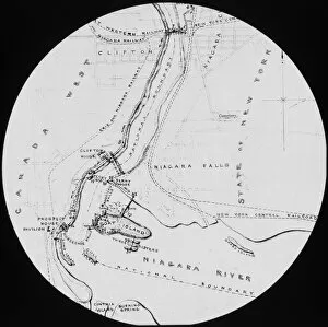
Map of the Niagara Falls. Date: circa 1890
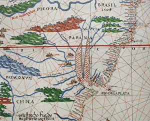
Portolan atlas by Joan Martines (1556-1590). Detail SouthPortolan atlas of the world by Joan Martines (1556-1590). Messina, 1587. Detail of South America. Atlantic Coast. National Library. Madrid. Spain
Portolan atlas by Joan Martines (1556-1590). West CoastPortolan atlas of the world by Joan Martines (1556-1590). West Coast of the African Continent. Messina, 1587. National Library. Madrid. Spain
Portolan atlas by Joan Martines (1556-1590). MessinaPortolan atlas of the world by Joan Martines (1556-1590). Messina, 1587. National Library. Madrid. Spain
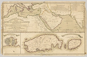
Three printed coloured maps: Fairburns New Chart Exhibiting the Route of General Buonaparte in the Mediterranean Sea; with the Countries through which the French Army must pass
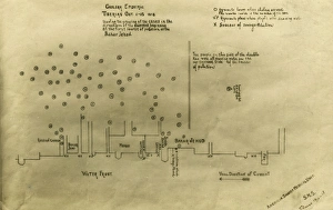
Cholera epidemic, Tiberias, IsraelCholera epidemic, Tiberias, Lower Galilee, Israel, 1-15 October 1918 -- chart drawn by the American Zionist Medical Unit (part of a missionary society), showing cases to the west of Bahar Jehud
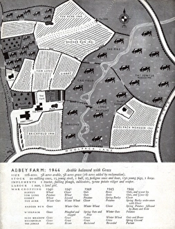
Farming pre-war in 1944 - layout of fields and crops (2 / 2)Abbey Farm - 1944. The standard farm layout during WW2 in Britain (from 1944) showing the layout of fields and crops, Arable balanced with Grass
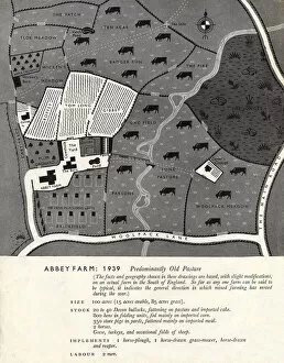
Farming pre-war in 1939 - layout of fields and crops (1 / 2)Abbey Farm - 1939. The standard farm layout pre-WW2 in Britain (from 1939) showing the layout of fields and crops, predominantly old pasture
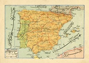
An Ottoman map of the Iberian Peninsula Date: circa 1890s
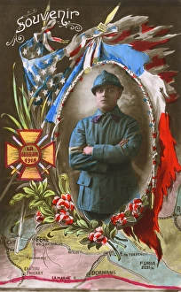
Souvenir postcard celebrating Victory - Battle of the Marne Date: circa 1916
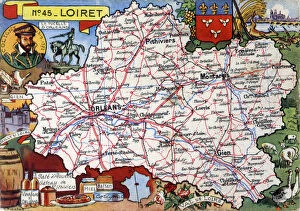
Map of the French Department of Loiret - No. 45Map of the French Department of Loiret - No.45, featuring inset illustrations depicting Sully sur Loire, ceramics from Gien, foodstuffs from Orleans and an inset portrait of Gaspard II de Coligny
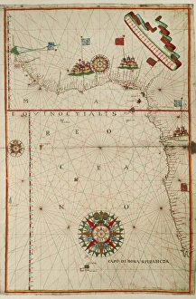
Chart by Juan de la Cosa (1450-1510). Spain. Madrid. Mavy Museum
William Ramsay / Vfair 08SIR WILLIAM RAMSAY British chemist giving a lecture Date: 1852 - 1916
Fw Herschel / ScrivenSIR FREDERICK WILLIAM HERSCHEL German-English astronomer with a plan of the planet Uranus, discovered in 1781 Date: 1738 - 1822
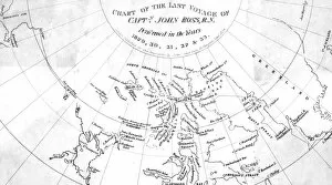
Ross / Chart of VoyageJohn Rosss arctic expedition: chart of his last voyage. Date: 1829 - 33
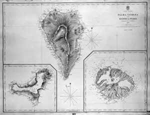
Map of Palma, Gomera and Hierro, Canary IslandsMap of Palma, Gomera and Hierro (or Ferro), Canary Islands, with soundings in fathoms. Date: 1837
Map of Naos and Arrecife, Lanzarote, Canary IslandsMap of the ports of Naos and Arrecife, Lanzarote, Canary Islands, surveyed by the Spanish Navy in 1853, with outer soundings from a survey of 1835, updated in 1880. Date: 1881
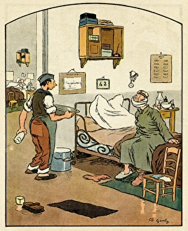
Cartoon, On the eve of repatriation, WW1Cartoon, On the eve of repatriation. A German patient in a French hospital asks an orderly if he will be ok with his reconstructed chin containing silver
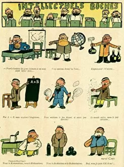
Cartoon, Boche intellectuals, WW1Cartoon, Boche intellectuals, showing a variety of German boffins doing their work. Date: 1916
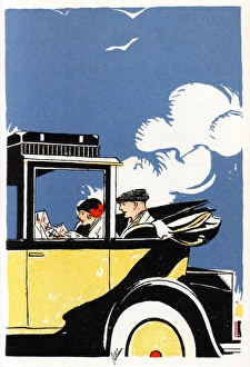
American couple studying a map in an elegant automobileAmerican couple studying a map, riding in the open-top rear section of an elegant cream-colured car, their luggage carefully stowed in the roofrack. Date: 1920s
Border designs, SMB wallpaper sample bookSix art deco style border designs in an SMB wallpaper sample book. Date: 1934
Post Office Chart, Hullbridge, EssexPost Office Chart, Hullbridge, Hockley, near South Woodham Ferrers, Essex, England. Date: 1950s
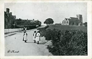
The Village, Great Chart, KentThe Village, Great Chart, Ashford, Kent, England. Date: 1910s
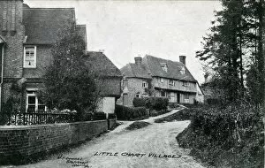
The Village, Little Chart, KentThe Village, Little Chart, Ashford, near Pluckley, Kent, England. Date: 1910s
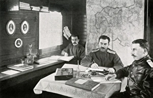
WW1 - Eastern Front - Russian Staff Officers on a TrainWW1 - Eastern Front - Russian Staff Officers in their office onboard a Railway Train Date: 1915
Atlas by Fern㯠Vaz Dourado, 1571. Chart 1: NorthernAtlas by Fern㯠 Vaz Dourado, 1571. Chart 1: Northern Europe. Renaissance art. Miniature Painting. PORTUGAL. Lisbon. National Archive of the Tower of the Tombo
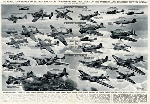
Aerial gunpower in 1940 by G. H. DavisThe aerial gunpower of Britain, France and Germany: the armament of the bombers and fighters now in action. Machine gun versus canon
Advertisement for Robbialac paint, from Jenson & Nicholson of Stratford, East London. It costs less than wallpaper, slightly more than distemper, but its durability makes it far cheaper than either
H. E. BatesHerbert Ernest Bates (1905 74), British writer and author, best known for The Darling Buds of May, Love for Lydia and My Uncle Silas