mail_outline sales@mediastorehouse.com
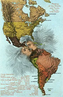
Kiss of the Oceans - Atlantic meets Pacific - Panama CanalThe Kiss of the Oceans - The Atlantic meets the Pacific due to the construction of The Panama Canal - A lovely allegorical card relating to this phenomenal engineering project
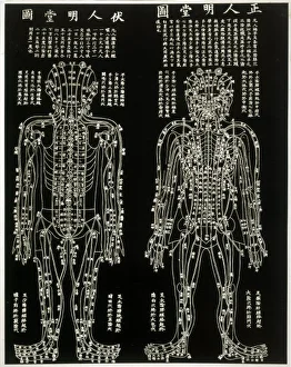
Chinese AcupuncturechartCHINESE ACUPUNCTURE CHART showing the crucial locations on the body
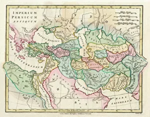
Map of the Ancient Persian Empire, encompassing Greece to the north west, Arabia to the south east, Egypt and Libya to the south west and deep in the Caucasus in the north east. Date: 1798
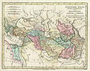
Map of the Empire of King Alexander the Great (Alexander III of Macedon 356323 BC), from Greece in the west to India in the east. Date: 1807
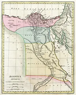
Map of Ancient Egypt. Date: 1814
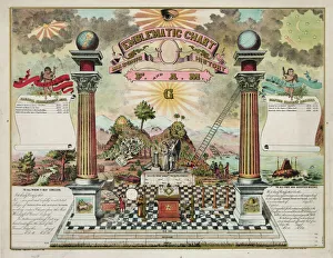
Emblematic chart and Masonic history of Free and Accepted Ma
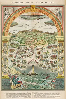
Salvation Army CampaignA social campaign chart
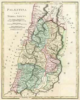
Map of Palestine and the Holy Land - all places named in their Latin form. Date: 1806
Masonic chart. Date c1872
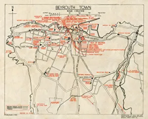
WW2 - Map of Beirut, Lebanon - with Military locationsEnd of WW2 - Map of Beirut, Lebanon showing Military locations important for a British serviceman stationed in the city at the end of the Second World War
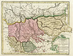
Map of the Macedonian and Thracian Empire. Date: 1808
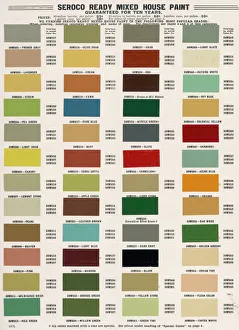
Paint Chart / 1908PAINT CHART
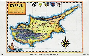
Map of Cyprus - The Island of Venus. circa 1930s
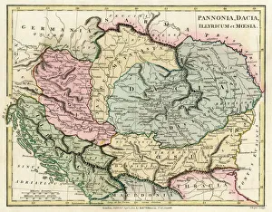
Map of the Dacian Empire and Roman provinces. Date: 1801
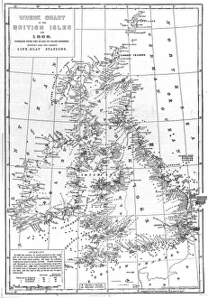
Wreck Chart of the British Isles For 1868Chart showing the positions of all 2131 vessels wrecked around the British Isles during 1868, compiled from the Board of Trade records
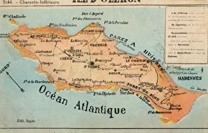
Ile d Oleron - off the French Atlantic CoastIle d Oleron - an island off the Atlantic coast of France, on the southern side of the Pertuis d Antioche strait. It is the second largest island of Metropolitan France, after Corsica
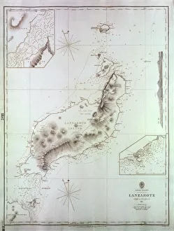
Map of Lanzarote, Canary Islands, with soundings in fathoms. Date: 1835
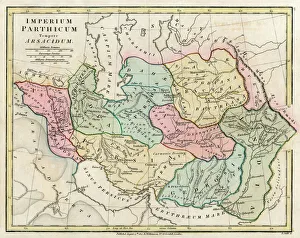
Map of Persia (Iran) - all place names in their Latin form. The ancient realms of Assyria, Babylonia Date: 1807
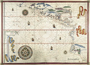
Portolan chart, 1591. Map of the Pacific Ocean. It depicts the western coast of Central and South America, from Mexico to the Strait of Magellan. Renaissance art. Miniature Painting
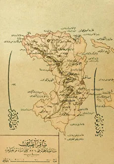
A Map of the Island of ChiosA Turkish Map of the Greek Island of Chios, at this point under Ottoman Turkish control. The island is in the Aegean Sea only 5 miles off the coast of Asia Minor
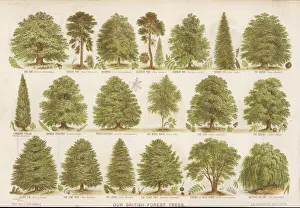
British Forest TreesA chart of British forest trees
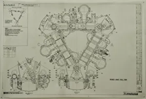
D Napier and Son - DelticGeneral arrangement of Deltic 18-11B MTB Driving End
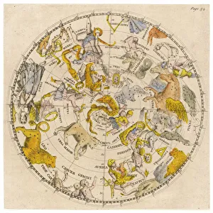
SKY CHARTSky chart showing the signs of the Zodiac and other celestial features
Masonic chart. Date c1846 May 28
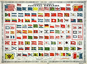
Johnsons new chart of national emblems
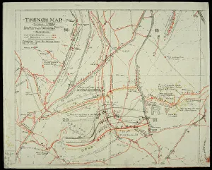
WW1 - Trench map from a soldiers war diary showing the Somme Battlefield with information gleaned from captured German Prisoners
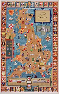
Poster, Map of Royal Britain. 1957
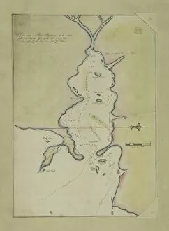
An eye-sketch of Port Stephens, to the north of Broken BayDrawing LS 4 from the Watling Collection titled High water at Port Stephens at 10 o clock by a Port Jackson Painter, 1791-1792
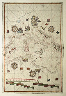
Portolan chart, 1582. Map of the central part of the Mediterranean sea. Printed in Messina. Renaissance art. Miniature Painting
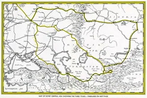
Map of Soviet Central Asia - showing marked tour routes. Date: 1933
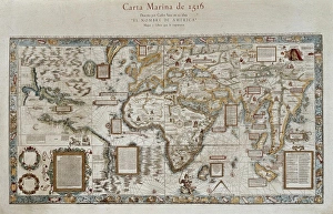
Carta marina (map of the sea). 1516. Facsimile" Carta marina (map of the sea). 1516. Facsimile. Sea map described by Carlos Sainz in his work " The name of America". Engraving. SPAIN. Madrid. Americas Museum."
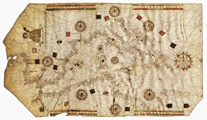
Nautical chart entitled King Hamy. 1502. Parchment" Nautical chart entitled " King Hamy". 1502. Parchment. Miniature Painting. SPAIN. Barcelona. Barcelona Maritime Museum."
Chinese Acupuncture CharAn ancient Chinese acupuncture chart
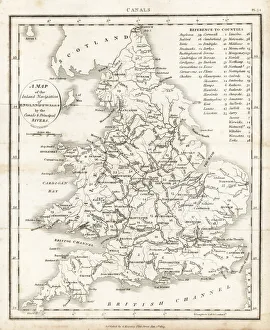
Inland navigation of England and Wales byMap of the inland navigation of England and Wales by the canals and principal rivers, 1809. Copperplate engraving by Mutlow from John Mason Goods Pantologia, a New Encyclopedia, G
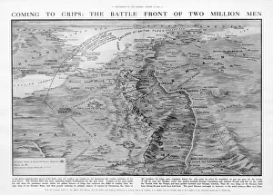
The Western Front battleground - map of August 1914WW1 - The Western Front battleground - map of August 1914 Date: 1914
Christmas scene at the Evelina Childrens HospitalChristmas comes but once a year -- a scene at the Evelina Childrens Hospital, founded in Southwark, London, in 1869. A sick little girl is visited by her mother and younger sister
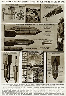
Types of war bombs in use by G. H. DavisInstruments of destruction: types of war bombs in use during the Second World War. A comparative chart showing the various types, including the incendiary, the high explosive, the armour piercing
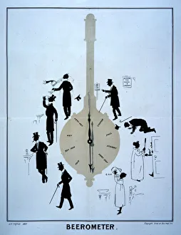
Beerometer 1897 Date: 1897
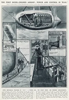
Power and control in R101The first diesel-engined airship: power and control in R101. Illustrations of some of the features of R101: a power car, the chart room, and mooring arrangements
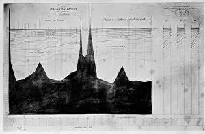
Chart of oceanic section, Madeira, Portugal to St. VincentA photograph taken during the voyage of H.M.S. Challenger (1872-1876) funded by the British Government for scientific purposes
Illustrated political chart, a cartoon of American politics and the Tapeworm Party. Print shows James G. Blaine as the head of a tapeworm made up of various government scandals over a map of
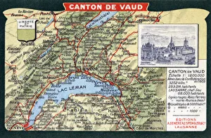
Map of the Canton of Vaud, Switzerland, including Vevey, Lausanne and Lac Leman. Date: circa 1910s
Comic postcard, Doctor, nurse and patient - rising temperature Date: 20th century
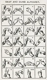
Deaf and Dumb Finger AlphabetA chart of the finger-spelling alphabet used by many deaf people. Date: circa 1905
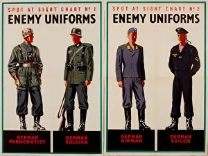
Two posters, Spot at Sight, Enemy Uniforms, WW2. German parachutist, soldier, airman and sailor. 1940s
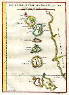
Moluccas
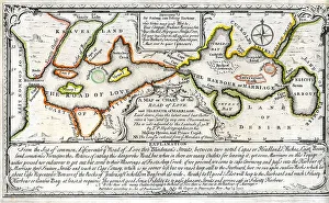
Map of The Road To Love
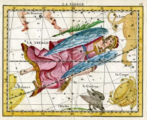
Virgo - Virgin, Angel