Map of the Mediterranean (Add. Ms. 25691). It
. It")
![]()
Wall Art and Photo Gifts from Mary Evans Picture Library
Map of the Mediterranean (Add. Ms. 25691). It
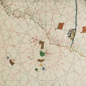
Map of the Mediterranean (Add.Ms. 25691). It is probably the oldest portolan chart from the school of Mallorca ca. 1327-1330. Are represented Italy, Sicily and North Africa. Miniature Painting. UNITED KINGDOM. London. The British Museum
Media ID 8283811
© Mary Evans/Iberfoto
Chart Mallorca Mediterranean Oldest Portolan Represented Sicily
MADE IN THE UK
Safe Shipping with 30 Day Money Back Guarantee
FREE PERSONALISATION*
We are proud to offer a range of customisation features including Personalised Captions, Color Filters and Picture Zoom Tools
SECURE PAYMENTS
We happily accept a wide range of payment options so you can pay for the things you need in the way that is most convenient for you
* Options may vary by product and licensing agreement. Zoomed Pictures can be adjusted in the Basket.