mail_outline sales@mediastorehouse.com
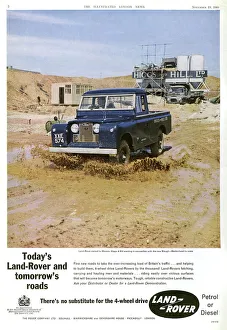
Land Rover advertisement, 1960Advertisement for Land Rover showing a photograph of it in use to travel over rough terrain during the work on the new Slough - Maidenhead by-pass in 1960. Date: 1960
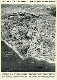
Nettuno-Anzio Front, Italy, by G. H. DavisThe battle of the beachhead -- an airmans view of the terrain. A pictorial map of the Nettuno-Anzio Front, showing roads, with the Alban Hills in the background
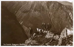
Fox Hunting party, Newlands, Keswick, Lake District, CumbriaA spectacular real photographic postcard showing a Fox Hunting party at Newlands, Keswick, Lake District, Cumbria, standing on the edge of a dramatic valley. Date: circa 1920s
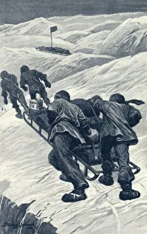
Shackleton / Sledging / 1908Ernest Shackletons expedition reached within 100 miles of the South Pole. Relaying sledges over the rough terrain. Date: 1908
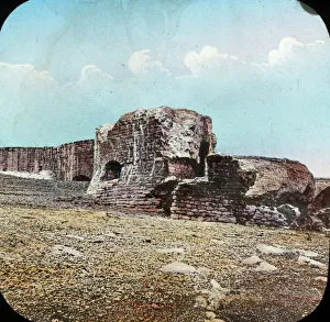
Sandown Castle - view across rough terrain towards walls. Part of Box 3 Boswell Collection Series of Ancient Britain. Date: circa 1900
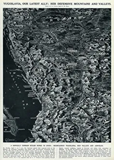
Map of Yugoslavia by G. H. DavisMap of Yugoslavia, Britains latest ally in the Second World War: her defensive mountains and valleys. Mountainous Yugoslavia, her valleys and airfields. Date: 1941
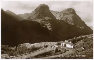
Glen of Weeping, Glencoe, ScotlandGlen of Weeping - Glen Coe - a glen in the Highlands of Scotland. It lies in the southern part of the Lochaber committee area of Highland Council, and was formerly part of the county of Argyll
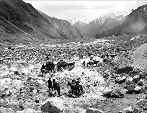
Mountain travellers in Kashgar, western ChinaTravellers making their way through the mountains of Kashgar, western China. Photograph by Ralph Ponsonby Watts
The Zulu war. Fort Bengough. Church Parade of officers and nBritish army ranks were substantially swelled by the NNC during the Zulu wars; their local knowledge of terrain and languages were invaluable
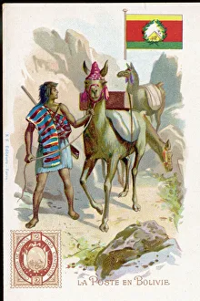
Social / Bolivia PostmanIn the mountainous terrain of Bolivia, a rural postman uses mules to carry the mails
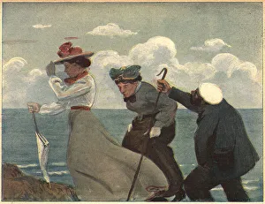
Sur La GreveA sketch of a lady holding the brim of her decorative hat, followed by an older woman clutching her skirts and a man equipped with a crook, walking on rocky terrain overlooking the ocean
The Congo. Climbing a slope in the Mpagassa GorgeHistory of Africa. 19th century. Climbing a slope in the Mpagassa Gorge. Engraving. El Congo y la Creacion del Estado Independiente de este nombre
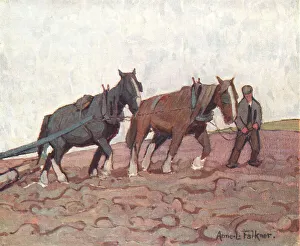
The RollerThis oil painting shows an old farmer leading a pair of work horses, coloured brown and black, along earthy terrain, they are dragging an agricultural roller, for compacting the ground
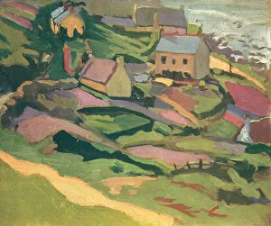
Small Coast TownA landscape painting of some countryside houses, placed sporadically over slanting, grassy terrain. Date: circa 1920
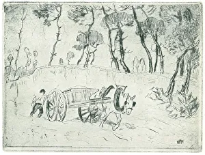
Horse and CartAn etching of a strong workhorse, pulling a cart over some rough terrain, at the edge of a woodland, with a farmer trailing behind. Date: circa 1920
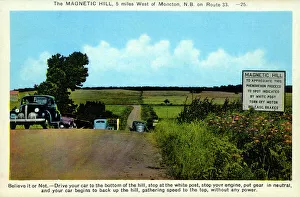
The Magnetic Hill, Moncton, New Brunswick, CanadaThe Magnetic Hill is an example of a gravity hill, a type of optical illusion created by rising and descending terrain. It is located at the northwestern edge (in the Magnetic Hill Area)
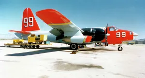
Lockheed SP-2H Neptune N299MA - 99Lockheed SP-2H Neptune N299MA / 99 (msn 726-7211), fire-bomber of Minden Air Corp. This aircraft was destroyed in a Controlled Flight Into Terrain (CFIT) on 3 October 2003. Date: circa 1998
Grumman S-2H Tracker N52345A - 136404 (MSN 313). (Destroyed on 3 May 2007, when it collided with power lines and terrain during a forced landing near Cherry Point Marine Corps Air Station (NKT)
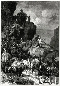
English Army on the march to Magdala, Abyssinia (Ethiopia), Abyssinian War (a rescue mission for the recovery of hostages). British forces took three months to advance across mountainous terrain
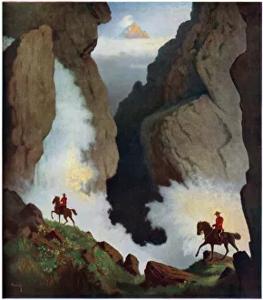
Canadian Mounties - To Maintain the Law by Arthur HemingMembers of the Royal Canadian Mounted Police, commonly known as " Mounties", riding through the Rockies in Canada on horseback, the terrain making motorcycles redundant
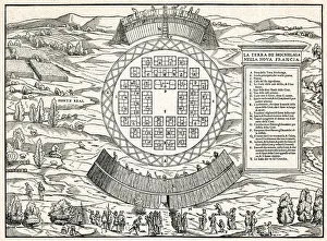
Township of Hochelaga Visited by CartierA terrain map of the town of Hochelaga visited by Jacques Cartier in 1535, a circular collection of buildings surrounded by a wooden palisade on either side. At the bottom, French and St
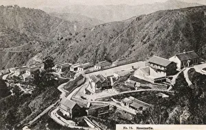
Village of Newcastle in the Mountains of Jamaica, Caribbean Date: 1909
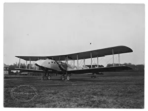
Armstrong Whitworth Awana - J6860Armstrong Whitworth Awana J6860. The Awana was designed in response to Air Ministry Specification 5/20 for a twin-engined Troop Carrying Aeroplane
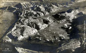
WW1 - Aerial View of the Dardanelles Battlefields, TurkeyWW1 - Aerial View of the Dardanelles Battlefield theatre, Turkey on 18th March 1915. 1915
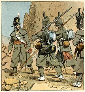
NAPOLEONIC BRIT 18141st Regiment of Foot Guards in Spain during the Peninsular Campaign Date: 1814
Bolivian PostmanIn the mountainous terrain of Bolivia, a rural postman uses mules to carry the mails. Date: circa 1900
Fairchild A-10 Thunderbolt II / 2USAF 355th Tfw Fairchild A-10 Thunderbolt II / 2 Flying over Desert Near Tuscon, Arizona Date: 1980s
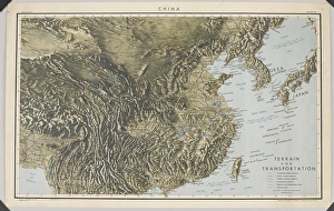
WW2 - Map of China, Korea, Formosa and the southern part ofMap of China, Korea, Formosa and the southern part of Japan, 27 Mar 1944. Compiled and drawn in the Branch of Research and Analysis, oss
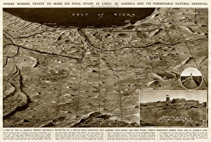
Defences of El Agheila, Libya, by G. H. DavisWhere Rommel planned to make his final stand in Libya during the Second World War: El Agheila and its formidable natural defences
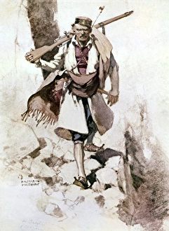
Serbian soldier, WW1A Serbian soldier in rocky terrain during the First World War. Date: 1914-1918
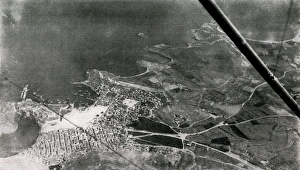
WW1 - Aerial view of Gallipoli, 1915WW1 - A photograph of a town in Gallipoli, Turkey, 1915, taken from one of the allied aeroplanes operating at the Dardanelles
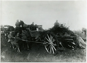
German Artillery CartGerman troops on the Western Front, showing the difficulties involved in hauling heavy artillery across the muddy terrain on horse and cattle drawn carts. Date: 1918
European coastline 1944A double page spread of The Illustrated London News, published less than a month before the Allied D-Day Normandy landings
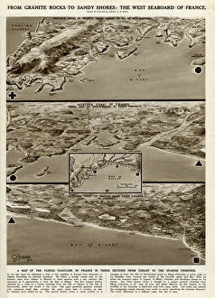
West seaboard of France by G. H. DavisA supplementary illustration to that which had appeared in the previous issue of The Illustrated London News (picture 10948123)
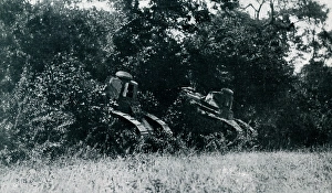
WW1 - M1917 American tanks in actionWW1 - Two American M1917 tanks in action as they move towards, and plough through a forested terrain. Date: 1918
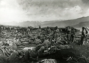
WW1 - Russian troops rest after battle on Turkish front Date: 1916
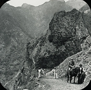
Visit to Madeira - Road near the Grand CurralBlack and white lantern slide of several men at the top of a road, in the background is mountainous terrain - Visit to Madeira. Part of Box 125 - Madeira. Boswell Collection. Date: circa 1890s
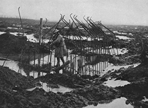
British soldier examing framework of pill-box, WW1A muddy and flooded landscape in Flanders with a British soldier inspecting the skeleton framework of an uncompleted pill-box
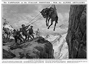
Artillery mule on Italian frontierOn the Italian frontier, an artillery mule is lowered on to a ledge in the Alps. The mules were used by the Italian Alpine artillery to carry gun parts on their backs across the mountainous terrain
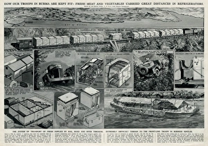
Allied troops in Burma by G. H. DavisHow the Allied troops in Burma are kept fit: fresh meat and vegetables carried great distances in refrigerators. Showing the system of transport of fresh supplies by rail
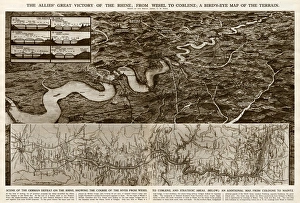
Allies victory of the Rhine by G. H. DavisThe Allies victory of the Rhine during the Second World War: from Wesel to Coblenz. A birds eye map of the terrain, with an additional map from Cologne to Mainz. Date: 1945
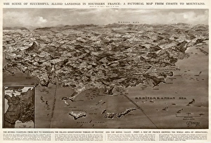
Allied landings in southern France by G. H. DavisThe scene of successful Allied landings in southern France during the Second World War: a pictorial map from coasts to mountains. Date: 1944
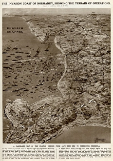
Invasion coast of Normandy by G. H. DavisThe invasion coast of Normandy, showing the terrain of operations during the Second World War. A panoramic map of the coastal regions from Cap Gris Nez to the Cherbourg Peninsula. Date: 1944
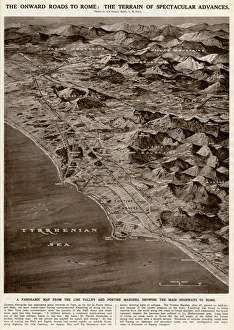
Onward roads to Rome by G. H. DavisThe onward roads to Rome: the terrain of spectacular advances during the Second World War. A panoramic map from the Liri Valley and Pontine Marshes, showing the main highways to Rome. Date: 1944
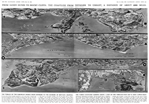
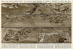
Coastline from Denmark to Ushant by G. H. DavisFrom sandy dunes to rocky cliffs: the coastline from Denmark to Ushant (Brittany), a distance of about 1200 miles. The terrain of the European shores from Denmark to the extreme of Brittany
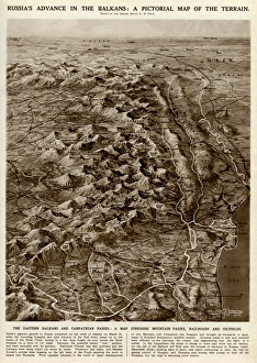
Russian advance in Balkans by G. H. DavisRussias advance in the Balkans during the Second World War: a pictorial map of the terrain. The Eastern Balkans and Carpathian passes: a map showing mountain passes, railways and oilfields. Date: 1944
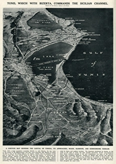
Tunis commanding Sicilian Channel by G. H. DavisTunis, which with Bizerta commands the Sicilian Channel. A contour map showing the capital of Tunisia, its approaches, roads, harbour and surrounding terrain
Map of northern Tunisia by G. H. DavisThe battleground which was expected to seal the fate of North Africa and gain full control of the Mediterranean during the Second World War