mail_outline sales@mediastorehouse.com
Military radar in wartime by G. H. DavisMilitary radar: how this vital secret weapon helped the Allied land forces to achieve final victory during the Second World War. Date: 1945
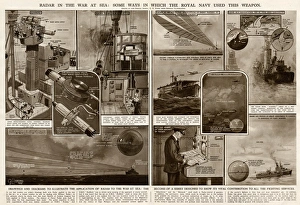
Use of radar in the war at sea by G. H. DavisRadar in the war at sea: some ways in which the Royal Navy used this weapon during the Second World War. Date: 1945
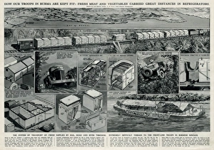
Allied troops in Burma by G. H. DavisHow the Allied troops in Burma are kept fit: fresh meat and vegetables carried great distances in refrigerators. Showing the system of transport of fresh supplies by rail
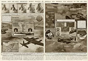
Use of radar in the air war by G. H. DavisRadar: how the most important secret weapon of offence and defence was applied to the air war. Its vital contribution to all the fighting services during the Second World War. Date: 1945
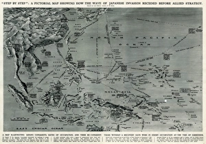
Map of Japanese invasion receding by G. H. DavisA pictorial map of the Pacific area, showing how the wave of Japanese invasion receded as a result of the Allied strategy during the Second World War
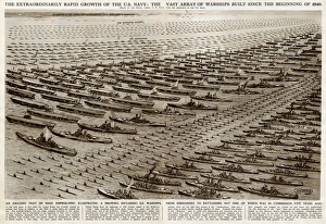
Growth of the US Navy by G. H. DavisThe rapid growth of the US Navy during the Second World War: the vast array of warships built since the beginning of 1940. Showing US warships, from submarines to battleships. Date: 1945
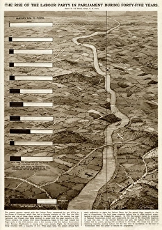
Rise of the Labour Party in Britain by G. H. DavisThe rise of the Labour Party in the British Parliament over the course of 45 years, symbolised as a river growing wider and wider
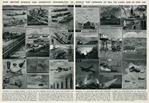
British science and ingenuity in war by G. H. DavisHow British science and ingenuity contributed to the defeat of the Germans at sea, on land, and in the air. A few of the many weapons, devices and tactics, both offensive and defensive
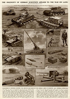
German inventions for war on land by G. H. DavisThe ingenuity of German scientists applied to the war on land. Illustrating the German armys exploitation of scientific and technical inventions during the Second World War. Date: 1945
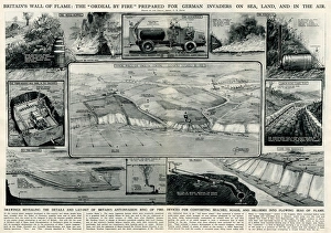
Anti-invasion ring of fire by G. H. DavisBritains wall of flame: the ordeal by fire prepared for German invaders on sea, land, and in the air. Showing the details and layout of an anti-invasion ring of fire: devices for converting beaches
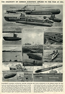
German inventions for war at sea by G. H. DavisThe ingenuity of German scientists applied to the war at sea. Illustrating maritime inventions and tactics introduced by the Germans during the Second World War. Date: 1945
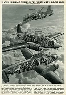
British Vickers Viking airliner by G. H. DavisAnother British air challenge: the Vickers Viking 27-seater airliner. Details of a medium transport aircraft designed to give Britain a lead in the field of civil aviation. Date: 1945
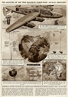
Locating true magnetic North Pole by G. H. DavisThe locating of the true magnetic North Pole: an RAF discovery. Illustrating the 17, 720-mile polar expedition of the British Lancaster Aries and her crew. Date: 1945
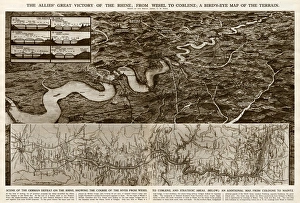
Allies victory of the Rhine by G. H. DavisThe Allies victory of the Rhine during the Second World War: from Wesel to Coblenz. A birds eye map of the terrain, with an additional map from Cologne to Mainz. Date: 1945
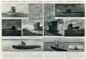
U-boat warfare 1939-1945 by G. H. DavisU-boat warfare 1939-1945: a survey of changing German submarines and tactics in a never-ceasing battle during the Second World War
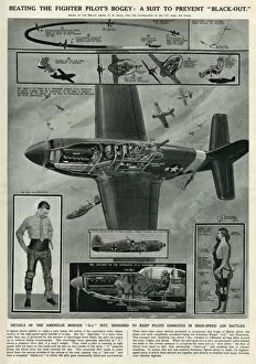
Suit to prevent pilot blackout by G. H. DavisBeating the fighter pilots problem: a suit to prevent blackout. Details of the American Berger G2 suit, designed to keep pilots conscious in high-speed air battles during the Second World War
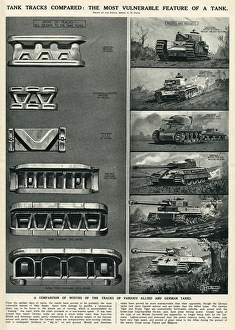
Tank tracks compared by G. H. DavisTank tracks compared: the most vulnerable feature of a tank. Showing various tanks in use during the Second World War: the Churchill and the Cromwell (British), the Sherman (American)
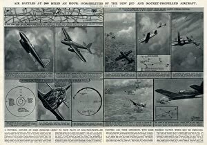
Air battles at 500 mph by G. H. DavisAir battles at 500 miles an hour: possibilities of the new jet- and rocket-propelled aircraft. A pictorial outline of some problems likely to face pilots
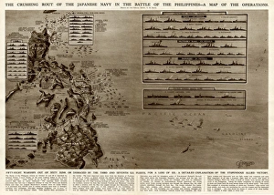
Battle of the Philippines by G. H. DavisThe crushing rout of the Japanese Navy in the Battle of the Philippines during the Second World War. A map of the operations
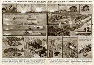
Destructive force of flying bomb by G. H. DavisBlast -- the main destructive force of the flying bomb in use during the Second World War. How and why it creates widespread damage
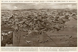
Allied landings in southern France by G. H. DavisThe scene of successful Allied landings in southern France during the Second World War: a pictorial map from coasts to mountains. Date: 1944
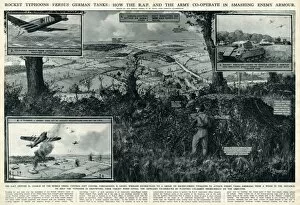
RAF and Army cooperate against enemy by G. H. DavisRocket typhoons versus German tanks: how the RAF and the Army cooperate in smashing enemy armour during the Second World War
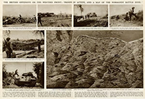
British offensive on Western Front by G. H. DavisThe British offensive on the Western Front during the Second World War: troops in action, and a map of the Normandy battle zone. Date: 1944
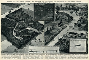
Bomb launching installations in France by G. H. DavisHomes of the flying bombs: the layout of launching installations in northern France during the Second World War. They are sometimes camouflaged among woods, or disguised as small villages. Date: 1944
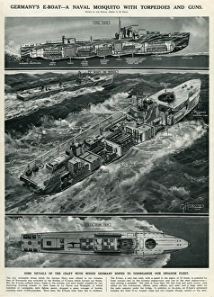
Germanys E-boat by G. H. DavisGermanys E-boat -- a naval mosquito with torpedoes and guns, in use during the Second World War. The craft which Germany hoped would help disorganise the Allied invasion fleet. Date: 1944
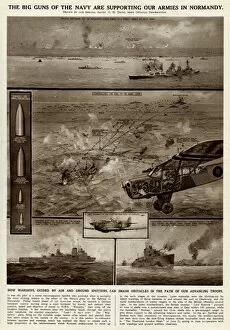
Naval support for armies in Normandy by G. H. DavisThe big guns of the Royal Navy supporting the Allied armies in Normandy during the Second World War. How warships, guided by air and ground spotters
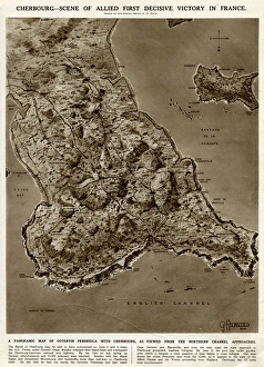
Cherbourg, scene of victory, by G. H. DavisCherbourg -- scene of Allied first decisive victory in France during the Second World War. A panoramic map of Cotentin Peninsula with Cherbourg, as viewed from the northern Channel approaches
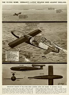
German flying bomb by G. H. DavisThe flying bomb: Germanys latest weapon used against England during the Second World War. Explanatory drawings of the flying robot launched across the Channel to southern England. Date: 1944
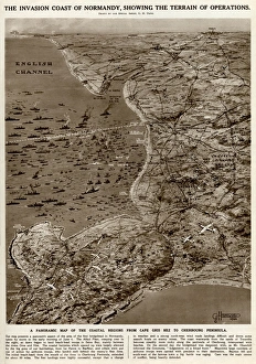
Invasion coast of Normandy by G. H. DavisThe invasion coast of Normandy, showing the terrain of operations during the Second World War. A panoramic map of the coastal regions from Cap Gris Nez to the Cherbourg Peninsula. Date: 1944
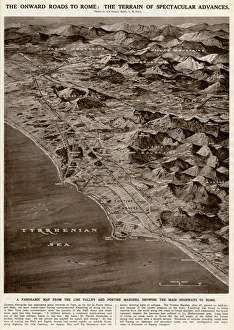
Onward roads to Rome by G. H. DavisThe onward roads to Rome: the terrain of spectacular advances during the Second World War. A panoramic map from the Liri Valley and Pontine Marshes, showing the main highways to Rome. Date: 1944
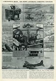
Sperry automatic computing gun sight by G. H. DavisA mechanical brain: the Sperry automatic computing gun sight, in use during the Second World War. An invention which enabled US bombers to target a large number of enemy fighters. Date: 1944
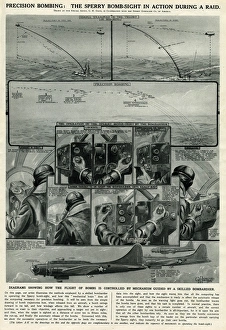
Sperry bomb sight in action by G. H. DavisPrecision bombing: the Sperry bomb sight in action during a raid, Second World War. The flight of bombs is controlled by a mechanism guided by a skilled bombardier. Date: 1944
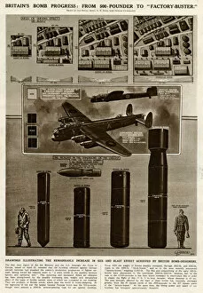
Britains bomb progress by G. H. DavisBritains bomb progress during the Second World War: from 500-pounder to a 12, 000-pound factory buster. Date: 1944
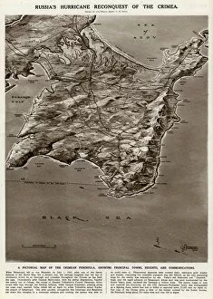
Map of the Crimean peninsula by G. H. DavisRussias reconquest of the Crimea during the Second World War. A pictorial map of the Crimean peninsula, showing principal towns, heights and communications. Date: 1944
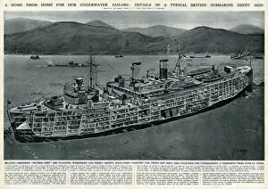
British submarine depot ship by G. H. DavisA home from home for underwater sailors during the Second World War: details of a typical British submarine depot ship. These mother ships were floating workshops and supply depots
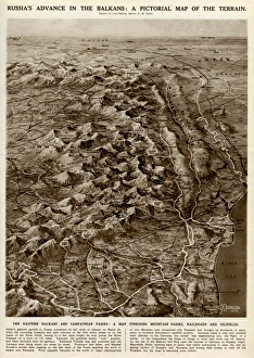
Russian advance in Balkans by G. H. DavisRussias advance in the Balkans during the Second World War: a pictorial map of the terrain. The Eastern Balkans and Carpathian passes: a map showing mountain passes, railways and oilfields. Date: 1944
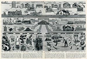
By-products developed from coal by G. H. DavisThe enormous importance of coal as the basic element in vital war manufactures. A diagrammatic drawing showing a great variety of by-products developed from coal. Date: 1944
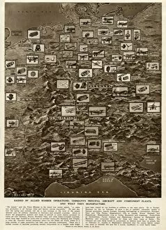
German plants raided by Allied bombing, by G. H. DavisRaided by Allied bomber operations during the Second World War: Germanys principal aircraft and component plants, and what they manufacture. Date: 1944
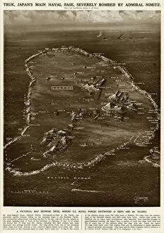
Truk naval base by G. H. DavisA pictorial map of Truk, Japans main naval base, severely bombed by Admiral Nimitz, Commander-in-Chief of the US Navy in the Pacific
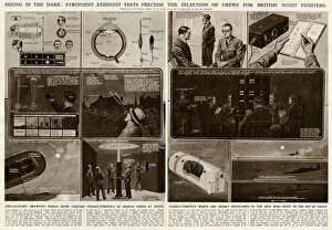
Crews for British night fighters by G. H. DavisSeeing in the dark: stringent eyesight tests precede the selection of crews for British night fighters during the Second World War. The men selected have highly developed vision. Date: 1944
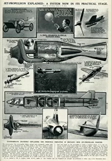
Jet propulsion explained by G. H. DavisJet propulsion explained: a system in its practical stage at this phase of the Second World War. Drawings explaining the principle employed in Britains new jet-propelled fighter aircraft. 1944
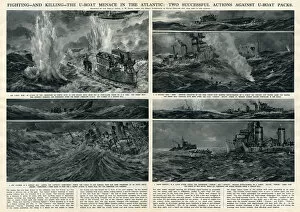
Actions against U-boats in Atlantic by G. H. DavisTwo successful actions against German U-boats in the Atlantic during the Second World War. Date: 1944
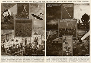
Searchlight command by G. H. DavisSearchlight command: the men who point the way for Britains anti-aircraft guns and night fighters during the Second World War
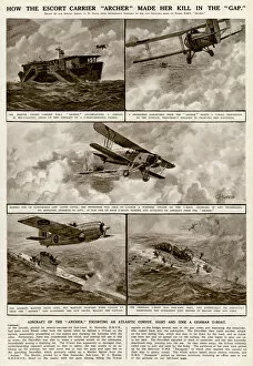
Escort carrier Archer by G. H. DavisHow the escort carrier Archer made her kill in the gap during the Second World War. The aircraft of the Archer, escorting an Atlantic convoy, sight and sink a German U-boat. Date: 1943
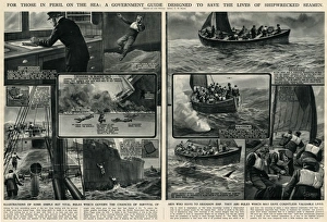
Life saving guide for seamen by G. H. DavisFor those in peril on the sea: a Government guide designed to save the lives of shipwrecked seamen during the Second World War
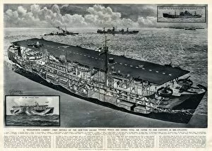
New type of escort vessel by G. H. DavisA Woolworth Carrier: first details of the new type of escort vessel giving vital air cover to British convoys in mid-Atlantic during the Second World War. Date: 1943
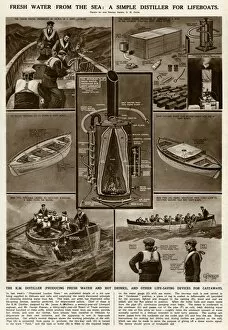
Water distiller for lifeboats by G. H. DavisFresh water from the sea: a simple distiller for lifeboats. The K.M. Distiller, producing fresh water and hot drinks, and other life-saving devices for castaways, in use during the Second World War
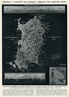
Map of Sardinia by G. H. DavisA contour map of Sardinia, showing airfields and seaplane bases during the Second World War. The island was experiencing concentrated bombing by the Allied Strategic Air Force. Date: 1943