mail_outline sales@mediastorehouse.com
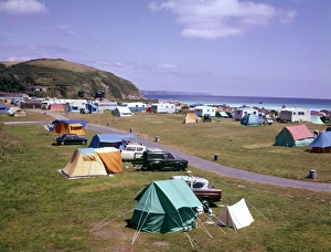
Caravan park, Mevagissey, CornwallCars and tents at the Pentewan caravan park, near Mevagissey, Cornwall. Date: 1960s
European coastline 1944A double page spread of The Illustrated London News, published less than a month before the Allied D-Day Normandy landings
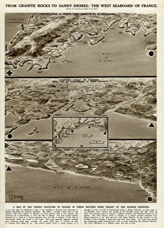
West seaboard of France by G. H. DavisA supplementary illustration to that which had appeared in the previous issue of The Illustrated London News (picture 10948123)
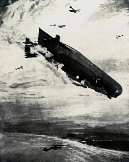
WW1 - Commodore Bigsworth drops bombs on zeppelin, 1915WW1 - Air Commodore Arthur Wellesley Bigsworth (1885-1961) was a pioneer aviator who had a distinguished military career in the service of the British armed forces
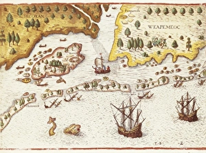
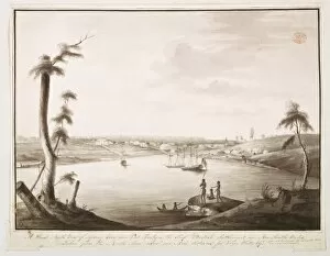
BRY, Theodor de (1528-1598). Arrival of the English in Virginia in 1607. Detail of map in Admiranta Narratio. 1590- 1634. Engraving. FRANCE. Ό E-DE-FRANCE. Paris
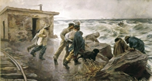
Ferrer Calatayud, PedroFERRER CALATAYUD, Pedro (1870-1944). Rescuing a shipwrecked. 1895. Realism. Oil on canvas. SPAIN. Valencia. San Pio V Fine Arts Museum
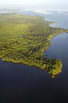
Sulu Sea and rainforest on shore near Sandakan. helicopter view; Sabah, Borneo, Malaysia; morning in June
Wooden Propeller painted with either an RE8 or a BE2E on a spotting and reconnaissance mission leaving English coastline over the North Sea.. J. Willey J
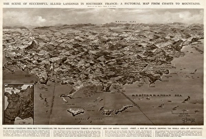
Allied landings in southern France by G. H. DavisThe scene of successful Allied landings in southern France during the Second World War: a pictorial map from coasts to mountains. Date: 1944
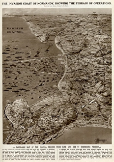
Invasion coast of Normandy by G. H. DavisThe invasion coast of Normandy, showing the terrain of operations during the Second World War. A panoramic map of the coastal regions from Cap Gris Nez to the Cherbourg Peninsula. Date: 1944
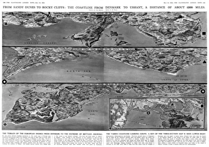
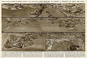
Coastline from Denmark to Ushant by G. H. DavisFrom sandy dunes to rocky cliffs: the coastline from Denmark to Ushant (Brittany), a distance of about 1200 miles. The terrain of the European shores from Denmark to the extreme of Brittany
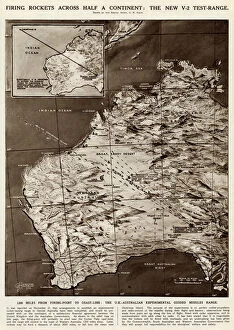
Rocket firing tests by G. H. DavisFiring rockets across half a continent: the new V2 test range. The UK-Australian experimental guided missiles range, with 1200 miles from firing point to coastline
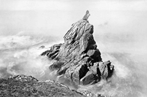
Bishops Rock, Isles of ScillyRocky outcrop off the coast called Bishops Rock - St Agnes, Isles of Scilly Date: circa 1890s
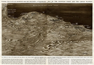
Map of Egyptian coast and Libyan plateau by G. H. DavisWhere the fate of mankind may be decided: a panoramic map of the Egyptian coast and the Libyan plateau. The theatre of war in the Middle East during the Second World War
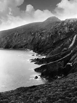
Carmarthenshire CoastThe rocky coast at Pembrey, near Burry Port, Carmarthenshire, Wales. Date: 1930s
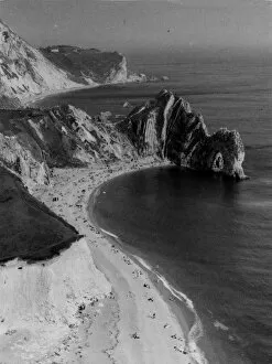
Dorset CoastlineA striking impression of the Dorset (England) coastline, with its cliffs and sands, seen here at Durdle Dor, a fine cliff formation, with an arched rock. Date: 1950s
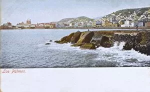
Canary Island, Gran Canaria, Las Palmas, Panoramic view Date: 1906
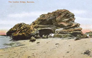
The London Bridge rocks, Sorrento, Victoria, AustraliaThe weathered London Bridge sandstone rock formation at Sorrento, Mornington Peninsula, Victoria, Australia Date: circa 1907
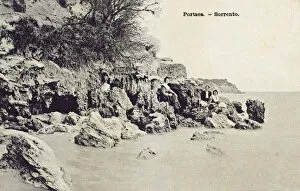
Sitting on rocks at Portsea, Sorrento, Victoria, AustraliaSitting on rocks at Portsea, Sorrento, Mornington Peninsula, Victoria, Australia Date: circa 1911
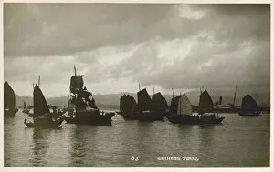
A fleet of Chinese junks - at dusk Date: 1920s
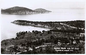
Istanbul, Turkey - Princes Island - BuyukadaIstanbul, Turkey - Princes Islands - Buyukada - the largest of the nine islands (a place of exile for the Byzantine Empresses). Today, the rich inhabitants of Istanbul have their summerhouses here
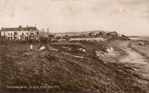
Seascale, Cumbria - View from the North Date: circa 1920
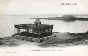
France - St Malo - The Emerald Coast - Tomb of Chateaubriand. FrancO© s-Renevicomte de Chateaubriand (17681848) was a French writer, politician, diplomat and historian
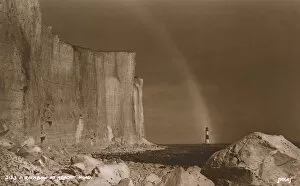
A Rainbow over the sea at Beachy Head, Kent. Date: circa 1915
Misty Evening over the Sussex coastline. Date: circa 1912
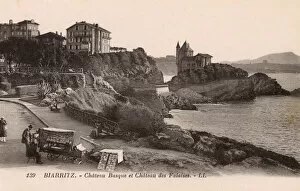
Biarritz, France - Chateau Basque and Chateau des Falaises and (even more importantly!) a lovely postcard seller and his mobile stall! Date: circa 1910
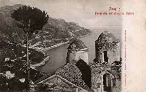
Ravello - Italy - View from the Rufolo GardenView from the Rufolo Garden - Ravello, Italy. The enchantment of Villa Rufolo reaches its peak in this famous garden loved by Wagner. Date: circa 1902
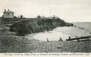
High Tide damage at Gunhill, Southwold - October and November 1905. Date: 1905
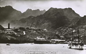
General view of the Seaport of Aden, Yemen from the sea Date: circa 1920s
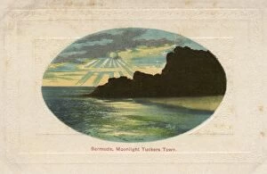
Moonlight over Tuckers Town, Bermuda Date: circa 1909
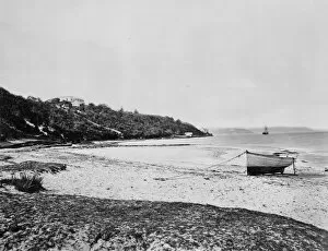
Coral Beach - South Shore, Bermuda - Western Atlantic Date: circa 1910s
Convair XC-99 cruising along the Californian coastline
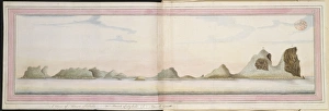
Drawing 22 from the Watling Collection
A View of the coastline on the western side of Lord Howe IslDrawing LS 5 from the Watling Collection titled View of Lord Howe Island by a Port Jackson Painter, 1788-1797
Healing a childWatercolour 45 by the Port Jackson Painter from Banks Manuscript 34, (c. 1790)
View of Sydney Cove from the North shore of the harbourDrawing LS 7 from the Watling Collection titled A Direct North View of Sydney Cove and Port Jackson, the Chief British Settlement in New South Wales by Thomas Watling, 1792-1797
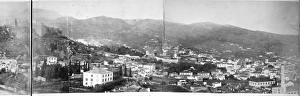
Panoramic: Landscape in Madeira 1873A photograph taken during the voyage of H.M.S. Challenger (1872-1876), funded by the British Government for scientific purposes
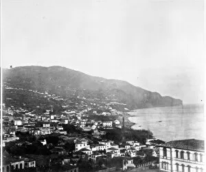
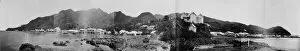
Funchal, Madeira 1873A photograph taken during the voyage of H.M.S. Challenger (1872-1876), funded by the British Government for scientific purposes
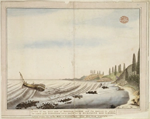
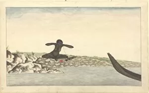
Mr. Waterhouse endeavouring to break the Spear after Govr PhDrawing 24 from the Watling Collection - Mr. Waterhouse endeavouring to break the Spear after Govr Phillips was wounded by Wil-le-me-ring where the Whale was cast on shore in Manly Cove
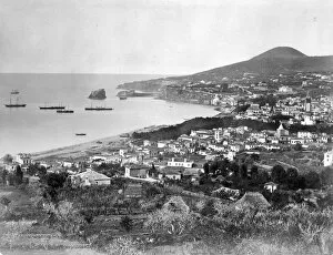
Port in Madeira 1873A photograph taken during the voyage of H.M.S. Challenger (1872-1876), funded by the British Government for scientific purposes
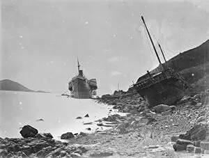
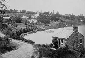
Beached paddle steamer. ChinaA photograph taken during the voyage of H.M.S. Challenger (1872-1876) funded by the British Government for scientific purposes
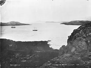
Island Harbour, Kerguelen IslandA photograph taken during the voyage of H.M.S. Challenger (1872-1876) funded by the British Government for scientific purposes
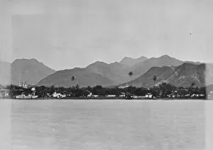
Bahia roadside view, Brazil, South America 1873A photograph taken during the voyage of H.M.S. Challenger (1872-1876), funded by the British Government for scientific purposes
Darling Point, Sydney, AustraliaA photograph taken during the voyage of H.M.S. Challenger (1872-1876) funded by the British Government for scientific purposes
Elizabeth Bay, view across beach from Darling Point. SydneyA photograph taken during the voyage of H.M.S. Challenger (1872-1876) funded by the British Government for scientific purposes
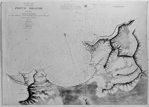
Chart of Roadstead, Porto Grande, St. Vincent, Madeira, PortA photograph taken during the voyage of H.M.S. Challenger (1872-1876) funded by the British Government for scientific purposes
Panoramic: Levuka, Ovalau Island, FijiA photograph taken during the voyage of H.M.S. Challenger (1872-1876) funded by the British Government for scientific purposes
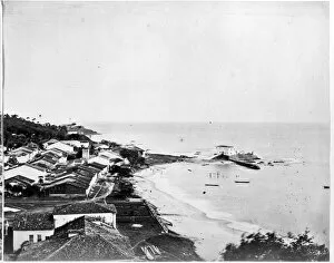
Honolulu from the new wharf. Honolulu, Oahu, HawaiiA photograph taken during the voyage of H.M.S. Challenger (1872-1876) funded by the British Government for scientific purposes