mail_outline sales@mediastorehouse.com
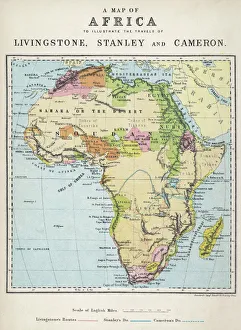
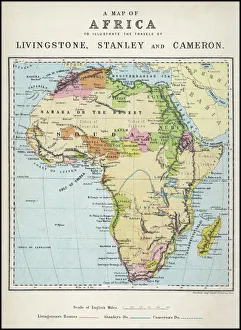
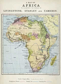
Map of Africa illustrating travels of explorersA map of Africa which illustrates the travels of the explorers Livingstone, Stanley and Cameron
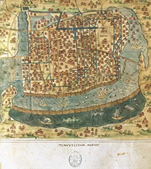
Map of Tenochtitlan. Mexico, 1560. By Alonso de Santa CruzMap of Tenochtitlan. Mexico, 1560. General islario of all the islands in the world. Work of the chronicler and cosmographer Alonso de Santa Cruz (1505-1567). National Library. Madrid. Spain
Map of Africa illustrating travels of explorersA map of Africa which illustrates the travels of Livingstone, Stanley and Cameron. Date: 19th Century
Map of Greek island of Corfu. Ionian Sea. Italian map. 1537
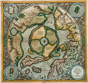
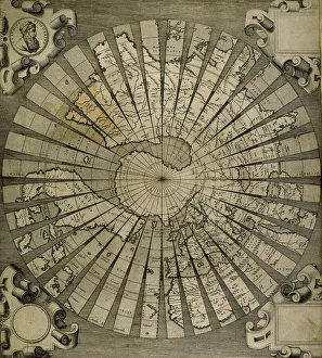
Septentrionalium Terrarum descriptio, 1595, by Gerardus MercGerardus Mercator (1512-1594). Flemish cartographer. Septentrionalium Terrarum descriptio. Map of the Arctic with the North Pole and surrounding lands within and outside the Arctic Circle, 1595
Dubrovnik. Map of the city before the earthquake of 1667. Croatia
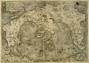
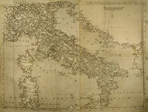
Map of Italian Peninsula, Islands of Corsica and Sardinia and Adriatic coast. Engraving. 16th century
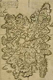
Map of Corsica. Italian engraving. 16th century
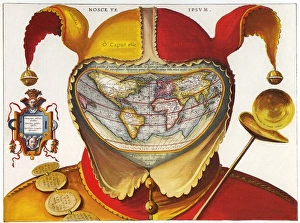
16th century red and yellow Jesters Cap costume map of the world16th century Jesters Cap map of the world 1590
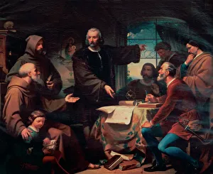
Christopher Columbus at La Rabida, 1872. By F. AdamChristopher Columbus (1451-1506). Genoese navigator. Columbus at the Convent of La Rabida, 1872. Copy by F. Adam of the homonimous painting by Eduardo Cano de la Pena. Maritime Museum. Barcelona
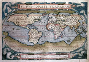
Theatrum Orbis Terrarum (Theatre of the World) by Abraham OrTheatrum Orbis Terrarum (Theatre of the World). Is considered to be the first true modern atlas. Written by Abraham Ortelius and originally printed on May 20, 1570, in Antwerp. World Map
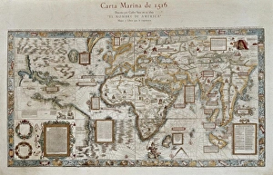
Carta marina (map of the sea). 1516. Facsimile" Carta marina (map of the sea). 1516. Facsimile. Sea map described by Carlos Sainz in his work " The name of America". Engraving. SPAIN. Madrid. Americas Museum."
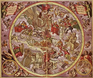
Andreas Cellarius (1596-1665). Dutch-German cartographer. Harmonia Macrocosmica, 1660, a major star atlas, published by Johannes Janssonius in Amsterdam
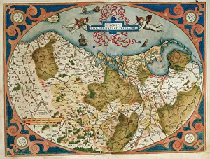
Map of Germany and current Netherlands. Theatrum Orbis Terrarum by Abraham Ortelius (1527-1598). First Edition. Antwerp, 1574. Library of Catalonia. Barcelona. Spain
Austria. Vienna. Plan, 1720Austria. Vienna. Plan of the walled city with Prater and the Danube River. Engraving, 1720
Spain. Castile and Leon. Burgos. Map, 1576 at Civitates Orbis Terrarum by Georg Braun (1541-1622) and Franz Hogenberg (1536-1590). Salamanca University Library
World map by Claudius Ptolemy (90-168). Engraving, 16th centClaudius Ptolemy (90-168) Greco-Egyptian geographer. World map. Engraving, 16th century
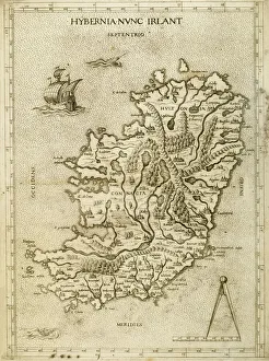
Hybernia Nunc Irlant. Ireland. Map was clearly made by a member of the Lafreri School of cartographers, Antonio Lafreri (1512-77). Rome, 1570. Renaissance. Engraving by Paolo Forlani, 16th C
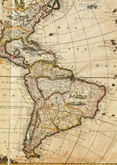
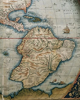
Map of America. Nova Totius Americae Descriptio by FrederikNova Totius Americae Descriptio. Map of America. By Frederik de Wit (1630-1706). Amsterdam, 1666
Barcelona (19th c. ). Geometrical map, by Jos項Barcelona (19th c.). Geometrical map, by Jos頍 as y Vila. SPAIN. Barcelona. Historical Archive of Barcelona
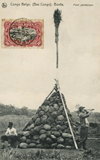
Trigonometry PointA Trigonometry Point at Buvita in the Belgium Congo, topped off with a broom!
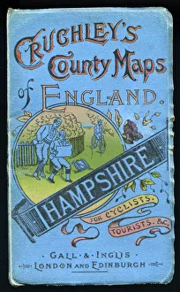
Cover design, county map of Hampshire for cyclists and tourists, in a series entitled Cruchleys County Maps of England, published by Gall & Inglis of London and Edinburgh. Date: early 20th century
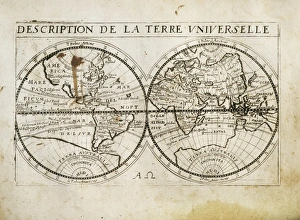
Description de la Terre Universelle (1667). Map. Engraving
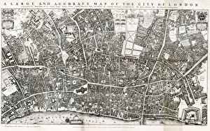
Map of the City of London by John Ogilby 1676. Ogilby (also Ogelby, Oglivie - 16001676) was a Scottish translator, impresario and cartographer
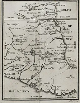
Map of the territory of New Spain. Historia de la Conquista de Mexico, poblacion, y progresos de la America septentrional, conocida por el nombre de Nueva Espana (History of the Conquest of Mexico)
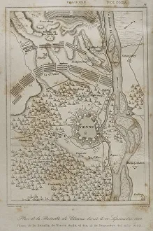
Plan of the Battle of Vienna, 12 September 1683Holy Roman Empire. Plan of the Battle of Vienna, 12 September 1683. It took place at Kahlenberg Mountain, near Vienna, ather the city had been besieged by the Ottoman Empire during two months
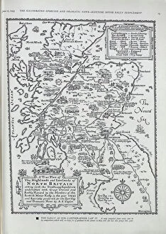
Map of Scottish Car RallyA map by A. E. Taylor showing the itinerary and some of the incidents of the Scottish Motor Rally of 1933. Date: 1933
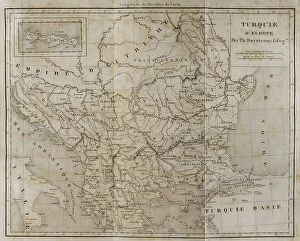
European Turkey map by Th. DuvotenayEuropean Turkey map by Thunot Duvotenay. Historia de Turquia by Joseph Marie Jouannin (1783-1844) and Jules Van Gaver, 1840. Date: 2018
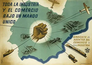
Spanish Civil War (1936-1939). Toda la industria y el comercio bajo un mando unico (All the industry and trade under an only rule)
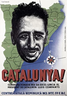
Spain (20th c. ). Civil War. Catalunya! (Catalonia!)Spain (20th c.). Civil War. Catalunya! (Catalonia!). Poster by Ricard Giralt Miracle with the portrait of Lluis Companys. SPAIN. Salamanca. Archivo Historico Nacional
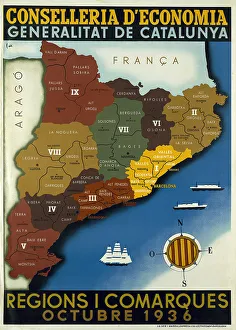
Spanish Civil War Map Of Catalonia Regions Andspanish, civil, war, map, of, catalonia, regions, and, counties, october, poster, edited, by, the, regional, ministry, ecocomy, generalitat, spain, barcelona, biblioteca, de, catalunya, national
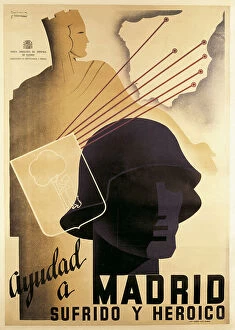
Spainish Civil War (1936-1939). Ayudad a Madrid sufrido y heroico (Help the suffering and heroic Madrid). Poster by Cabana y Contreras. SPAIN. Barcelona
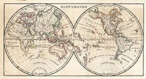
Map of the world circa 1810. Handcoloured copperplate engraving by Andrea Bernieri from Giulio Ferrarios Ancient and Modern Costumes of all the Peoples of the World, Florence, Italy, 1843
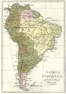
Map of South America, 1842. Handcoloured copperplate engraving after a chart by Ab. B. Berghi from Giulio Ferrrarios Costumes Antique and Modern of All Peoples
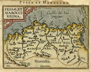
Map of Morocco, 1601Map of Morocco, north, africa, african, 1601. 1601
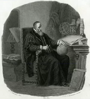
DUTCH MAP MAKERA Dutch map maker sits at his desk studying a globe, with a pair of compasses in his hand
Map of Africa illustrating travels of explorersA map of Africa which illustrates the travels of the explorers Livingstone, Stanley and Cameron. Date: 19th Century
Map of Central and South America. Theatrum Orbis Terrarum by Abraham Ortelius (1527-1598). First Edition. Antwerp, 1574
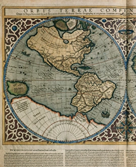
World Map by Rumold Mercator (1512-1594)Orbis Terrae Compendiosa Descriptio. World map, 1587. Detail of America. By Rumold Mercator (1545-1599)
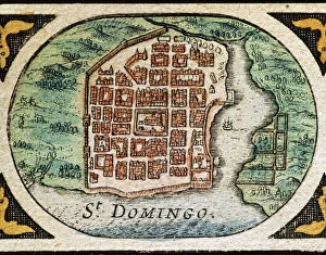
Santo Domingo (Dominican Republic). Hispaniola. Map in 1646
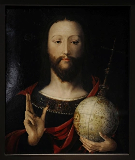
Salvator Mundi, 1537-1545Salvator Mundi. Christ with the Globe. 1537-1545. Lower Rhin. German Historical Museum. Berlin. Germany
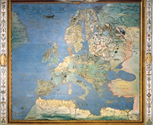
ITALY. Caprarola. Villa Farnese. Map of Europe. 1574 painting by Giovanni Antonio da Varese Vanosino. Stanza del Mappamondo (Geographic room or Room of the World Map). Renaissance art. Cinquecento
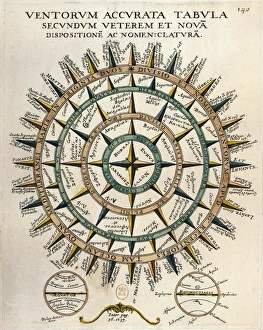
Tabula secundum accurata Ventorum veterem et nova [m] dispositione [m] ac nomenclature [m] (Table of the winds according to the old and new layout and nomenclature)
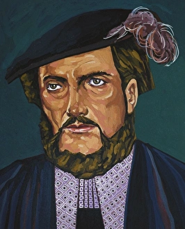
Portrait of Amerigo Vespucci AnonymousVESPUCCI, Amerigo (1454-1512). Italian explorer and cartography; generally considered that the continents of America named after him. Oil
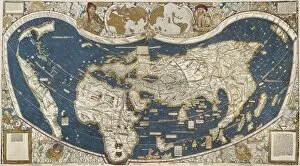
Universal Map, belonging to the work Cosmographiae" Universal Map, belonging to the work " Cosmographiae "
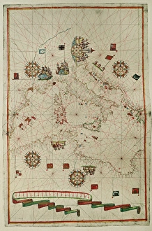
Portolan atlas by Joan Martines (1556-1590). WesternPortolan atlas of the world by Joan Martines (1556-1590). Messina, 1587. Western Mediterranean. National Library. Madrid. Spain
Map showing Auckland & the River Waikato, New Zealand, 1863Map of the country between Auckland and the River Waikato, New Zealand, illustrating the war with the native Maori tribes. Date: 1863
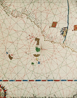
Portolan of Joan Martines (16th century). 1587. Map of the CPortolan of Spanish cartographer Joan Martines (16th century). Majorcal school. 1587. Map of the Canary Islands and the west coast of Africa. Messina, Sicily. National Library. Madrid. Spain