mail_outline sales@mediastorehouse.com
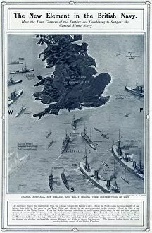
New element in British Navy by G. H. DavisThe new element in the British Navy: how the four corners of the Empire are combining to support the central Home Navy. Showing how Canada, Australia
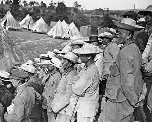
Chinese troops in France, Western Front, WW1Chinese troops near the Western Front in France during World War One, taking a break to watch a dragon fight. Date: circa 1916
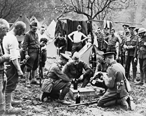
British and American troops playing cards, WW1British and American troops enjoying a game of cards on the Western Front in France during World War One. Date: circa 1916
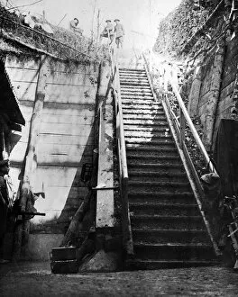
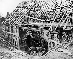
Entrance to captured German dugout, Western Front, WW1Entrance to a captured German dugout on the Western Front during World War One. Date: circa 1916
American infantry on French road, Western Front, WW1American infantry marching along a French road on the Western Front during World War One. Date: circa 1916
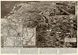
Contour map of Western Front by G. H. DavisThe Western Front: a contour map showing the area of the general Allied offensive at this stage of the Second World War. Showing the Siegfried Line, the supply port of Antwerp
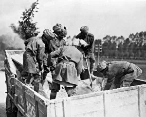
Indian soldiers repairing roads in France, WW1Indian soldiers repairing roads on the Western Front in France during World War One. Date: circa 1916
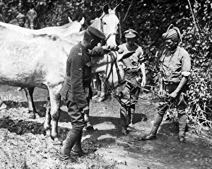
Indian soldier watering mules, Western Front, WW1An Indian soldier watering mules on the Western Front in France during World War One. Date: circa 1916
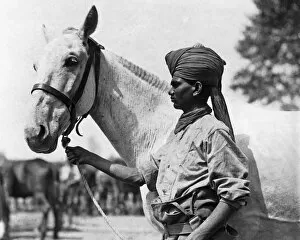
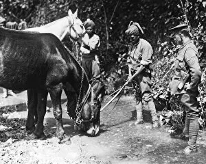
Indian soldier with horse, Western Front, WW1An Indian soldier with his well-groomed horse on the Western Front in France during World War One. Date: circa 1916
Indian soldiers watering mules, Western Front, WW1Indian soldiers watering mules on the Western Front in France during World War One. Date: circa 1916
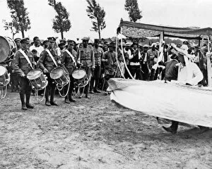
Chinese troops on Western Front in France, WW1Chinese troops on the Western Front in France during World War One. They are celebrating a dragon day with a Chinese boat display. Date: circa 1916
Captured German gun on Western Front, WW1A German 8-inch gun captured by Highlanders on the Western Front in France during the Cambrai Offensive, World War One. Date: circa 1916
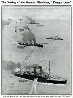
Sinking of German ship, Konigin Luise, by G. H. DavisThe sinking of the German mine layer, Konigin Luise, off Harwich in the early stages of the First World War. Showing the position of the Lance when firing the three fatal shots. Date: August 1914
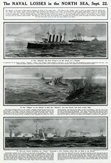
Naval losses in North Sea by G. H. DavisThe naval losses in the North Sea, all on the same day. (1) The Aboukir, struck by a German torpedo. (2) The Hogue, struck and sunk while trying to help the Aboukir
Military radar in wartime by G. H. DavisMilitary radar: how this vital secret weapon helped the Allied land forces to achieve final victory during the Second World War. Date: 1945
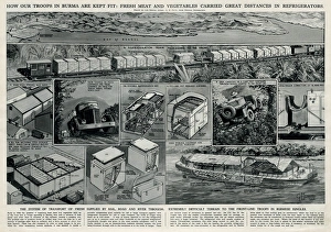
Allied troops in Burma by G. H. DavisHow the Allied troops in Burma are kept fit: fresh meat and vegetables carried great distances in refrigerators. Showing the system of transport of fresh supplies by rail
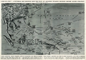
Map of Japanese invasion receding by G. H. DavisA pictorial map of the Pacific area, showing how the wave of Japanese invasion receded as a result of the Allied strategy during the Second World War
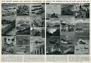
British science and ingenuity in war by G. H. DavisHow British science and ingenuity contributed to the defeat of the Germans at sea, on land, and in the air. A few of the many weapons, devices and tactics, both offensive and defensive
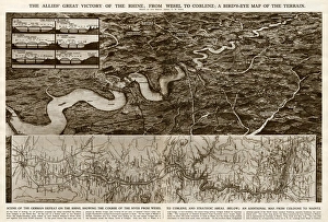
Allies victory of the Rhine by G. H. DavisThe Allies victory of the Rhine during the Second World War: from Wesel to Coblenz. A birds eye map of the terrain, with an additional map from Cologne to Mainz. Date: 1945
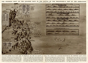
Battle of the Philippines by G. H. DavisThe crushing rout of the Japanese Navy in the Battle of the Philippines during the Second World War. A map of the operations
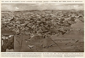
Allied landings in southern France by G. H. DavisThe scene of successful Allied landings in southern France during the Second World War: a pictorial map from coasts to mountains. Date: 1944
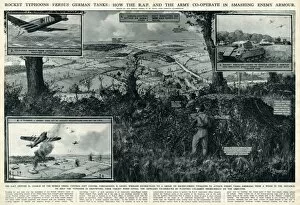
RAF and Army cooperate against enemy by G. H. DavisRocket typhoons versus German tanks: how the RAF and the Army cooperate in smashing enemy armour during the Second World War
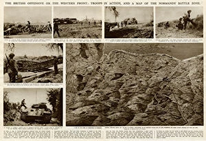
British offensive on Western Front by G. H. DavisThe British offensive on the Western Front during the Second World War: troops in action, and a map of the Normandy battle zone. Date: 1944
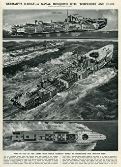
Germanys E-boat by G. H. DavisGermanys E-boat -- a naval mosquito with torpedoes and guns, in use during the Second World War. The craft which Germany hoped would help disorganise the Allied invasion fleet. Date: 1944
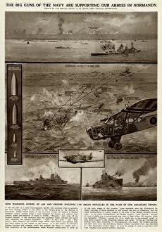
Naval support for armies in Normandy by G. H. DavisThe big guns of the Royal Navy supporting the Allied armies in Normandy during the Second World War. How warships, guided by air and ground spotters
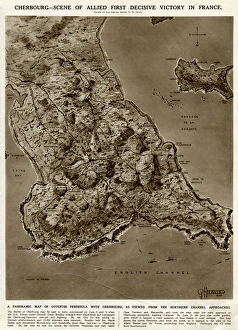
Cherbourg, scene of victory, by G. H. DavisCherbourg -- scene of Allied first decisive victory in France during the Second World War. A panoramic map of Cotentin Peninsula with Cherbourg, as viewed from the northern Channel approaches
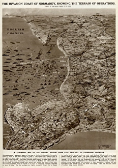
Invasion coast of Normandy by G. H. DavisThe invasion coast of Normandy, showing the terrain of operations during the Second World War. A panoramic map of the coastal regions from Cap Gris Nez to the Cherbourg Peninsula. Date: 1944
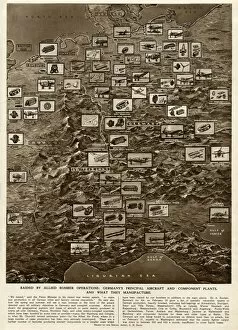
German plants raided by Allied bombing, by G. H. DavisRaided by Allied bomber operations during the Second World War: Germanys principal aircraft and component plants, and what they manufacture. Date: 1944
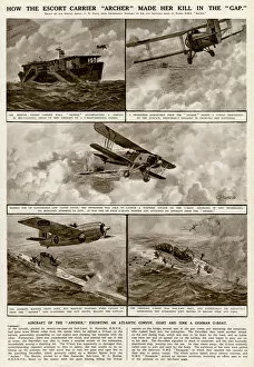
Escort carrier Archer by G. H. DavisHow the escort carrier Archer made her kill in the gap during the Second World War. The aircraft of the Archer, escorting an Atlantic convoy, sight and sink a German U-boat. Date: 1943
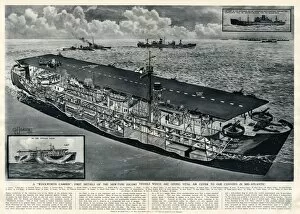
New type of escort vessel by G. H. DavisA Woolworth Carrier: first details of the new type of escort vessel giving vital air cover to British convoys in mid-Atlantic during the Second World War. Date: 1943
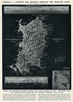
Map of Sardinia by G. H. DavisA contour map of Sardinia, showing airfields and seaplane bases during the Second World War. The island was experiencing concentrated bombing by the Allied Strategic Air Force. Date: 1943
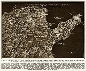
Map of Tunisia by G. H. DavisMap of the Front Zone in Tunisia, North Africa, immediately prior to the capture of Mateur, opening the road to Tebourba and Djedeida for Allied forces during the Second World War. Date: 1943
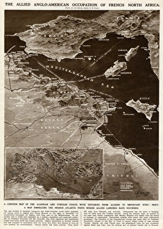
Allied occupation of French North Africa by G. H. DavisThe Allied Anglo-American occupation of French North Africa during the Second World War. A contour map of the Algerian and Tunisian coasts, with distances from Algiers to important sites
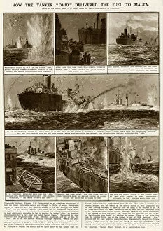
Tanker Ohio with fuel for Malta by G. H. DavisHow the tanker Ohio delivered fuel to Malta during the Second World War, in the face of numerous enemy attacks. Date: 12-14 August 1942
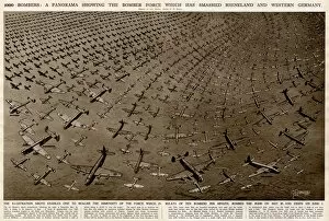
Bomber force panorama by G. H. Davis1000 bombers: a panorama showing the Allied bomber force which attacked the Rhineland and Western Germany, at the rate of ten bombers per minute
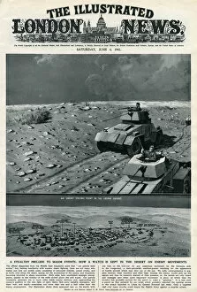
German strong point in Libyan desert by G. H. DavisA German strong point in the Libyan desert during the Second World War. A stealthy prelude to major events: how a watch is kept by the Allies on enemy movements. Date: 1942
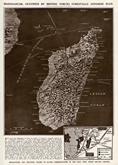
Madagascar strategic island by G. H. DavisMadagascar, the strategic island to Allied communications in the East, occupied by British forces, forestalls a Japanese plot during the Second World War
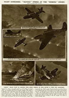
Havoc aircraft shoot down enemy bombers by G. H. DavisNight intruders during the Second World War: Havocs (the renamed Douglas Boston) strike at German bombers returning home. Date: 1942
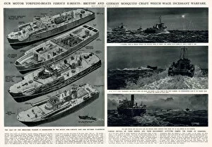
Motor torpedo boats v. E-boats by G. H. DavisBritish motor torpedo boats versus German E-boats: British and German mosquito (miniature) craft which wage incessant warfare during the Second World War. Date: 1942
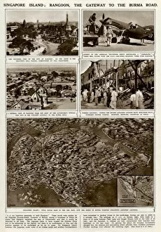
Singapore island, vital naval base, by G. H. DavisSingapore island: Rangoon, the gateway to the Burma Road during the Second World War. The island was a vital Allied naval base in the Far East
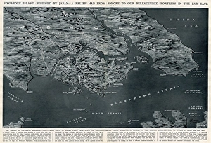
Singapore besieged by Japan, by G. H. DavisSingapore island besieged by Japan during the Second World War: a relief map from Johore to the beleaguered fortress in the Far East where the defending British forces retreated on 31 January 1942
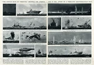
Thrilling Mediterranean feat by G. H. DavisThe convoy must go through, ordered the admiral -- and it did. Story of a thrilling Mediterranean feat during the Second World War
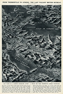
British retreat from Thermopylae to Athens by G. H. DavisFrom Thermopylae to Athens: the last valiant British retreat. A relief map looking southwards, showing the last stages of a glorious rearguard action during the Battle of Greece, Second World War
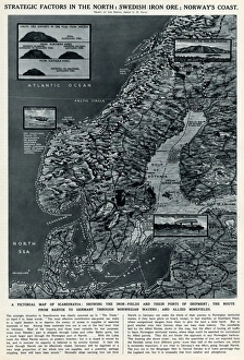
Strategic factors in the north by G. H. DavisStrategic factors in the north: Swedish iron ore; Norways coast. A pictorial map of Scandinavia, showing the iron fields and their ports of shipment
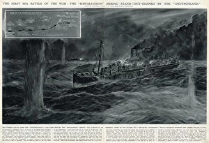
Rawalpindi outgunned by Deutschland by G. H. DavisThe first sea battle of the Second World War: the British armed merchant cruiser Rawalpindis heroic stand, outgunned by the Deutschland
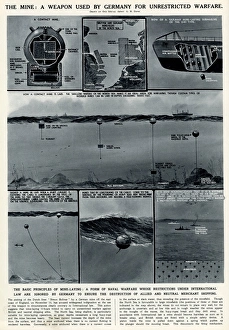
The mine used by Germany by G. H. DavisThe mine: a weapon used by Germany for unrestricted warfare. The basic principles of mine laying: a form of naval warfare whose restrictions under international law are ignored by Germany to ensure
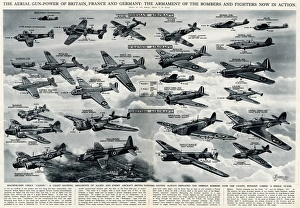
Aerial gunpower in 1940 by G. H. DavisThe aerial gunpower of Britain, France and Germany: the armament of the bombers and fighters now in action. Machine gun versus canon
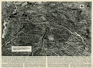
Wartime map of Berlin by G. H. DavisA map of Berlin during the Second World War, explaining why the German capital city is the focus of RAF bombing, showing the main war industries, transport centres and power stations. Date: 1943