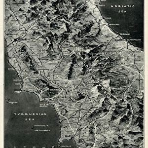
Wartime map of Berlin by G. H. Davis

![]()
Wall Art and Photo Gifts from Mary Evans Picture Library
Wartime map of Berlin by G. H. Davis
A map of Berlin during the Second World War, explaining why the German capital city is the focus of RAF bombing, showing the main war industries, transport centres and power stations. Date: 1943
Media ID 14132347
© Illustrated London News Ltd/Mary Evans
1943 Allied Allies Areas Berlin Bombing Capital Centres Davis Districts Focus Industries Main Power Stations
MADE IN THE UK
Safe Shipping with 30 Day Money Back Guarantee
FREE PERSONALISATION*
We are proud to offer a range of customisation features including Personalised Captions, Color Filters and Picture Zoom Tools
SECURE PAYMENTS
We happily accept a wide range of payment options so you can pay for the things you need in the way that is most convenient for you
* Options may vary by product and licensing agreement. Zoomed Pictures can be adjusted in the Basket.