
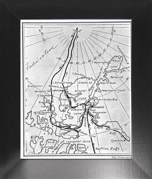
Framed Print : Map showing Dr. Frederick Cooks route to the North Pole, 19


![]()
Framed Photos from Mary Evans Picture Library
Map showing Dr. Frederick Cooks route to the North Pole, 19
Map showing the route taken by Dr. Frederick A. Cook and his Inuit companions, Ah-welsh and Etukishook, to the North Pole, in 1907 - 1908. The chart has been signed by the doctor, at top left. A debate has long raged over whether it was Cook or Peary who first reached the North Pole, but it seems that Dr. Cook had a good claim to be first
Media ID 4385835
© Illustrated London News Ltd/Mary Evans
Chart Claim Companions Cook Debate Doctor Frederick Good Inuit Peary Pole Reached Route Signed
12"x10" Modern Frame
10x8 Print in an MDF Wooden Frame with 180 gsm Satin Finish Paper. Glazed using shatter proof thin plexi glass. Frame thickness is 1 inch and depth 0.75 inch. Fluted cardboard backing held with clips. Supplied ready to hang with sawtooth hanger and rubber bumpers. Spot clean with a damp cloth. Packaged foam wrapped in a card.
Contemporary Framed and Mounted Prints - Professionally Made and Ready to Hang
Estimated Image Size (if not cropped) is 25.4cm x 25.4cm (10" x 10")
Estimated Product Size is 25.4cm x 30.5cm (10" x 12")
These are individually made so all sizes are approximate
Artwork printed orientated as per the preview above, with landscape (horizontal) or portrait (vertical) orientation to match the source image.
MADE IN THE USA
Safe Shipping with 30 Day Money Back Guarantee
FREE PERSONALISATION*
We are proud to offer a range of customisation features including Personalised Captions, Color Filters and Picture Zoom Tools
FREE COLORIZATION SERVICE
You can choose advanced AI Colorization for this picture at no extra charge!
SECURE PAYMENTS
We happily accept a wide range of payment options so you can pay for the things you need in the way that is most convenient for you
* Options may vary by product and licensing agreement. Zoomed Pictures can be adjusted in the Cart.