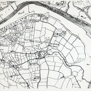
Colliery map of Hook, Pembrokeshire, South Wales

![]()
Wall Art and Photo Gifts from Mary Evans Picture Library
Colliery map of Hook, Pembrokeshire, South Wales
A colliery map (by Thomas Lewis) of the village of Hook, described here as West Hook in the parish of Langwn (Llangwm), showing fields, trees and mining locations. Hook is on the Western Cleddau near Haverfordwest, Pembrokeshire, South Wales
Media ID 4474289
© Mary Evans / Roger Worsley Archive
1770s 1776 Cleddau Coal Mine Colliery Estuary Fields Haverfordwest Hook Lewis Llangwm Maps Mine Mining Parish Pembrokeshire
MADE IN THE UK
Safe Shipping with 30 Day Money Back Guarantee
FREE PERSONALISATION*
We are proud to offer a range of customisation features including Personalised Captions, Color Filters and Picture Zoom Tools
SECURE PAYMENTS
We happily accept a wide range of payment options so you can pay for the things you need in the way that is most convenient for you
* Options may vary by product and licensing agreement. Zoomed Pictures can be adjusted in the Basket.