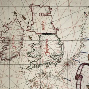
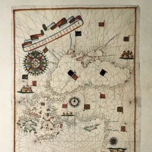
A map of Britain, mid 16th century

![]()
Wall Art and Photo Gifts from Mary Evans Picture Library
A map of Britain, mid 16th century
A map of Britain in the mid 16th century, detailing Edinburgh, Dover, Cornwall, Waterford and London. Date: Mid 16th century
Media ID 14221391
© Mary Evans Picture Library
1550s Dover Edinburgh Hibernia Places Scotia Waterford
MADE IN THE UK
Safe Shipping with 30 Day Money Back Guarantee
FREE PERSONALISATION*
We are proud to offer a range of customisation features including Personalised Captions, Color Filters and Picture Zoom Tools
FREE COLORIZATION SERVICE
You can choose advanced AI Colorization for this picture at no extra charge!
SECURE PAYMENTS
We happily accept a wide range of payment options so you can pay for the things you need in the way that is most convenient for you
* Options may vary by product and licensing agreement. Zoomed Pictures can be adjusted in the Basket.