mail_outline sales@mediastorehouse.com
India - Rungazes dyers, Shepherd and Robertson, 1860s19th century vintage photograph India - Rungazes dyers Shepherd and Robertson, 1860s
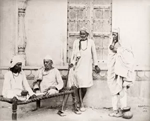
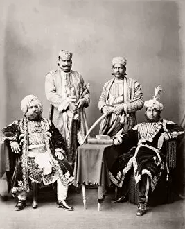
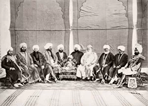
India - Jemandars and Lambardars 1860s19th century vintage photograph India - Jemandars and Lambardars Shepherd and Robertson, 1860s
India - Sadhs Fakirs, Shepherd and Robertson, 1860s19th century vintage photograph India - Sadhs Fakirs Shepherd and Robertson, 1860s
India - Brahmins, Shepherd and Robertson, 1860s19th century vintage photograph India - Brahmins Shepherd and Robertson, 1860s
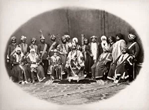
India - Nawabs, Shepherd and Robertson, 1860s19th century vintage photograph India - Nawabs Shepherd and Robertson, 1860s
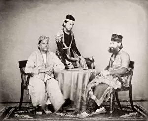
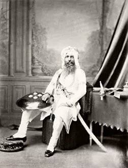
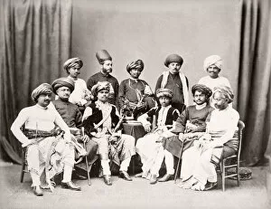
India - Moguls, Shepherd and Robertson, 1860s19th century vintage photograph India - Moguls Shepherd and Robertson, 1860s
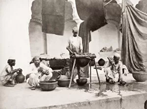
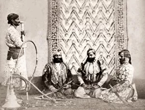
India - Gujur Sirdars, Shepherd and Robertson, 1860s19th century vintage photograph India - Gujur Sirdars Shepherd and Robertson, 1860s
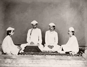
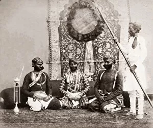
India - Jat Sirdars, Shepherd and Robertson, 1860s19th century vintage photograph India - Jat Sirdars Shepherd and Robertson, 1860s
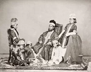
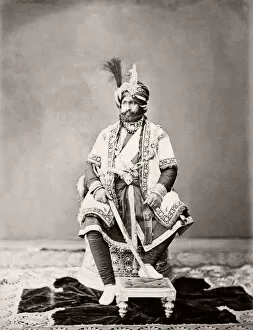
India - the Maharajah of Nabha 1860s19th century vintage photograph India - the Maharajah of Nabha Shepherd and Robertson, 1860s
India - the Maharajah of Kashmir 1860s19th century vintage photograph India - the Maharajah of Kashmir Shepherd and Robertson, 1860s
India - the maharajah of Gwalior 1860s19th century vintage photograph India - the maharajah of Gwalior Shepherd and Robertson, 1860s
India - Raja of Mahmudabad 1860s19th century vintage photograph India - Raja of Mahmudabad Shepherd and Robertson, 1860s
India - the Raja of Farikdot. 1860s19th century vintage photograph India - the Raja of Farikdot. Shepherd and Robertson, 1860s
India - Maharajah of Patiala 1860s19th century vintage photograph India - Maharajah of Patiala Shepherd and Robertson, 1860s
India - Maharajah of Bhoondee Bhundi 1860s19th century vintage photograph India - Maharajah of Bhoondee Bhundi Shepherd and Robertson, 1860s
India - Maharajah of Bhownuggur Bhavnagar 1860s19th century vintage photograph India - Maharajah of Bhownuggur Bhavnagar Shepherd and Robertson, 1860s
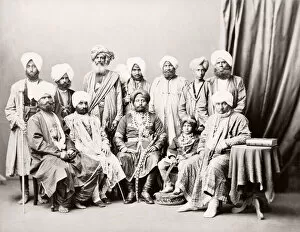
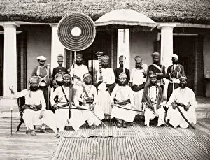
India the Maharajah of Rana of Thellawar and suite 1860s19th century vintage photograph India - the Maharajah of Rana of Thellawar and suite - Shepherd and Robertson, 1860s
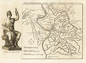
Map of Rome - ancient and modern topographyMap of Rome showing ancient and modern topography. Allegorical figure of Rome. Urbis Topographia ejusque Ambitus Antiquus et Hodiernus. From a map by Francesco Gandini
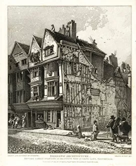
Interregnum timber and plaster houses on LongOld timber and plaster houses from the Interregnum (1650s) on the north side of Long Lane, Smithfield, 1810. Inhabited by soft wood turners
Porch of an old Interregnum house in HanoverSouth east view of the porch of an old Interregnum house known as General Monks house in Hanover Court, near Grub Street, 1809. Built circa 1650
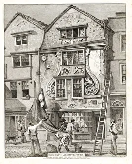
Stuart Houses in the Foliated StyleStuart Houses from the reign of King Charles I in the Foliated Style on the west side of Little Moorfields, 1810. Oak timber house with plaster foliage
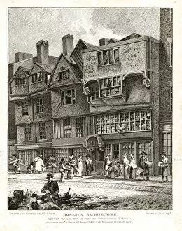
Foliage Style houses on London Wall street, 1808Stuart Houses from the reign of King Charles I in the Foliated Style on the south side of London Wall street, 1808. Oak timber house with plaster foliage
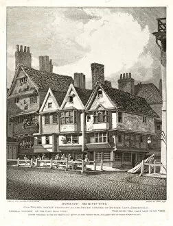
Old Stuart houses at the south corner of HosierOld Stuart houses from the reign of King James I at the south corner of Hosier Lane, Smithfield, 1795. External specimen of the Plain Gable Style. Demolished 1809
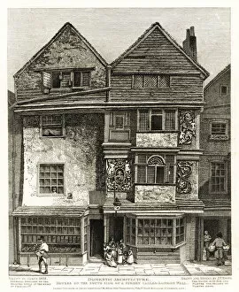
Houses on the south side of Leadenhall Street, 1796. Copperplate engraving drawn and etched by John Thomas Smith from his Topography of London, 1814
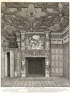
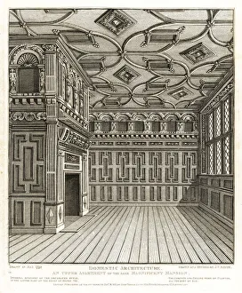
Room on the first floor of Sir Paul Pindar sRoom on the first floor of Sir Paul Pindars house, Bishopsgate Street, 1810. Wood panel walls, stone chimney piece and plaster ceiling and cornices
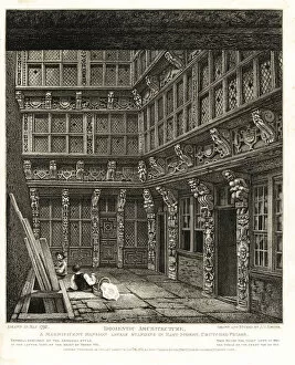
Upper room in a Tudor mansion on Hart StreetUpper apartment in a magnificent Tudor mansion standing on Hart Street, Crutched Friars, 1792. Internal specimen of the Decorated Style with oak panels and plaster ceiling and cornices, 16th century
A magnificent Tudor mansion standing on HartA magnificent Tudor mansion lately standing on Hart Street, Crutched Friars, 1792. External specimen of the Armorial Style with carved oak decoration, 16th century, reign of Henry VIII
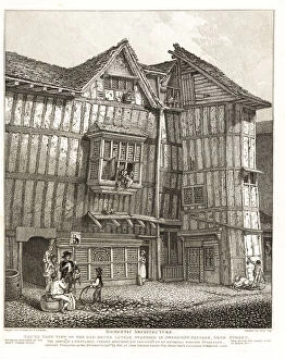
South-east view of a Tudor house in Sweedon sSouth-east view of an old 15th-century Tudor house in Sweedons Passage, Grub Street, 1791. Formerly inhabited by Sir Richard Whittington and Sir Thomas Gresham
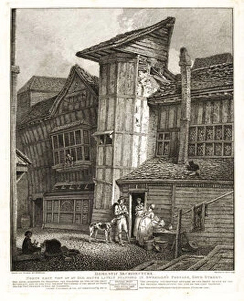
North-east view of a Tudor house in Sweedon sNorth-east view of an old 15th-century Tudor house in Sweedons Passage, Grub Street, 1791. Formerly inhabited by Sir Richard Whittington and Sir Thomas Gresham. Rebuilt 1805
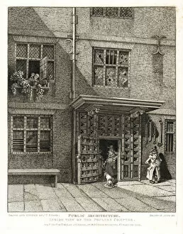
Inside view of the Poultry Compter, 1811, a London prison in Cheapside operated from medieval times to 1815. This particular building was built soon after the great Fire of London, 1666
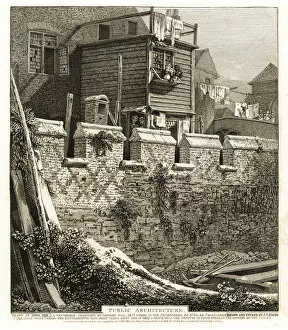
Fragment of London Wall with battlements, 1793Fragment of London Wall with battlements built in 1477 during the reign of King Edward IV as it stood in the churchyard of St. Giles Cripplegate, 1793
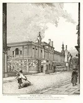
Southwest view of Bethlem or Bedlam Hospital and London Wall, 1814. In the 18th century, visitors paid a penny at the Penny Gate to view the inmates
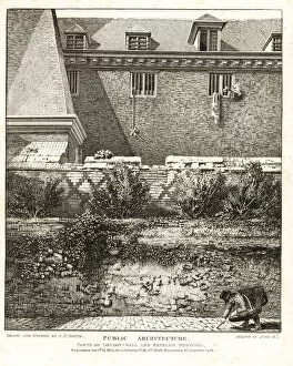
Parts of the London Wall and Bethlem or Bedlam Hospital, built in 1675. Copperplate engraving drawn and etched by John Thomas Smith from his Topography of London, 1814
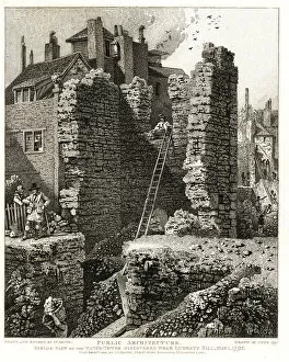
Inside view of the Watch Tower discovered near Ludgate Hill, May 1, 1792. Barbican or part of the old City wall of 1276. Copperplate engraving drawn
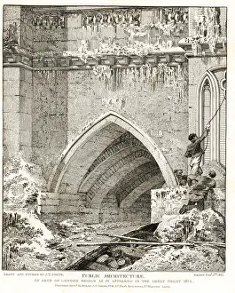
Arch of London Bridge as it appeared in the Great Frost of 1814. Two watermen whose boat has crashed into a groin are pulled to safety by rope
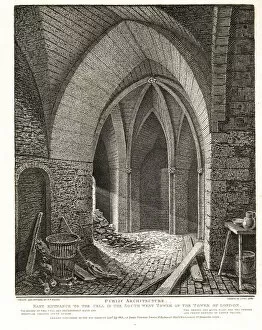
East entrance to the cell in the Southwest Tower of the Tower of London, 1803. Early Pointed Style. Copperplate engraving drawn and etched by John Thomas Smith from his Topography of London, 1811
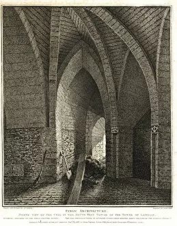
North view of the cell in the Southwest Tower of the Tower of London, 1803. Early Pointed Style. Copperplate engraving drawn and etched by John Thomas Smith from his Topography of London, 1811
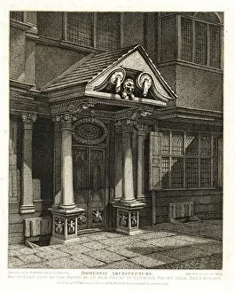
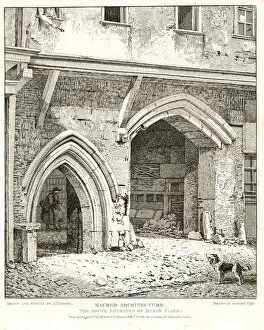
South entrance of Dukes Palace, 1790. Copperplate engraving drawn and etched by John Thomas Smith from his Topography of London, 1814
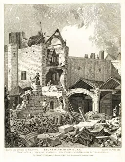
Ruins of the Chapel and Granary of Leadenhall Chapel, 1813North-east view of the ruins of the Chapel and Granary of Leadenhall Chapel (Holy Trinity Chapel, Leadenhall Street). Copperplate engraving drawn
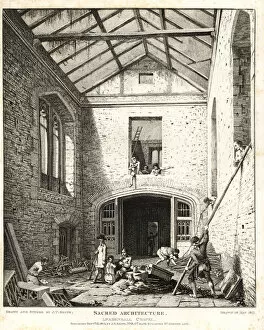
Interior of the ruins of Leadenhall Chapel, 1812Interior of the ruins of Leadenhall Chapel (Holy Trinity Chapel, Leadenhall Street). Copperplate engraving drawn and etched by John Thomas Smith from his Topography of London, 1814
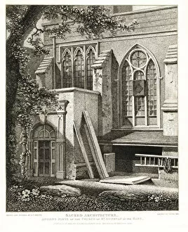
Ancient parts of the Church of St. Dunstan in the East. Copperplate engraving drawn and etched by John Thomas Smith from his Topography of London, 1813
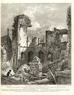
Walls of the Convent of St. Clare or Minoresses, 1797Parts of the north and east walls of the Convent of St. Clare or Minoresses, founded 1293. After the fire of March 23, 1797. Walls of Caen stone and chalk, timber oak and chestnut
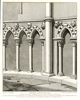
Part of the Vestibule of the Temple Church, built 1185. Decorated Norman style architecture with pointed arches and heads
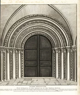
West entrance to the vestibule of the Temple Church, built 1185. Decorated Norman style architecture. Copperplate engraving drawn and etched by John Thomas Smith from his Topography of London, 1811
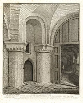
Back of the original altar of St. BartholomewNorth-east view of the back of the original altar of St. Bartholomew the Greater, built 1102. Door to charnel house at right
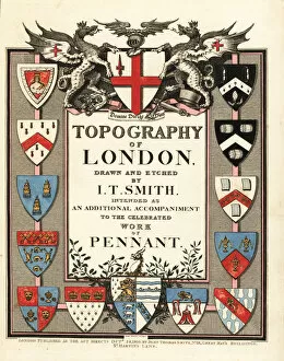
Title page with calligraphy and heraldic shields. Handcoloured copperplate engraving Richard Sawyer from John Thomas Smiths Topography of London, 1810
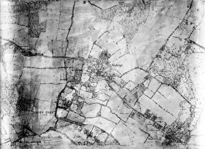
Map of Sidcup and environs - Black and white (negative) lantern slide. Map of Sidcup and environs.. Part of Box 399. Boswell Collection. Date: circa 1900
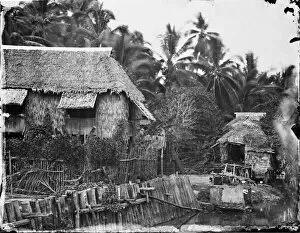
Native houses, Cebu, Visayas, PhilippinesA photograph taken during the voyage of H.M.S. Challenger (1872-1876) funded by the British Government for scientific purposes