mail_outline sales@mediastorehouse.com
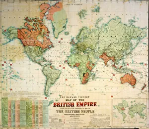
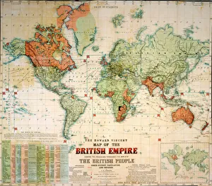
Map of the British EmpireThe Howard Vincent map of the British Empire, 1897 Date: 1897
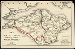
Map of Isle of WightA Map of the Isle of Wight, showing the internal railway system and the new & short route between the island and the Hampshire coast
Nelson outlining his battle plans for Trafalgar, 1805This picture illustrates the famous incident when Nelson, visiting Lord Sidmouth five weeks before Trafalgar, dipped a finger in the port and sketched his plan for the expected battle
Elizabethan London, stretching from St James Park in the west to Whitechapel and the Tower in the east. Theatres and other places of ill-repute are located on the south bank
Bouncing BombPlans for Operation Chastise drawn by Sir Barnes Neville Wallis for the bouncing bomb used in the raid known as the Dambusters in World War II Date: c. 1943
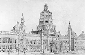
Victoria and Albert Museum, London - Aston Webb Front - the final modified design - opened in 1909. Date: 1903
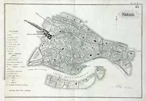
Map of VeniceMap of the city of Venice, Italy Date: 19th century
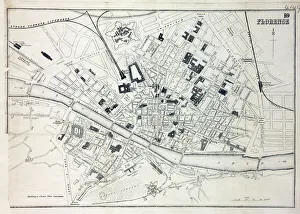
Map of FlorenceMap of the city of Florence, Italy and the River Arno Date: 19th century
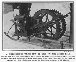
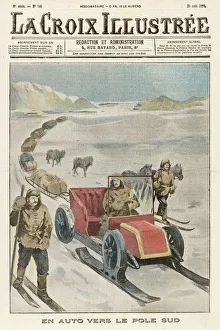
A motor sledge which may be used at the South PoleA suggestion for the type of motor sledge to be taken by Captain Scott, who in 1909 had announced his intention to set out on a new expedition to the South Pole
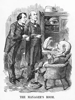
Gladstone / Disraeli 1874The Managers Room Mr Punch as theatre manager asks his dramatists Gladstone and Disraeli what their plans are for the season. Date: 3 January 1874
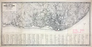
Map of LisbonMap of the city of Lisbon, Portugal 1871 Date: 1871
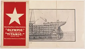
White Star Line, Olympic and TitanicA White Star Line booklet containing plans of the Olympic and Titanic triple-screw steamers. Part of a cross-section plan can be seen, revealing the various levels towards the prow of the ship
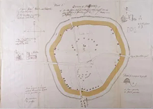
Aubreys Plan of AveburyJohn Aubreys plan of Avebury. Aubrey was an English antiquary, who suplimented his writings on sites with detailed plans and sketches
Shackletons Sled-CarIn his attempt on the South Pole, Shackleton plans to use this specially designed automobile, rather then dogs, to haul his supplies
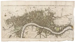
London Map 1756London still surrounded by fields, with Tyburn (note the gallows) and Buckingham House on the outskirts. Trafalgar Square doesn t exist, and Mayfair is still undeveloped
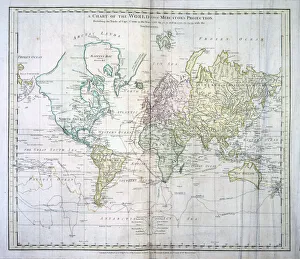
Map of the WorldThe World, showing Captain James Cooks voyages from 1768 - 1775, based on Mercators Projection, published by William Faden 1778 Date: 1778
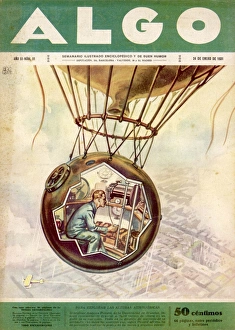
Piccard 1931 Ascent - 4Drawing showing the balloon in which Swiss scientist Auguste Piccard plans to fly higher than anyone has ever flown before - a project which will be realised in May
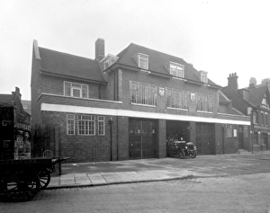
LCC-LFB Dockhead fire station, BermondseyDockhead fire station, Bermondsey, SE London, built in 1928. This fire station was the location for the early seasons of the ITV series Londons Burning
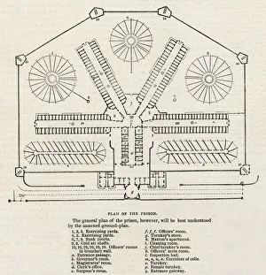
Plan Pentonville PrisonA plan of the floor layout of Pentonville, a model prison built in London in 1843, with corridors of cells radiating out from a central point & exercise yards
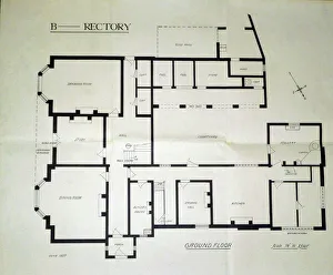
Architectural plans of Borley Rectory. By Sidney Glanville. Scale of plans is 1 foot to 1/4. Ground floor Date: 1937
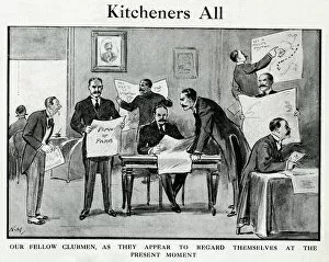
Cartoon, Kitcheners All, WW1Cartoon, Kitcheners All, First World War. A scene in a London club, where nearly all of the members look just like Lord Kitchener, each one with his own ideas of how the war should be run. Date: 1914
North American FJ-1 Fury plans
Maps Wrens LondonChristopher Wren seizes the opportunity of the Great Fire to draw up plans for a brave new London - which alas will be only partially realised. Date: 1666
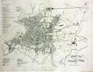
Map of Rome
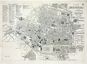
Map of BrusselsMap of the city of Brussels, Belgium Date: 19th century
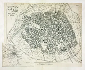
Map of ParisBradshaws Plan of Paris, France and map of the environs Date: 19th century
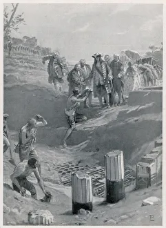
Pompeii Excavation, 1751Carlo III di Borbone visits the first excavations at Pompeii
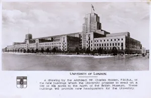
University of London - Plans of the new buildings - HoldenUniversity of London - Drawing based on the plans for the new buildings by Architect Charles Holden (1875-1960). Date: circa 1930
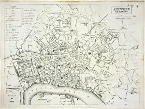
Map of AntwerpMap of the city of Antwerp, Belgium Date: 19th century
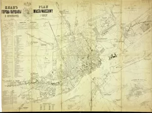
Map of WarsawMap of the city of Warsaw, Poland from 1862 Date: 1862
Wandsworth County Court, Sections, 1858 Date: 1858
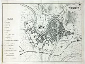
Map of VeronaMap of the city of Verona, Italy Date: 19th century
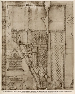
Plan of John Evelyns gardenA plan of John Evelyns garden at Sayes Court, Deptford, shown looking south, which he occupied from 1652 to 1694
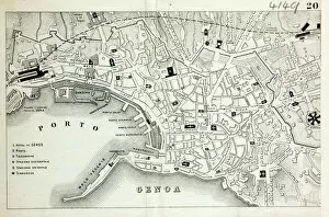
Map of GenoaMap of the city of Genoa, Italy Date: 19th century
Ludendorff and MapsGENERAL EFW VON LUDENDORFF Der Feldherr Ludendorff studies plans of the battlefield
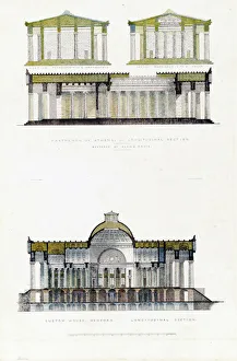
Parthenon of Athens and Custom House, New YorkParthenon of Athens, - Longitudinal Section.; B. Custom House, New York. Longitudinal Section. Date: ca. 1835
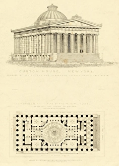
Custom House, New York. Date: ca. 1835
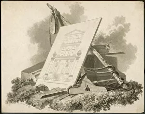
Tools of an ArchitectA plan for a neo-classical building is rested against the tools of the surveyors architects and builders who will construct this edifice
Invasion Plan / TunnelWhen Napoleon contemplates an attack on England, a tunnel beneath the Channel is one of his options, though it is unlikely he seriously considers it
Laclos / Liaisons / ValmontLe Vicomte de Valmont uses his mistress, Opera as a writing desk whilst writing to the virtuous Mme. Tourvel, whom he plans to seduce
Jack Climbing StalkJack, having grown the beanstalk from the magic seed given him by a fairy, uses it to enable him to reach the home of the Giant, whom he plans to kill
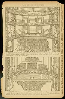
Seating / Lycuem & StrandPlans showing the layout of seating available for booking at the Lyceum and Strand Theatres with prices ranging from Boxes to the Gallery via stalls, circles & the pit
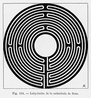
Maze at SensCircular maze in the cathedral at Sens, France
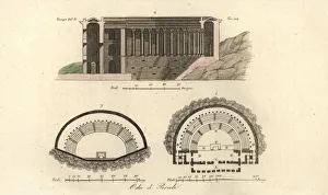
Plans and section of the Odeon of Pericles, Athens, GreecePlans and section of the Odeon of Athens or Odeon of Pericles in Athens, Greece. Odeo di Pericle. Handcoloured copperplate engraving after an illustration by Luigi Antonio Bossi from Giulio Ferrarios
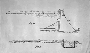
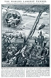
Tunnel connecting Liverpool with Birkenhead 1926Diagram showing where the tunnel connecting Liverpool to Birkenhead would be, under the River Mersey. Spanning 44ft wide with two desks for vehicles only
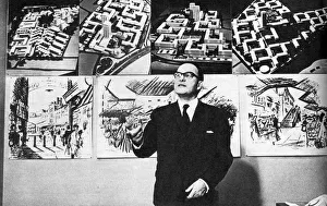
Konrad SmigielskiLeicester plans for her future, 1964. The City of Leicesters planning officer in the 1960s, Konrad Smigielski. Date: 1964
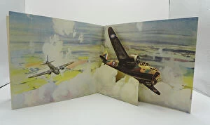
WW2 - Royal Air Force 3D PictureAn illustrated three dimensional page of a WW2 children's book, showing a pair of British Royal Air Force plans in flight. Date: circa 1940s