mail_outline sales@mediastorehouse.com
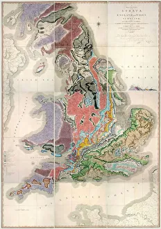
William Smith Geological Map
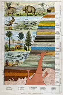
Geological Strata 19CA schematic representation of geology and palaeontology
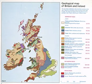
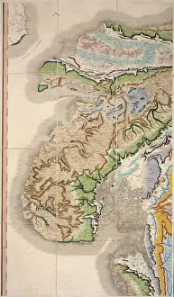
Geological map of Britain and IrelandFig 9 from Britain Before Man (1978), a Geological Museum publication
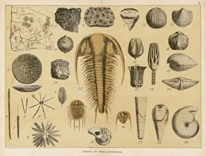
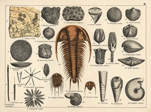
Fossils from the palaeozoic eraLife forms of the palaeozoic era (for identification of individual items, refer to the book page 13-14)
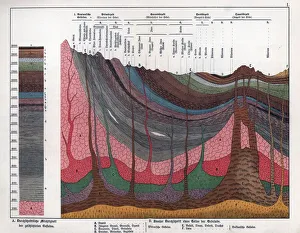
Geological crosssection through the Earths crust.. Chromolithograph from Dr. Fr. Rolles Geology and Paleontology section in Gotthilf Heinrich von Schuberts Natural History, Schreiber, Munich, 1886
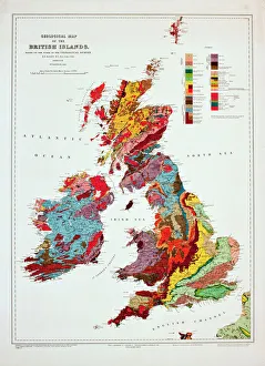
Geological map of the British Islands. 1941
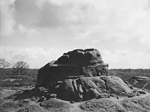
The Devils Chimney, a distintive natural rock formation on Leckhampton Hill, overlooking the road between Cheltenham and Birdlip, Gloucestershire, England. Date: late 1930s
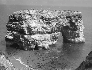
Marsden RockMarden Rock, near South Shields, County Durham, England. Date: BC
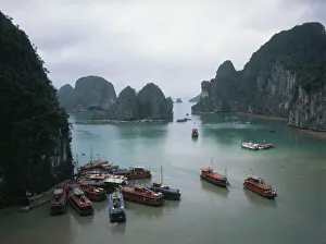
Halong Bay, Quang Nin, VietnamView of Halong (or Ha Long) Bay, near Ha Long City (also known as Hong Gai), capital of Quang Nin Province, Vietnam. Ha Long Bay (meaning Descending Dragon Bay)
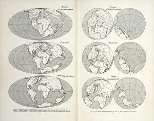
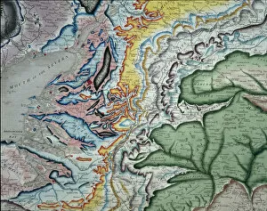
Continental drift mapsReconstruction of the map of the world for three periods according to the Displacement Theory. Figs 1-2 from The Origin of Continents and Oceans (1924) by Alfred Wegener
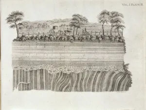
Geological unconformity on the river Jed. Plate 3 from Theory of the Earth (1795) Vol. 1, by James Hutton
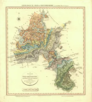
Geological Map of OxfordshireDelineation of Strata of Oxfordshire by William Smith
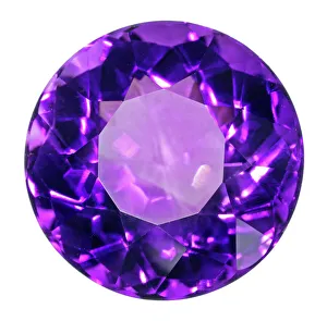
Birthstone Series: Amythest QuartzAn Amythest quartz specimen. Amythest is a form of quartz that is usually purple in colour, it is the birthstone for the month of March. Natural History Museum specimen number 84817
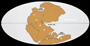
Continental DriftThe world 200 million years ago in Upper Triassic times, showing the single continent of Pangaea and the universal ocean, Panthalassa
William Smiths geological mapPart of William Smiths geological map of Great Britain, published in 1815
Coal forest dioramaA diorama of a Carboniferous coal forest (354 to 290 million years ago) previously on display at the former Geological Museum which is now part of the Natural History Museum, London
Perranporth Rock ArchThe Rock Arch, an unusual formation, on the beach at Perranporth, Cornwall, England. Date: 1960s
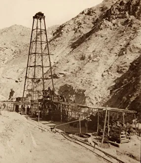
Oil Well at Chillingar, Iran. One of Irans largest oil fields, Chilingar was named after George V. Chilingar, one of the best-known petroleum geologists in the world
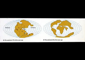
Continental drift diagramsA) The continents 175 million years ago. B) The continents 50 million years ago. Figs 65 & 67 from The Age of the Earth. See also < a href= http://piclib.nhm.ac.uk/results.asp
Thatcher RockA picturesque glimpse of the weel-know Thatcher Rock at Torquay, Devon, England. Date: 1950s
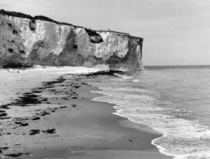
Joss Bay CliffsThe white chalk cliffs and foreshore at Joss Bay, Isle of Thanet, Kent, England. Date: 1950s
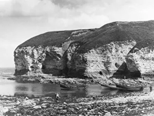
Flamborough HeadThe North Landing, Flamborough Head, Yorkshire, England; the chalk cliff is riddled with former smuggling caves. Date: 1950s
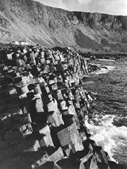
The Giants Causeway, on the coast of County Antrim, Northern Ireland. It is a promontory of collumnar basalt polygonal pillars, mainly pentagonal and hexagonal. Date: 1930s
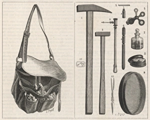
Geologists EquipmentA geologists equipment includes hammers, a sieve, tweezers and a strong satchel
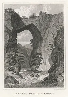
Natural Bridge VirginiaA river flows beneath a massive natural bridge in Virginia, USA
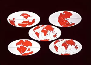
Continental Drift5 diagrams illustrating the positions of the continents 380 mya, 200 mya, 135 mya, 50 mya and the present
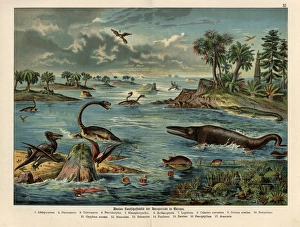
Jurassic reptiles, dinosaurs, fish and birds.. Chromolithograph from Dr. Fr. Rolles Geology and Paleontology section in Gotthilf Heinrich von Schuberts Natural History, Schreiber, Munich, 1886
Plant landscape of the Permian.. Chromolithograph from Dr. Fr. Rolles Geology and Paleontology section in Gotthilf Heinrich von Schuberts Natural History, Schreiber, Munich, 1886
Trilobite, sponge and zoophyte fossils.. Chromolithograph from Dr. Fr. Rolles Geology and Paleontology section in Gotthilf Heinrich von Schuberts Natural History, Schreiber, Munich, 1886
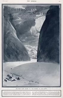
The Highway to the South - Scott expeditionThe magnificent entrance to the Beardmore Glacier showing the snow slope leading up to the two massive granite pillars through which Captain Scott passed with his men
William Smiths Geological MapFig. 6 from Delineation of Strata of England and Wales (1815) by William Smith
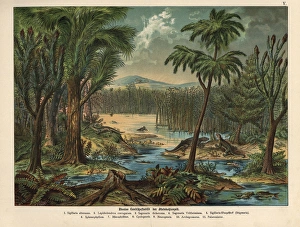
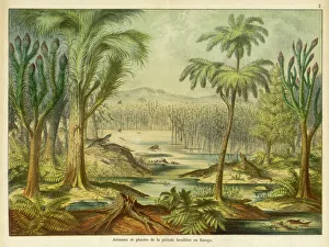
Animals and plants of the Carboniferous eraEuropean landscape, with animals, during the Carboniferous Era
THORs STONEThors Stone, a natural rock formation, where Vikings are reputed to have offered human sacrifices to Thor, the god of thunder; Thurstaston, Merseyside, England. Date: BC
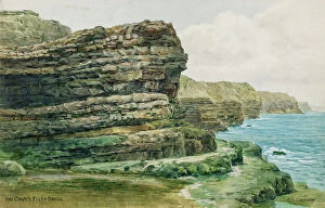
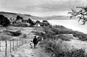
Caves at Filey Brigg, North Yorkshire - Painted by landscape artist Alfred Robert Quinton for the Sevenoaks based publishing and printing company J. Salmon, and reproduced as a local view postcard
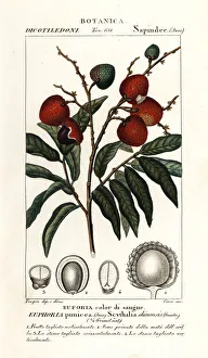
Lychee fruit, Litchi chinensis. Euphoria punicea, Scythalia chinensis, Euforia color di sangue. Handcoloured copperplate stipple engraving from Antoine Laurent de Jussieus Dizionario delle Scienze
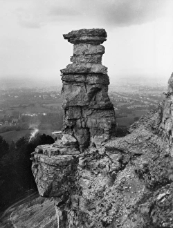
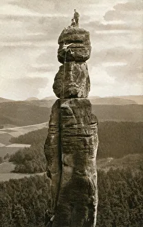
The Barbarine - first climbed 1905 - GermanyThe Barbarine - the best-known, free-standing rock formation in the German part of the Elbe Sandstone Mountains. The pinnacle is the symbol of Saxon Switzerland
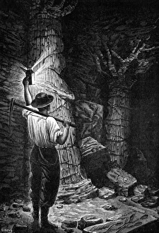
Fossil trees in coal mineFossilised trees and plants found in a coal mine. Date: C.1870
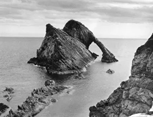
Bow Fiddle Rock, a well-known natural rock formation, at Scaurnose, on the Banffshire coast, between Cullen and Portknockie, Scotland. Date: 1960s
The Jurassic Coast of Lyme Regis, Dorset
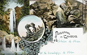
Sliven, Bulgaria - The Sinite Kamani rocksSliven, Bulgaris. The famous rocky massif Sinite Kamani ( The Blue Rocks ) and the associated national park, the fresh air and the mineral springs offer diverse opportunities for leisure and tourism
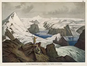
Franz Josef Fjord and Peterman Mountain, GreenlandView of the Franz Josef Fjord (named after the Emperor who helped to fund an expedition there) and the Peterman Mountain, with glacier, in north eastern Greenland
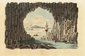
Basalt columns in Fingals Cave, Staffa, Inner Hebrides, Scotland. Handcoloured steel engraving by Pfitzer from Felix-Edouard Guerin-Menevilles Dictionnaire Pittoresque d Histoire Naturelle
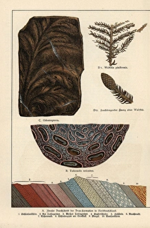
Fern fossils from the Permian.. Chromolithograph from Dr. Fr. Rolles Geology and Paleontology section in Gotthilf Heinrich von Schuberts Natural History, Schreiber, Munich, 1886
Plate 7a from Histoire naturelle? (1789)Plate 7a, Mineralogie [unfinished] from Histoire naturelle: ou, Exposition des morceaux, les mieux choisis pour servir? (1789) by by Swebach Desfontaines
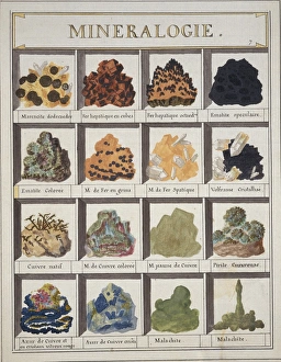
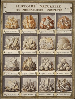
Plate 1 from Histoire naturelle? (1789)Plate 1 Histoire Naturelle ou Mineralogie Complete, from Histoire naturelle: ou, Exposition des morceaux, les mieux choisis pour servir? (1789) by by Swebach Desfontaines
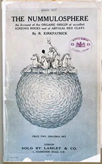
The Nummulosphere Part I. Front CoverAn account of the organic origin of so-called igneous rocks and of abyssal red clays by Kirkpatrick, Randolph (1863-1950), London. 1913
Watchet Cliff StrataThe curious cliff strata at Watchet, Somerset, England
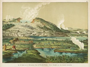
Te Tarata hot springs, Rotomahana, New ZealandView of the Te Tarata hot springs by Lake Rotomahana, North Island, New Zealand -- thermal springs with encrusted terraces