mail_outline sales@mediastorehouse.com
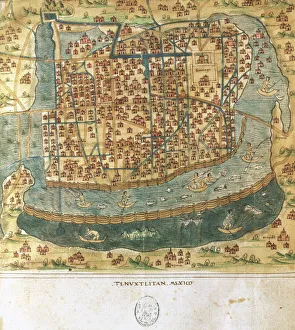
Map of Tenochtitlan. Mexico, 1560. By Alonso de Santa CruzMap of Tenochtitlan. Mexico, 1560. General islario of all the islands in the world. Work of the chronicler and cosmographer Alonso de Santa Cruz (1505-1567). National Library. Madrid. Spain
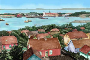
Norway. Horten. 19th century. View of the city with the port and arsenal of the state with the Spanish frigate Blanca entering in the drydock
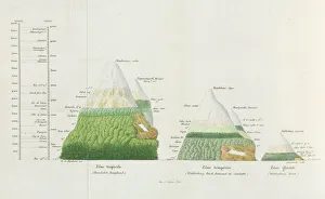
Distributions of plants at various altitudesColoured engraving of Alexander Humboldt illustration. Tableaux de la Nature, 1865. Date: 1865
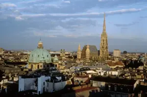
Austria. Vienna. ViennaAUSTRIA. VIENNA. Vienna
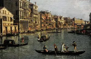
Grand Canal Looking South-East from the Campo Santa Sophia tCanaletto (1697-1768). Italian painter. Grand Canal Looking South-East from the Campo Santa Sophia to the Rialto Bridge, c. 1756. Detail. Gemaldegalerie. Berlin. Germany
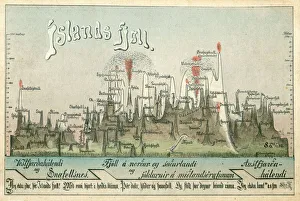
The Geography of IcelandThe peaks of mountains and volcanoes in Iceland depicted in this fascinating postcard. Featured is the Eyjafjallajoekull volcano (just to the left of the erupting Hekla Volcano - centre left)
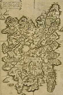
Map of Corsica. Italian engraving. 16th century
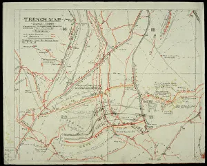
WW1 - Trench map from a soldiers war diary showing the Somme Battlefield with information gleaned from captured German Prisoners
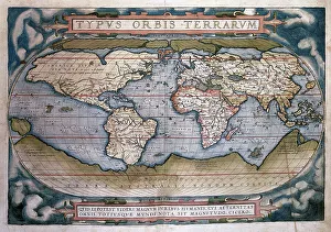
Theatrum Orbis Terrarum (Theatre of the World) by Abraham OrTheatrum Orbis Terrarum (Theatre of the World). Is considered to be the first true modern atlas. Written by Abraham Ortelius and originally printed on May 20, 1570, in Antwerp. World Map
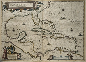
Atlas Novus, 17th c Map of the CaribbeanBLAEU, Jan (1596-1673). Atlas Novus or Atlas Maior. 1635 - 1665. Insulae Americanae in Oceano Septentrionali cum Terris Adiacentibus. Map of the Caribbean islands printed in Amsterdam circa 1645
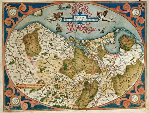
Map of Germany and current Netherlands. Theatrum Orbis Terrarum by Abraham Ortelius (1527-1598). First Edition. Antwerp, 1574. Library of Catalonia. Barcelona. Spain
Nyanga Forest and pool - Zimbabwe
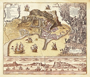
Map of Gibraltar (XVIIIIth c. ). EtchingMap of Gibraltar (XVIIIIth c.). Etching
World map by Claudius Ptolemy (90-168). Engraving, 16th centClaudius Ptolemy (90-168) Greco-Egyptian geographer. World map. Engraving, 16th century
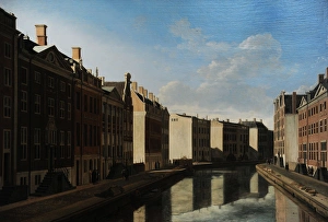
The Golden Bend in the Herengracht, Amsterdam, Seen from theGerrit Adriaensz Berckheyde (1638-1698). Dutch painter. The Golden Bend in the Herengracht, Amsterdam, Seen from the East, 1671-1672. Rijksmuseum. Amsterdam. Holland
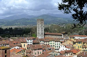
Italy. Lucca. Panorama of the old town with the Basilica of San Frediano, 12th century, from the Guinigi Tower
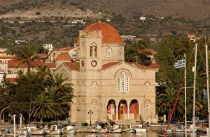
Church of Agios Nikolaos. Aegina. GreeceGreece. Aegina. Church of Agios Nikolaos. Exterior. Aegina Island
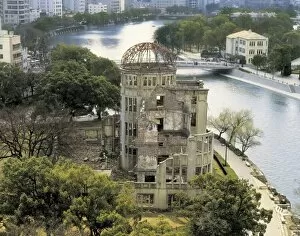
JAPAN. HONSHU. HIROSHIMA. Hiroshima. Atomic Bomb
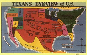
A Texans eye view of the USA, with a certain state having slightly more georgraphical significance than the physical reality....!! Date: circa 1930s
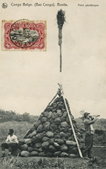
Trigonometry PointA Trigonometry Point at Buvita in the Belgium Congo, topped off with a broom!
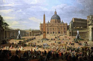
The output of the Duke of Choiseul (1719-1785) of St. PeterGiovanni Paolo Panini (1691-1765). Italian painter. The output of the Duke of Choiseul (1719-1785) of St. Peters Square in Rome, 1754. Gemaldegalerie. Berlin. Germany
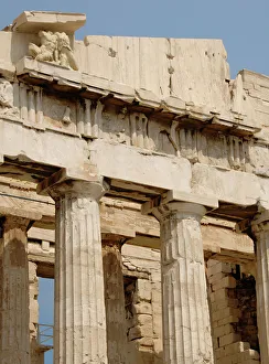
Parthenon. Athens. GreeceGreece. Athens. Parthenon. 447-438 BC. in Doric style under leadership of Pericles. The building was designed by the architects Ictinos and Callicrates. Acropolis
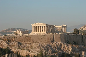
Athens. Panoramic view of the Acropolis. Parthenon. Attica. Central Greece
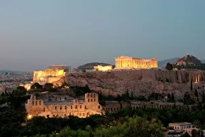
Athens. Panoramic view of the Acropolis at night. Attica. Central Greece
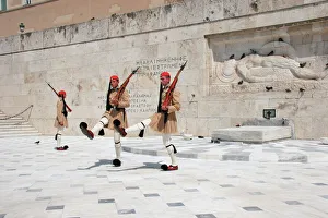
Chaging of the guard. Athens. GreeceChanging of the guar. The Tomb of the Unknown Soldier. Athens. Attica. Greece
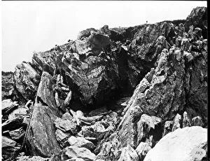
Glacial rock, Halifax 1873A photograph taken during the voyage of H.M.S. Challenger (1872-1876), funded by the British Government for scientific purposes
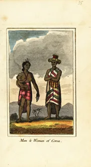
Man, woman and baby of Corea, Korea, 1818. Handcoloured copperplate engraving from Mary Anne Vennings A Geographical Present being Descriptions of the Principal Countries of the World, Darton
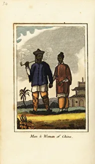
Man and woman of China, 1818. Man with tobacco pipe, holding hands with a woman. Handcoloured copperplate engraving from Mary Anne Vennings A Geographical Present being Descriptions of the Principal
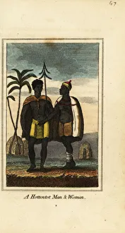
Khoikhoi man and woman, South Africa, 1818. They wear animal skins and woven skirts and stand in front of huts covered in animal hides
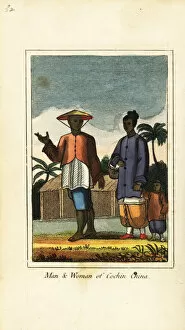
Man and woman of Cochin China (Vietnam) 1818. Handcoloured copperplate engraving from Mary Anne Vennings A Geographical Present being Descriptions of the Principal Countries of the World, Darton
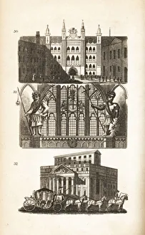
London Guildhall, Gog and Magog and the Mansion House. View of the Guildhall in Moorgate 30, statues of the mythological giant Gogmagog and Corineus 31
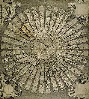
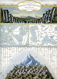
Waterfalls, Islands, Lakes, Rivers and Mountains ?Waterfalls, Islands, Lakes, Rivers and Mountains of Eastern Hemisphere
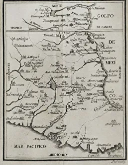
Map of the territory of New Spain. Historia de la Conquista de Mexico, poblacion, y progresos de la America septentrional, conocida por el nombre de Nueva Espana (History of the Conquest of Mexico)
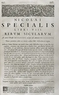
Rerum sicularum libri VIII, by Nicolai Specialis (Nicola Speciale, 14th century historian of Sicilian origin). In his work he described the deeds of the kings of the Crown of Aragon
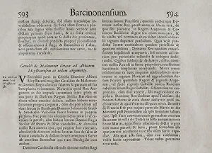
Barcinonensium. Marca Hispanica sive limes hispanicus. Book written in Latin by Pierre de Marca (1594-1662). In 1656 he was commissioned to formalise the border treaty between the kingdoms of France
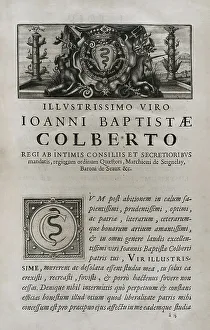
Marca Hispanica sive limes hispanicusIllustrisimo Viro Ioanni Baptistae Colberto, marquis de Seignelay (1651-1690). Marca Hispanica sive limes hispanicus. Book written in Latin by Pierre de Marca (1594-1662)
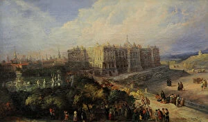
View of the Royal Palace of Madrid by Genaro Perez VillaamilGenaro Perez Villaamil (1807-1854). Spanish painter. View of the Royal Palace of Madrid, 1854. History Museum. Madrid. Spain
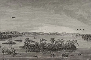
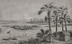
Africa. Floating islands in the Upper CongoHistory of Africa. 19th century. Floating islands on the Upper Congo River. Engraving. El Congo y la Creacion del Estado Independiente de este nombre
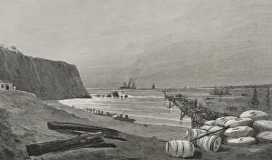
History of Africa. Ambriz CoastHistory of Africa. 19th century. Ambriz Coast. Engraving. El Congo y la Creacion del Estado Independiente de este nombre. Historia de los Trabajos y Exploraciones Verificados
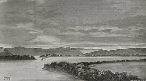
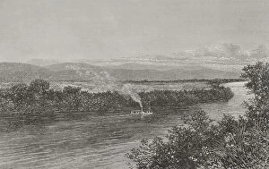
Africa. Panorama of Lake Stanley from Mount LeopoldHistory of Africa. 19th century. Panorama of Stanley Pool from Mount Leopold. Engraving by W. Meyer. El Congo y la Creacion del Estado Independiente de este nombre
Panorama of the Kassai landscapeHistory of Africa. 19th century. Panoramic view of the Kasai River landscape. Engraving. El Congo y la Creacion del Estado Independiente de este nombre
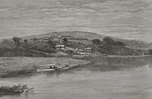
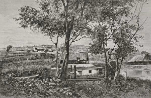
History of Africa. The Congo. Leopoldville stationHistory of Africa. 19th century. The Congo. Leopoldville station. Panoramic view of the trading post and port from Ngaliema Bay in 1884. It was the first main Colonial Post near Stanley Pool
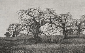
Africa. The Congo. Baobabs at the end of the dry seasonHistory of Africa. 19th century. The Congo. Baobabs at the end of the dry season. Engraving. El Congo y la Creacion del Estado Independiente de este nombre
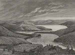
Africa. The Congo. Access to Lake Leopold IIHistory of Africa. 19th century. Access to Lake Leopold II. Engraving. El Congo y la Creacion del Estado Independiente de este nombre
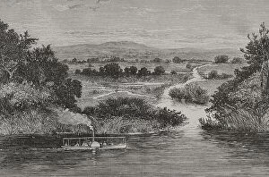
The Congo. Boat upstreaming the Fimi RiverHistory of Africa. 19th century. Boat upstreaming the Fimi River towards Lake Leopold II. Engraving. El Congo y la Creacion del Estado Independiente de este nombre
Africa. The Congo. View of Leopoldville, April, 1882History of Africa. 19th century. The Congo. View of Leopoldville, April, 1882. Engraving. El Congo y la Creacion del Estado Independiente de este nombre
Africa. The Congo. Panorama of Leopoldville and KintamoHistory of Africa. 19th century. The Congo. Panorama of Leopoldville and Kintamo. Engraving. El Congo y la Creacion del Estado Independiente de este nombre
Africa. The Congo. Congo River near Kalubu. Panoramic viewHistory of Africa. 19th century. The Congo. Panorama of the landscape and the Congo River near Kalubu. Engraving. El Congo y la Creacion del Estado Independiente de este nombre