mail_outline sales@mediastorehouse.com
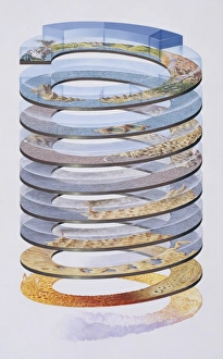
Geological timescaleA diagram showing geological time on earth as expressed in a spiral starting with earth in a molten state and progressing through deserts to the rise of mountain ranges and volcanoes
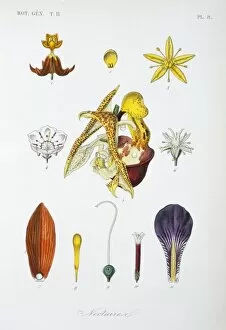
Nectaries from various flowersPlate 8 from Le Regne Vegetal. Vol 4 Botanique Atlas 2 (1870). Held in the Botany Library at the Natural History Museum, London
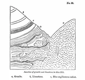
Junction of granite and limestoneFig 88 from Principles of Geology, being an attempt to explain the former changes of the Earths surface. Vol. 3 1832-33 by Charles Lyell (1797-1875)
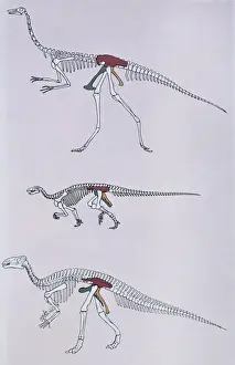
Dinosaur skeletons comparing hip pelvic structureThe pelvis consists of three bones on each side. Top, a Saurischian dinosaur. Middle, an early Ornithischian dinosaur. Bottom, a Later Ornithischian dinosaur
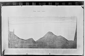
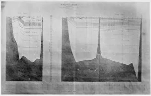
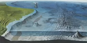
Chart of oceanic section, Tenerife to SombreroA photograph taken during the voyage of H.M.S. Challenger (1872-1876) funded by the British Government for scientific purposes
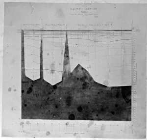
Chart of oceanic section, Bermuda to AzoresA photograph taken during the voyage of H.M.S. Challenger (1872-1876) funded by the British Government for scientific purposes
Chart of oceanic section, to St. Pauls Rocks
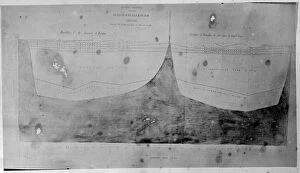
Chart of oceanic section, Tristan D Acunha to Cape of Good HA photograph taken during the voyage of H.M.S. Challenger (1872-1876) funded by the British Government for scientific purposes
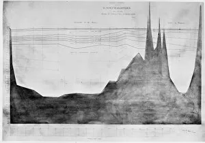
Chart of oceanic section, Halifax, BermudaA photograph taken during the voyage of H.M.S. Challenger (1872-1876) funded by the British Government for scientific purposes
Diagrammatic section of the Earths crustFold-out plate from Geology and Mineralogy Considered with Reference to Natural Theology (1836) by William Buckland
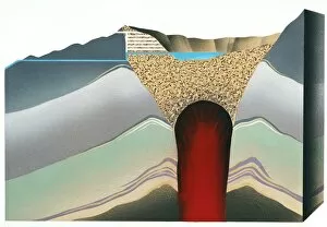
Section through volcano crater lakeIllustration shows a section through volcano crater lake and also the system of tunnels at Kelut, Java, which drain the crater lake
Section through the Earths crustSection showing the two main types of the Earths crust: oceanic and continental
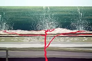
Ocean floorDiagram of the main features of the ocean floor, including an oceanic ridge, island arc and sea mounts
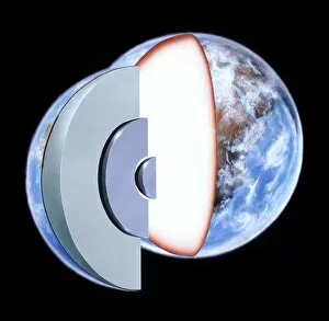
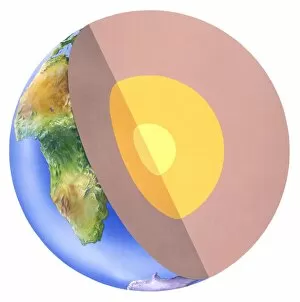
Diagram showing the Earths interiorCrust - continents 35km, oceans 6km. Mantle - peridotite 2900km. Outer core - iron (liquid) 2000km. Inner core - iron (solid) 1370km
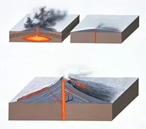
Volcano typesBlock diagram showing: (top left) Glowing cloud eruption, (top right) a shield volcano and (Bottom) a strato-volcano
Submarine volcanic eruptionA submarine volcanic eruption may often produce a Tsunami or trigger earthquakes. One of a series (including image numbers 185 to 190) showing various forms of volcanic eruption
Cornubian granite batholithThe Cornubian granite batholith and its main outcrops in the Cornwall and Devon area, Southwest England. From Britain Before Man 1978, by F W Dunning
Volcanic ActivityBlock diagram showing various types of volcanic activity. One of a series of diagrams (including image numbers 185 to 190) showing volcanic activity
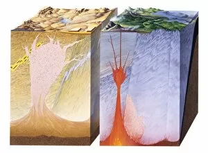
Igneous activityA block diagram depicting various types of igneous activity. Fig 65 from The Story of the Earth (1977), a Geological Museum booklet
Origin of Gem MineralsA diagram showing cross sections through the earths continental crust to a depth of 40kms. Many gemstones form within the crust at different levels and at different temperatures
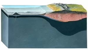
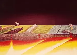
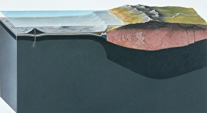
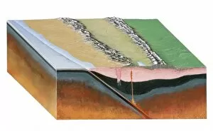
Oceanic and continental crustA cross section of the Earths surface showing the continental crust on the left and oceanic crust on the right. Beneath the surface layer lies the Basaltic layer (in green) and the Mantle (in grey)
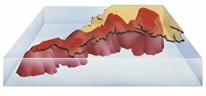
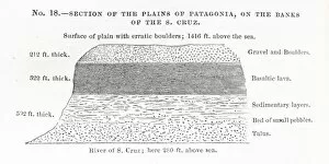
Section of the plains of Patagonia diagramSection of the plains of Patagonia, on the banks of the S.Cruz cross-section diagram (p.114) from Charles Darwins Geological Observations on South America, 1846
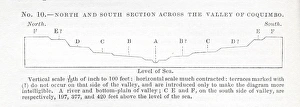
North and South section across the valley of Coquimbo, diagNorth and South section across the valley of Coquimbo diagram (p.240) from Charles Darwins Geological Observations on South America, 1846
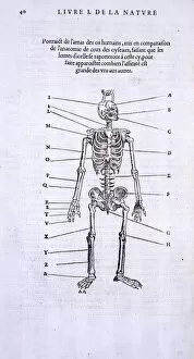
Homo sapiens skeletonAn illustration showing a male human skeleton, page 40 from Histoire de la Nature by P Belon, 1555. In the publication this is ompared with skeleton of a bird on page 41. (See image 6887)
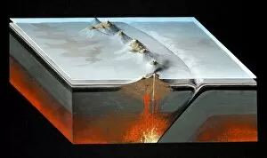
Subduction zoneAn illustration of a subduction zone at work beneath the South American continent. Fig 20 from The Story of the Earth 1977, London
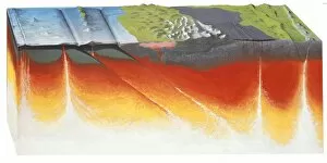
Oceanic subduction zone with island arcThis diagram shows a destructive plate margin, an oceanic subduction zone accompanied by a volcanic island arc
A cross section of the Earth showing the mantle (the thick outer layer), the core (the inner layer) and the inner core (the centre)
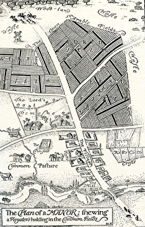
Plan of a manor house and common fields 15th Century
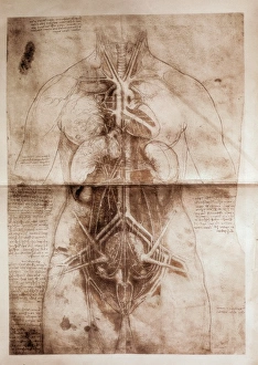
Anatomical studyA study of female anatomy by Leonardo Da Vinci (1452-1519)
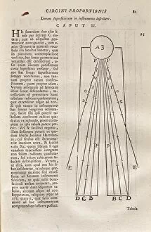
Opere de Galileo GalileiIllustration from chapter 2, volume I, of the " Opere de Galileo Galilei", the works of Italian mathematician, physicist and astronomer, Galileo Galilei (1564-1642)
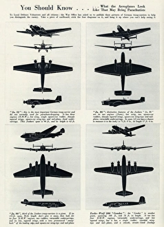
What German troop-carriers look from above 1940You should know... What the German troop-carriers look like in the air. 1940
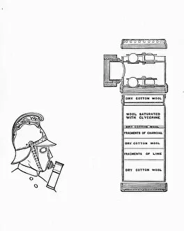
Diagram of a fire brigade respirator
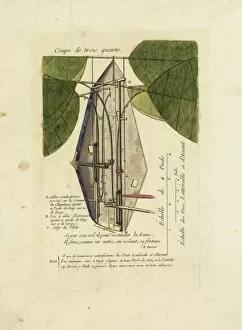
Technical diagram of a flying machine, with measurements and annotations. The small red circle labelled C is the pilots seat. late 18th century
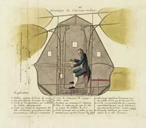
Technical diagram of a flying machine, with pilotTechnical diagram of a flying machine, with measurements and annotations, and a pilot seated at the controls. circa late 18th century
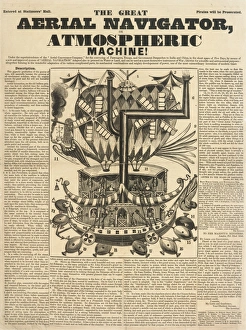
The Great Aerial Navigator, or Atmospheric Machine! An article with a detailed diagram showing an aerial machine claimed to be capable of transportation to India and China in the space of five days
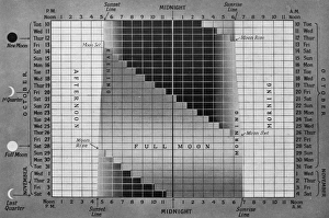
Guide to available moonlight during 1939A diagram prepared for readers of The Sphere in order that they may know, at a glance, how much moonlight they will get on any particular evening of the period
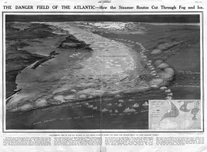
Titanic - Danger Field of the Atlantic with routes through iA diagram or map showing the dangerous area of the Atlantic Ocean indicating steamer routes that cut through fog and ice. It was here that the Titanic hit an iceberg on 15 April 1912
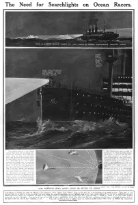
Titanic - Need for Searchlights on Ocean RacersPage from The Sphere demonstrating how searchlights on fast ocean passenger liners might have avoided the Titanic disaster. Date: 1912
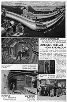
London tube made air raid proof, 1939Page from The Sphere outlining how London Underground had carried out emergency work on the under-river tube tunnels to make them waterproof from flooding during World War II
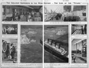
Titanic - the greatest shipwreck in the worldDouble page spread from The Sphere showing interior views of the White Star passenger liner, RMS Titanic, including the luxurious Parisian cafe, the gymnasium
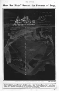
Titanic - How Ice Blink reveals the presence of bergsDiagram in The Sphere during the inquiry into the Titanic disaster showing how ice blink reveals the presence of bergs underneath the water
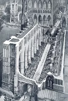
Westminster Abbey interior on wedding dayA drawing of the interior of Westminster Abbey on the occasion of the wedding of Princess Mary, only daughter of King George V and Queen Mary, to Viscount Lascelles
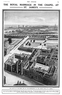
Royal Wedding 1913 - Chapel Royal, St James sThe route of the bride (Princess Alexandra, Duchess of Fife) and bridegroom (Prince Arthur of Connaught) to the Chapel Royal, St. Jamess Palace for their marriage in October 1913
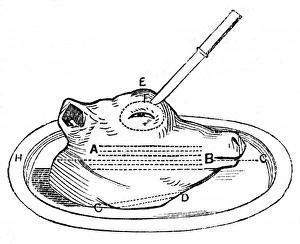
Calfs head for carvingDiagram showing how to carve a calfs head. Calfs head had many culinary uses in the Victorian kitchen, including a key ingredient in mock turtle soup
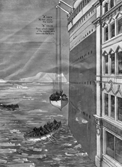
Lowering the life boatsA diagram showing life boats from the Titanic being lowered to the water. The distance is compared to the height of a city office block
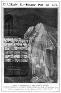
Titanic scraping icebergA diagram illustrates how the Titanic scraped past the fateful iceberg. Passengers on deck presumed that the iceberg had just been grazed with a glancing blow
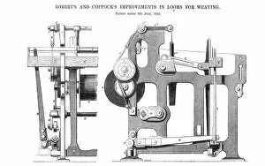
Roberts and Coppocks Improvement in Looms for WeavingTechnical drawing of an invention, patented in 1855, by Roberts and Coppock, consisting of an improved arrangement of parts for letting the yarn off the warp beam in a weaving loom
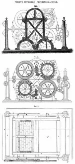
Perrys Improved Printing MachineTechnical drawing showing an invention of Mr T. J Perry of the Lozells, Birmingham and comprises a method of constructing the moveable types used in cylinder printing