Framed Print > New Images August 2021
Framed Print : Railway map, Clapham Junction area, London


![]()
Framed Photos from Mary Evans Picture Library
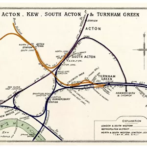
Railway map, Clapham Junction area, London
Railway map, Clapham Junction, Stewarts Lane, Lavender Hill and Longhedge, SW London, with colour coding of the various railway companies. Date: 1912
Media ID 23144176
© Mary Evans / Pharcide
Basin Battersea Chelsea Clapham Coal Depot Goods Inset Junction Junctions Lane Lavender Lines Links Maps Pier Wharf
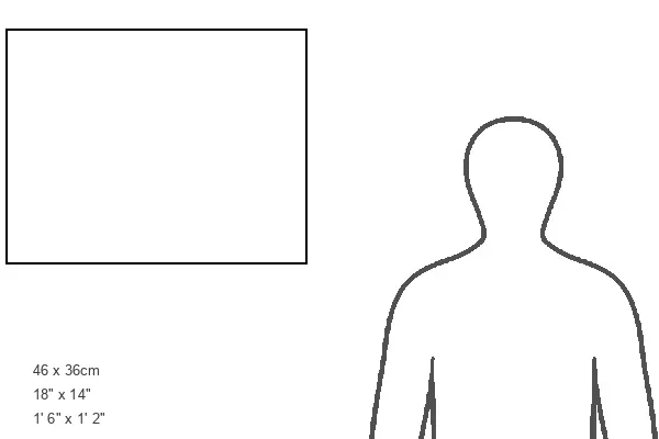
18"x14" Modern Frame
16x12 Print in an MDF Wooden Frame with 180 gsm Satin Finish Paper. Glazed using shatter proof thin plexiglass. Frame thickness is 1 inch and depth 0.75 inch. Fluted cardboard backing held with clips. Supplied ready to hang with sawtooth hanger and rubber bumpers. Spot clean with a damp cloth. Packaged foam wrapped in a card.
Contemporary Framed and Mounted Prints - Professionally Made and Ready to Hang
Estimated Image Size (if not cropped) is 40.6cm x 35.6cm (16" x 14")
Estimated Product Size is 45.7cm x 35.6cm (18" x 14")
These are individually made so all sizes are approximate
Artwork printed orientated as per the preview above, with landscape (horizontal) orientation to match the source image.
MADE IN THE USA
Safe Shipping with 30 Day Money Back Guarantee
FREE PERSONALISATION*
We are proud to offer a range of customisation features including Personalised Captions, Color Filters and Picture Zoom Tools
SECURE PAYMENTS
We happily accept a wide range of payment options so you can pay for the things you need in the way that is most convenient for you
* Options may vary by product and licensing agreement. Zoomed Pictures can be adjusted in the Cart.