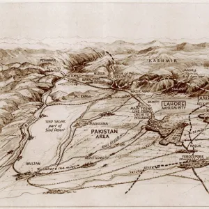
Proposed partition map of India and Pakistan

![]()
Wall Art and Photo Gifts from Mary Evans Picture Library
Proposed partition map of India and Pakistan
A map of India showing the suggested area of Pakistan - an independent state for Muslims in a free India. The shaded area shows the provinces forming the basis of Pakistan, as proposed by the Muslim League. Date: 1946
Media ID 14379766
© Illustrated London News Ltd/Mary Evans
1946 Jan16 League Muslim Pakistan Partition Proposed Suggested
MADE IN THE UK
Safe Shipping with 30 Day Money Back Guarantee
FREE PERSONALISATION*
We are proud to offer a range of customisation features including Personalised Captions, Color Filters and Picture Zoom Tools
FREE COLORIZATION SERVICE
You can choose advanced AI Colorization for this picture at no extra charge!
SECURE PAYMENTS
We happily accept a wide range of payment options so you can pay for the things you need in the way that is most convenient for you
* Options may vary by product and licensing agreement. Zoomed Pictures can be adjusted in the Basket.