Home > New Images August 2021
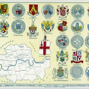
Map of the Greater London area

![]()
Wall Art and Photo Gifts from Mary Evans Picture Library
Map of the Greater London area
Map of the Greater London area with council areas marked. Date: mid-20th century
Media ID 23043928
© London Fire Brigade / Mary Evans Picture Library
Annotated Annotation Area Areas Authorities Authority Berks Buckinghamshire Bucks Council Councils Districts Essex Greater Hertfordshire Herts Maps Marked Postal Surrey
MADE IN THE UK
Safe Shipping with 30 Day Money Back Guarantee
FREE PERSONALISATION*
We are proud to offer a range of customisation features including Personalised Captions, Color Filters and Picture Zoom Tools
SECURE PAYMENTS
We happily accept a wide range of payment options so you can pay for the things you need in the way that is most convenient for you
* Options may vary by product and licensing agreement. Zoomed Pictures can be adjusted in the Basket.