Home > New Images August 2021
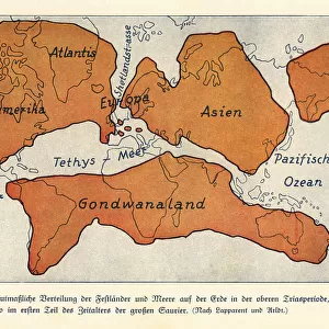
Map of the continents and seas in the Upper Carboniferous

![]()
Wall Art and Photo Gifts from Mary Evans Picture Library
Map of the continents and seas in the Upper Carboniferous
Map of the continents and seas in the Upper Carboniferous era. Atlantis, North America, Asia, European Peninsula, Gondwanaland. Colour print after an illustration from Wilhelm Bolsches Das Leben der Urwelt, Prehistoric Life, Georg Dollheimer, Leipzig, 1932
Media ID 23381454
© Florilegius
Bolsche Carboniferous Continents Creature Dinosaurs Extinct Herbivorous Hugo Leben Maage Megalosaurus Paleontology Predatory Prehistoric Prehistory Seas Urwelt Wilhelm Wolff
MADE IN THE UK
Safe Shipping with 30 Day Money Back Guarantee
FREE PERSONALISATION*
We are proud to offer a range of customisation features including Personalised Captions, Color Filters and Picture Zoom Tools
SECURE PAYMENTS
We happily accept a wide range of payment options so you can pay for the things you need in the way that is most convenient for you
* Options may vary by product and licensing agreement. Zoomed Pictures can be adjusted in the Basket.