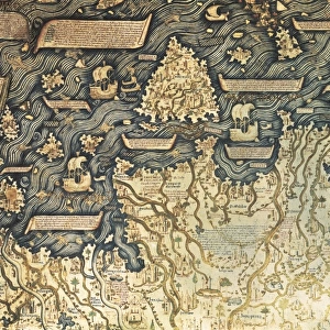
Map of YMCA shelters around London during WW1

![]()
Wall Art and Photo Gifts from Mary Evans Picture Library
Map of YMCA shelters around London during WW1
A map showing the various YMCA huts available for soldiers and sailors in the capital on leave during the First World War, though The Graphic magazine, who published this picture, note that there were far more (in 1917) than when the map was originally compiled by the Civic Survey of Greater London for the City of London National Guard, who have done great excellent work as cicerones for returning warriors. The key shows different symbols representing the type of huts available. 1 - YMCA beds, food and recreation, 2 - beds, food and recreation, 3 - rest and recreation, 4 - Dominion and Overseas Clubs, 5 - food and rest, 6 - officers clubs, 7- beds only, 8 - baths and swimming, 9 - Turkish baths, 10 - soldiers and sailors clubs, 11 - Belgian
1917
Media ID 14156328
© Mary Evans Picture Library
Accommodation Capital Civic Clubs Greater Huts Leave Maps Rest Shelters Survey Ymca
MADE IN THE UK
Safe Shipping with 30 Day Money Back Guarantee
FREE PERSONALISATION*
We are proud to offer a range of customisation features including Personalised Captions, Color Filters and Picture Zoom Tools
FREE COLORIZATION SERVICE
You can choose advanced AI Colorization for this picture at no extra charge!
SECURE PAYMENTS
We happily accept a wide range of payment options so you can pay for the things you need in the way that is most convenient for you
* Options may vary by product and licensing agreement. Zoomed Pictures can be adjusted in the Basket.