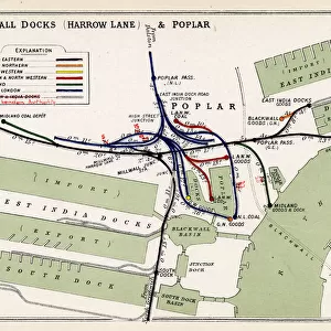
Map of Londons Docks, 1908

![]()
Wall Art and Photo Gifts from Mary Evans Picture Library
Map of Londons Docks, 1908
Illustration showing the River Thames and Londons docks in 1908, viewed with Tower of London at the bottom of the image and the East of London at the top of the image. These docks consisted of 640 acres of water, with upwards of 40 miles of quayside accomodation
Media ID 4383397
© Illustrated London News Ltd/Mary Evans
Accomodation Acres Bottom Consisted Docks Londons Miles Quay Side Upwards Viewed
MADE IN THE UK
Safe Shipping with 30 Day Money Back Guarantee
FREE PERSONALISATION*
We are proud to offer a range of customisation features including Personalised Captions, Color Filters and Picture Zoom Tools
FREE COLORIZATION SERVICE
You can choose advanced AI Colorization for this picture at no extra charge!
SECURE PAYMENTS
We happily accept a wide range of payment options so you can pay for the things you need in the way that is most convenient for you
* Options may vary by product and licensing agreement. Zoomed Pictures can be adjusted in the Basket.