
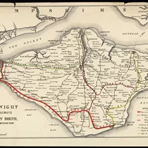
Map of the Isle of Wight

Cards
crop_landscape
extension
Mounted Prints
Home Decor
Fine Art Prints
Canvas Prints
Metal Prints
![]()
Wall Art and Photo Gifts from Mary Evans Picture Library
Map of the Isle of Wight
Map of the Isle of Wight, showing the principal roads (marked in red) and the internal Island rail network Date: 1910
Media ID 7195697
© Mary Evans / Grenville Collins Postcard Collection
MADE IN THE UK
Safe Shipping with 30 Day Money Back Guarantee
FREE PERSONALISATION*
We are proud to offer a range of customisation features including Personalised Captions, Color Filters and Picture Zoom Tools
SECURE PAYMENTS
We happily accept a wide range of payment options so you can pay for the things you need in the way that is most convenient for you
* Options may vary by product and licensing agreement. Zoomed Pictures can be adjusted in the Basket.
Beautiful Photo Prints and Gifts
Professionally Printed
Photo Prints are in stock
Professional quality finish
Made with high-grade materials
Carefully packed to aid safe arrival
Related Images

+
Shipping
+
Choices
+