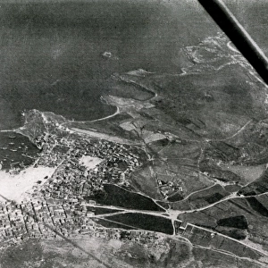
Map of the Gallipoli Peninsula

![]()
Wall Art and Photo Gifts from Mary Evans Picture Library
Map of the Gallipoli Peninsula
Map showing the distances separating the vital points in the Gallipoli Peninsula. The area held by the Allies is shown in a darker tone, and the position of the Australians at Gaba Tepe is also indicated.
1915
Media ID 14372826
© Illustrated London News Ltd/Mary Evans
Allies Dardanelles Distance Distances Gallipoli Peninsula
MADE IN THE UK
Safe Shipping with 30 Day Money Back Guarantee
FREE PERSONALISATION*
We are proud to offer a range of customisation features including Personalised Captions, Color Filters and Picture Zoom Tools
FREE COLORIZATION SERVICE
You can choose advanced AI Colorization for this picture at no extra charge!
SECURE PAYMENTS
We happily accept a wide range of payment options so you can pay for the things you need in the way that is most convenient for you
* Options may vary by product and licensing agreement. Zoomed Pictures can be adjusted in the Basket.