
Map of central London with Piccadilly Circus at centre

Photo Prints
Poster Prints
Cards
crop_landscape
Jigsaw Puzzles
Mounted Prints
Home Decor
Fine Art Prints
Canvas Prints
Metal Prints
![]()
Wall Art and Photo Gifts from Mary Evans Picture Library
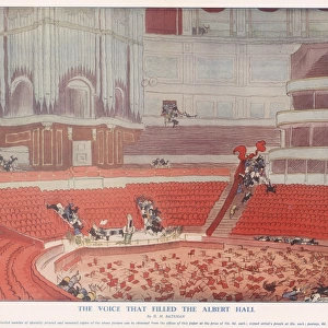
Map of central London with Piccadilly Circus at centre
A map of the West End of London with Piccadilly Circus at its centre. Famous theatres, night spots, cinemas and hotels are marked with decorative labels and symbolic drawings. Date: 1950
Media ID 14380620
© Illustrated London News Ltd/Mary Evans
Circus Maps Nightlife Piccadilly Tatler
MADE IN THE UK
Safe Shipping with 30 Day Money Back Guarantee
FREE PERSONALISATION*
We are proud to offer a range of customisation features including Personalised Captions, Color Filters and Picture Zoom Tools
SECURE PAYMENTS
We happily accept a wide range of payment options so you can pay for the things you need in the way that is most convenient for you
* Options may vary by product and licensing agreement. Zoomed Pictures can be adjusted in the Basket.
Beautiful Photo Prints and Gifts
Professionally Printed
Photo Prints are in stock
Professional quality finish
Made with high-grade materials
Carefully packed to aid safe arrival
Related Images


+
Shipping
+
Choices
+