mail_outline sales@mediastorehouse.com
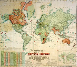
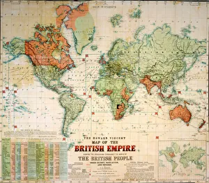
Map of the British EmpireThe Howard Vincent map of the British Empire, 1897 Date: 1897
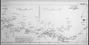
D-DAY MAP 1944Plan 1C - Operation Neptune, an elaborate map detailing the proposed D-Day Normandy assault landings by Allied troops on the French beaches. Date: June 1944
Nelson outlining his battle plans for Trafalgar, 1805This picture illustrates the famous incident when Nelson, visiting Lord Sidmouth five weeks before Trafalgar, dipped a finger in the port and sketched his plan for the expected battle
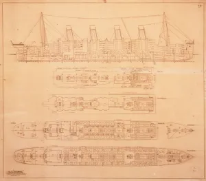
Titanic blueprintSS Titanic section and plan scale original blueprint, rubber stamped by Harland and Woolf and dated 1 May 1912. It was used in the enquiry that followed the disaster
Avebury / Stukeley MapA beautifully drawn overhead plan of the stone circles and embankment ditches at Avebury. Stukeleys accuracy is impressive, charting every stone, pasture and building
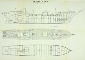
Plans of the Terra Nova shipDiagram showing the layour of the Terra Nova ship from the expedition to the Antarctic 1910-13 Date: 1910
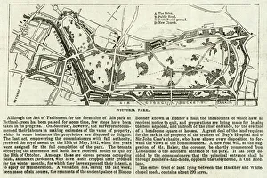
Map of Victoria ParkThe proprosed plan of Victoria Park, Bethnal Green. The entire tract of land lying between the Hackney and Whitechapel roads contains about 290 acres
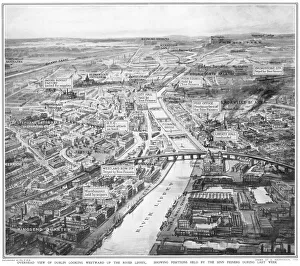
Overhead view of Dublin during the Easter RisingA birds eye view of Dublin looking westward up the River Liffey, showing positions held by the Sinn Feiners during the Easter Rising in April 1916
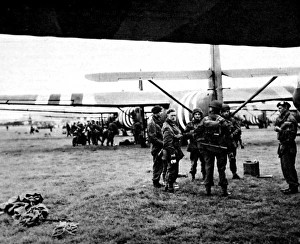
Gliders ready for Operation Market Garden Second World WarPhotograph showing gliders and men of the Allied Airborne Army, on an airfield somewhere in Britain, September 1944. On 17th September 1944 Operation Market Garden was put into action; a bold plan
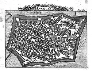
Lucca, ItalyA bird s-eye view town of Lucca in Tuscany showing the fortified walls and street plan
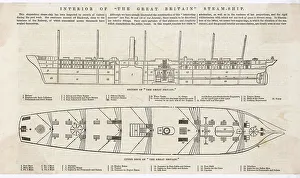
Plan of ship SS Great BritainIllustrations showing a side cutaway view and an overhead view of Brunel's steamship SS Great Britain, launched in 1843. Date: 1845
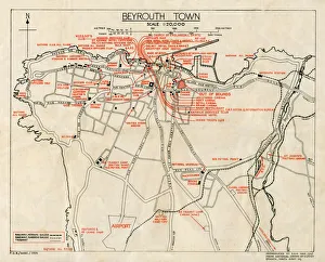
WW2 - Map of Beirut, Lebanon - with Military locationsEnd of WW2 - Map of Beirut, Lebanon showing Military locations important for a British serviceman stationed in the city at the end of the Second World War
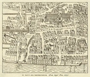
Map of St Pauls and areaMap of St. Pauls area, from Agass plan
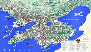
Tourist map of Bergen, NorwayTourist map (TKT - Turisttrafikkomiteen) of Bergen, Hordaland County, Norway. Date: 1951
Greyhound designDrawing 26 Vol 2 by Alfred Waterhouse for the ornamentation of the Natural History Museum, London, 1876. (Two separate negatives)
Bouncing BombPlans for Operation Chastise drawn by Sir Barnes Neville Wallis for the bouncing bomb used in the raid known as the Dambusters in World War II Date: c. 1943
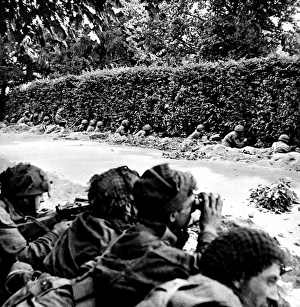
British First Airborne dug in at Arnhem; Second World War, 1Photograph showing a unit of the British First Airborne Division, in shallow trenches along a road side near Arnhem, September 1944
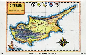
Map of Cyprus - The Island of Venus. circa 1930s
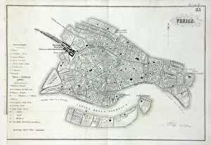
Map of VeniceMap of the city of Venice, Italy Date: 19th century
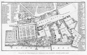
Whitehall Palace 1680A plan of the palace of Whitehall during the reign of Charles II. Date: 1680
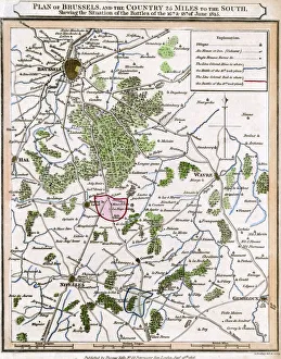
Waterloo Battle PlanPLAN OF THE BATTLE Date: 18 June 1815
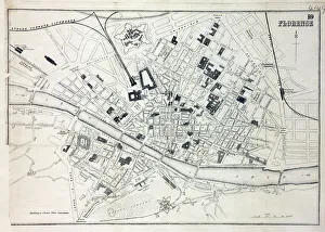
Map of FlorenceMap of the city of Florence, Italy and the River Arno Date: 19th century
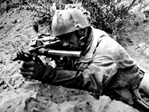
Soldier of the British First Airborne in action in Arnhem; SPhotograph showing a soldier of the British First Airborne Division firing his Sten gun at Germans near Arnhem, Holland, September 1944
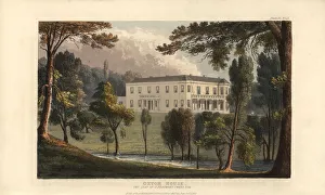
Oxton House, Devon, seat of Rev. John Beaumont Swete. Handcoloured copperplate engraving from Rudolph Ackermanns Repository of Arts, London, 1827
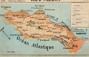
Ile d Oleron - off the French Atlantic CoastIle d Oleron - an island off the Atlantic coast of France, on the southern side of the Pertuis d Antioche strait. It is the second largest island of Metropolitan France, after Corsica
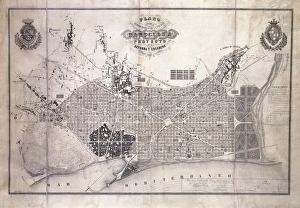
CERDA, Ildefonso (1816-1876). Spanish engineer" CERDA, Ildefonso (1816-1876). Spanish engineer and town planner. " Plan de Reforma Interior y Ensanche de la ciudad de Barcelona", urban planning of the city of Barcelona (1859)
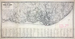
Map of LisbonMap of the city of Lisbon, Portugal 1871 Date: 1871
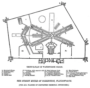
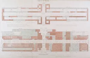
Ground plan of Wandsworth PrisonGround plan of Surrey Prison and House of Correction, Wandsworth Date: 1862
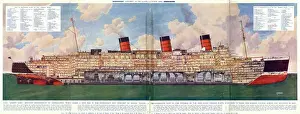
The Queen Mary linerA sectional plan of the interior of the liner Queen Mary, which operated mainly in the North Atlantic. Launched in September 1934, her maiden voyage began in May 1936
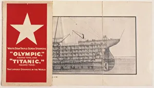
White Star Line, Olympic and TitanicA White Star Line booklet containing plans of the Olympic and Titanic triple-screw steamers. Part of a cross-section plan can be seen, revealing the various levels towards the prow of the ship
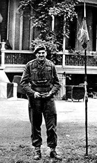
Major-General R. E. Urquhart in Arnhem; Second World War, 194Photograph showing Major-General R.E. Urquhart, Commander of the British First Airborne Division, standing outside his headquarters near Arnhem, the Hartenstein Hotel, September 1944
Crystal Palace PlanA floor plan of the Exhibition building - the ground floor and the galleries, showing how the courts open out from the central transept
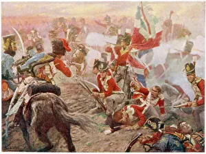
Quatre Bras / HamiltonWellington defeats Ney at QUATRE BRAS, foiling Napoleons plan to prevent the joining of the British and Prussian armies
Ballad / Twa CorbiesTHE TWA CORBIES Two crows plan to dine on the body of a new-slain knight, then o er his white banes, when they are bare, the wind sall blaw for evermair. Date: traditional
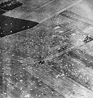
Allied Airborne Army Parachutes in Holland; Second World WarAerial photograph showing parachutes of the Allied Airborne Army floating down to earth and discarded ones, after landing, in Holland, September 1944
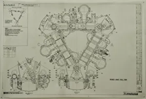
D Napier and Son - DelticGeneral arrangement of Deltic 18-11B MTB Driving End
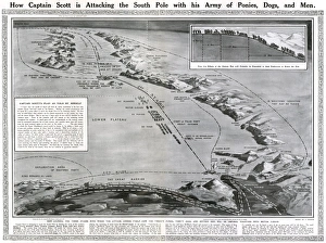
How Captain Scott is attacking the South PoleDouble page spread from The Sphere, showing a map of Antarctica along with the route of Captain Scott and his team of ponies, dogs and men in their attempt to be the first to reach the South Pole
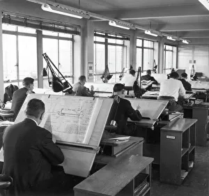
Draughtsmen at workDraughtsmen prepare technical drawings for an electronic wiring system, in a large open plan room, with plenty of essential natural light. Photograph by Heinz Zinram
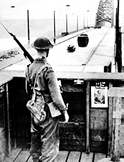
British Sentry keeping watch on Nijmegen Bridge; Second WorlPhotograph showing aan Irish Guardsman keeping watch on the Bridge at Nijmegen, September 1944. On 17th September 1944 Operation Market Garden was put into action; a bold plan devised by
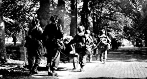
British First Airborne Troops march towards Arnhem; Second WPhotograph showing men of the British First Airborne Division marching into Arnhem with their guns and equipment, after landing outside the town, September 1944
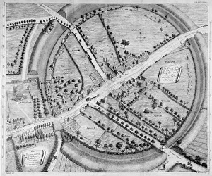
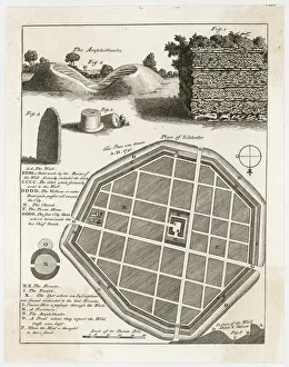
Plan of Silchester / 1777A plan and details from the well-preserved Roman town of Silchester (Calleva Atrebatum). The entire circuit of the town wall, and bowl of the amphitheatre have survived
Aubreys Plan of AveburyJohn Aubreys plan of Avebury. Aubrey was an English antiquary, who suplimented his writings on sites with detailed plans and sketches
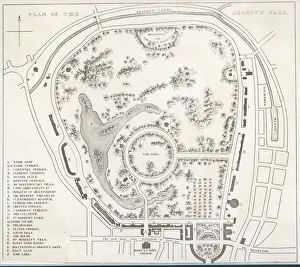
Regents Park Plan C1830A plan of Regents Park including Regents Canal and Marylebone Church Date: c1830
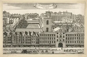
ST. BARTS / 1721 / PLANA general external view of the buildings which make up Saint Bartholomews Hospital in Smithfield, London
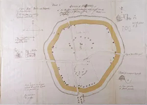
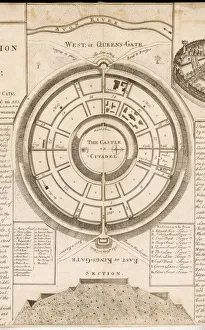
Old Sarum PlanAn exact plan and section of the castle of Old Sarum, above Salisbury Plain, showing the East or Kings Gate, the West, or Queens Gate and its proximity to the River Avon
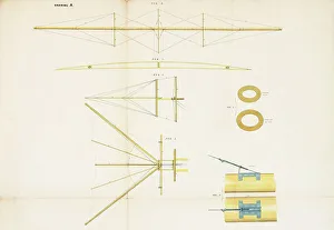
Hensons Aerial Steam CarriageThe Aerial Steam Carriage -- side view of the main frame, and plan of the controlling tail. This flying machine was patented by William Samuel Henson (1812-1888) and John Stringfellow (1799-1883)
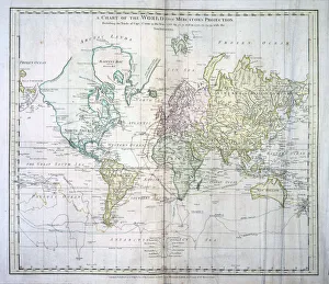
Map of the WorldThe World, showing Captain James Cooks voyages from 1768 - 1775, based on Mercators Projection, published by William Faden 1778 Date: 1778