mail_outline sales@mediastorehouse.com
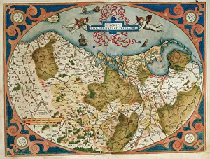
Map of Germany and current Netherlands. Theatrum Orbis Terrarum by Abraham Ortelius (1527-1598). First Edition. Antwerp, 1574. Library of Catalonia. Barcelona. Spain
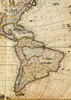
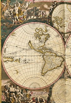
Map of America. Nova Totius Americae Descriptio by FrederikNova Totius Americae Descriptio. Map of America. By Frederik de Wit (1630-1706). Amsterdam, 1666
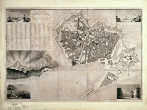
Barcelona (19th c. ). Geometrical map, by Jos項Barcelona (19th c.). Geometrical map, by Jos頍 as y Vila. SPAIN. Barcelona. Historical Archive of Barcelona
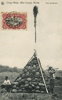
Trigonometry PointA Trigonometry Point at Buvita in the Belgium Congo, topped off with a broom!
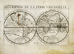
Description de la Terre Universelle (1667). Map. Engraving
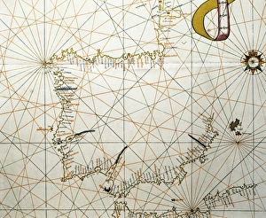
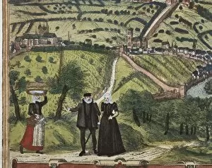
Portolan Atlas, 1587. Map of the Iberian Peninsula, the north coastline of Africa and the Vasque Countrys region in France. Made in Messina. Facsimile. Miniature Painting. SPAIN. Madrid
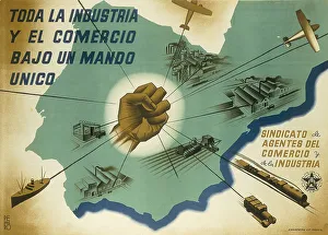
Spanish Civil War (1936-1939). Toda la industria y el comercio bajo un mando unico (All the industry and trade under an only rule)
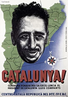
Spain (20th c. ). Civil War. Catalunya! (Catalonia!)Spain (20th c.). Civil War. Catalunya! (Catalonia!). Poster by Ricard Giralt Miracle with the portrait of Lluis Companys. SPAIN. Salamanca. Archivo Historico Nacional
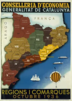
Spanish Civil War Map Of Catalonia Regions Andspanish, civil, war, map, of, catalonia, regions, and, counties, october, poster, edited, by, the, regional, ministry, ecocomy, generalitat, spain, barcelona, biblioteca, de, catalunya, national
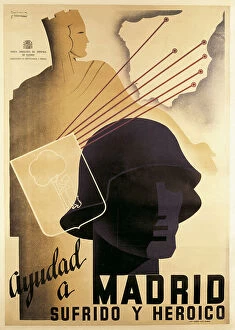
Spainish Civil War (1936-1939). Ayudad a Madrid sufrido y heroico (Help the suffering and heroic Madrid). Poster by Cabana y Contreras. SPAIN. Barcelona
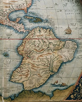
Map of Central and South America. Theatrum Orbis Terrarum by Abraham Ortelius (1527-1598). First Edition. Antwerp, 1574
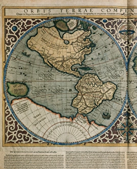
World Map by Rumold Mercator (1512-1594)Orbis Terrae Compendiosa Descriptio. World map, 1587. Detail of America. By Rumold Mercator (1545-1599)
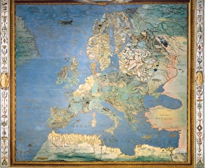
ITALY. Caprarola. Villa Farnese. Map of Europe. 1574 painting by Giovanni Antonio da Varese Vanosino. Stanza del Mappamondo (Geographic room or Room of the World Map). Renaissance art. Cinquecento
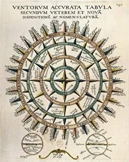
Tabula secundum accurata Ventorum veterem et nova [m] dispositione [m] ac nomenclature [m] (Table of the winds according to the old and new layout and nomenclature)
Theatrum Orbis Terrarum by Abraham Ortelius (1527-1598)Map of America. Theatrum Orbis Terrarum by Abraham Ortelius (1527-1598). First Edition. Antwerp, 1574
The Invincible Armada. Map of Robert Adams. Engraving" The Invincible Armada. Map of Robert Adams. Engraving by Augustine Ryther in " Expeditions in Anglian, Vera Descriptio" (1588). SPAIN. San Lorenzo de El Escorial
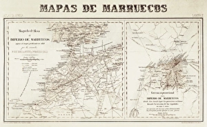
Spain. War of Africa (1859-1860). Maps of Morocco
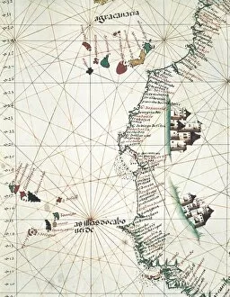
Map of the West of African coast with the Islands of Macaronesia, the Canary Isles and Cape Verde. 1514. Miniature Painting. PORTUGAL. Lisbon. Maritime Museum
Spain. First Carlist War (1836). Map of Spain
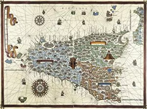
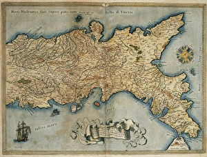
Chart by Joan Martines. Island of Sicily (1591). Miniature Painting
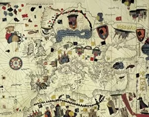
Portolan chart of the Mediterranean sea (1439) of Gabriel de Vallseca. It belonged to Amerigo Vespucci. SPAIN. Barcelona. Barcelona Maritime Museum
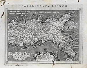
Map of the Kingdom of Naples. Theatrum Orbis Terrarum by Abraham Ortelius (1527-1598). First Edition. Antwerp, 1574. Library of Catalonia. Barcelona. Spain
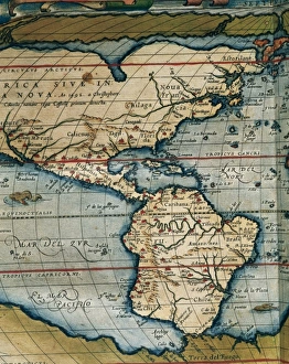
Nova Orbis Tabula in Lucem Edita by Frederik de Wit (1630-1706). 17th century. Detail of the Americas, Pacific Ocean and islands discovered. Amsterdam
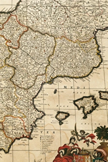
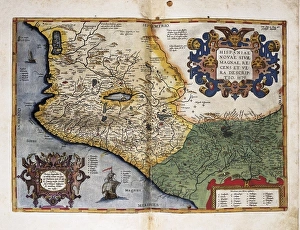
Spain. Detail. Atlas by Frederik de Wit (1630-1706). 17th ceMap of the Principality of Catalonia, Kingdoms of Navarre, Aragon, Valencia, Murcia and the Balearic Islands. Atlas by Frederik de Wit (1630-1706). Amsterdam, 17th century
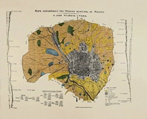
VILANOVA i PIERA, Joan (1821-1893). Agronomic map of Madrid municipal area. SPAIN. MADRID (AUTONOMOUS COMMUNITY). Madrid. Instituto Geol o y Minero de Espa
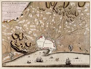
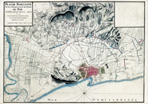
French map of the city of Barcelona (1706). SPAIN. CATALONIA. Barcelona. Barcelona City History Museum
Map of the Kingdom of Naples. 1597-1568. Illustration from the work Geografia, cio鬠 Descrittione universale de la terra, edited in Venice by Giovanni Battista and Giorgio Galignani. SPAIN
Theatrum Orbis Terrarum. New Spain (Mexico)ORTELIUS, Abraham (1527-1598). Theatrum Orbis Terrarum. 1570. It is considered to be the first modern atlas. Map of New Spain (Mexico), 1579. Printed in Antwerp by Christophe Plantin (1588). Etching
Portrait of Magalhaes. Spanish anonymousMAGELLAND, Ferdinand (1480-1521). Portuguese navigator and discoverer. Oil on canvas
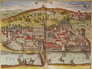
Civitatis Orbis Terrarum. Przemy?lBRAUN, George (1541-1622). Civitatis Orbis Terrarum (Theatrum orbis terrarum). 1572-1617. Przensyl, Polish city near the border with Lithuania. Etching. FRANCE. Ό E-DE-FRANCE. Paris
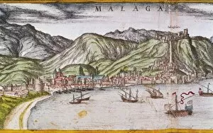
Civitatis Orbis Terrarum. MalagaBRAUN, George (1541-1622). Civitatis Orbis Terrarum (Theatrum orbis terrarum). 1572-1617. Malaga (1599). Etching. SPAIN. CATALONIA. Barcelona. Historical Archive of Barcelona
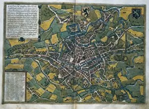
Civitatis Orbis Terrarum. GhentBRAUN, George (1541-1622). Civitatis Orbis Terrarum (Theatrum orbis terrarum). 1572-1617. Ghent (1572). Etching. SPAIN. CASTILE AND LEON. Salamanca. Salamanca University Library
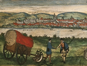
Civitatis Orbis Terrarum. EcijaBRAUN, George (1541-1622). Civitatis Orbis Terrarum (Theatrum orbis terrarum). 1572-1617. Ecija (1567). Etching. SPAIN. CASTILE AND LEON. Salamanca. Salamanca University Library
Civitatis Orbis Terrarum. LondonBRAUN, George (1541-1622). Civitatis Orbis Terrarum (Theatrum orbis terrarum). 1572-1617. London. Detail. Etching. SPAIN. CASTILE AND LEON. Salamanca. Salamanca University Library
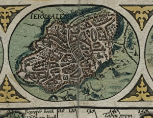
Atlas Novus. Asia, 17th c JerusalemBLAEU, Jan (1596-1673). Atlas Novus or Atlas Maior. 1635 - 1665. Asia noviter delineata. Map of Asia printed in Amsterdam ca. 1635. Detail with view of the city of Jerusalem. Etching. SPAIN
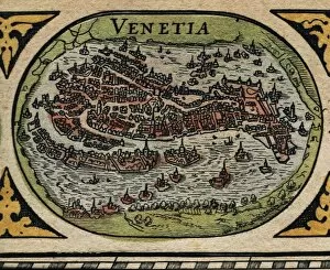
Atlas Novus. Europe, 17th c VeniceBLAEU, Jan (1596-1673). Atlas Novus or Atlas Maior. 1635 - 1665. Europa recens descripta. Map of Europe printed in Amsterdam ca. 1633. Detail of the city of Venice. Etching. SPAIN. CATALONIA
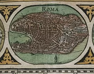
Atlas Novus. Europe, 17th c RomeBLAEU, Jan (1596-1673). Atlas Novus or Atlas Maior. 1635 - 1665. Europa recens descripta. Map of Europe printed in Amsterdam ca. 1633. Detail of the city of Rome. Etching. SPAIN. CATALONIA
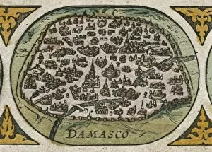
Atlas Novus. Asia, 17th c DamascusBLAEU, Jan (1596-1673). Atlas Novus or Atlas Maior. 1635 - 1665. Asia noviter delineata. Map of Asia printed in Amsterdam ca. 1635. Detail with view of the city of Damasco. Etching. SPAIN. CATALONIA
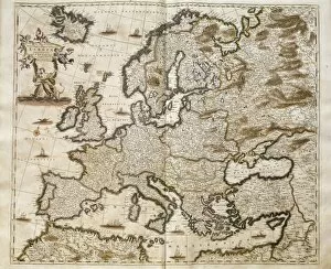
Map of Europe of Frederick de Wit (Amsterdam, 17th c.). Engraving
World map by Joan Martines (1591). Miniature Painting
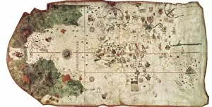
COSA, Juan de la (1460-1510). Cartographer. Nautical chart. 1500. Detail. SPAIN. Madrid. Navy Museum
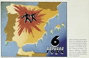
Spain. Second Republic (1931-1936). 6th October
Chart by Juan de la Cosa (1500). SPAIN. Madrid. Navy Museum
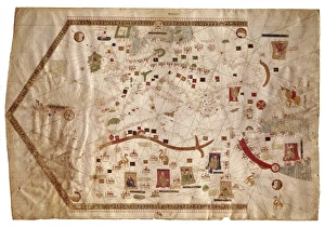
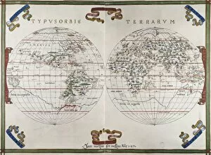
Portolan chart atlas, 1591. World map. Renaissance
Spain (1713). War of the Spanish Succession. Siege of Barcelona. French map with the position of the Louis XIVs troops
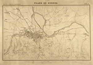
Map of Gerona (1809). SPAIN. Madrid. National Library
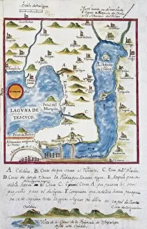
Map of the archbishopric of Mexico (1767), by Jos頁 ntonio Alzate. View of the area of Tenochtitlan, the lagoons of Chalco and Tescuco. From the Lorenzana-Borb ollection. SPAIN. Toledo
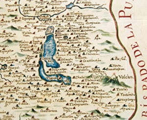
Plan of the archbishopric of Mexico: Mexico City and his lagoon. 1767. Collection Lorenzana-Borb Miniature Painting. SPAIN. Toledo. State Public Library