mail_outline sales@mediastorehouse.com
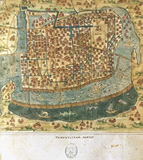
Map of Tenochtitlan. Mexico, 1560. By Alonso de Santa CruzMap of Tenochtitlan. Mexico, 1560. General islario of all the islands in the world. Work of the chronicler and cosmographer Alonso de Santa Cruz (1505-1567). National Library. Madrid. Spain
Map of Greek island of Corfu. Ionian Sea. Italian map. 1537
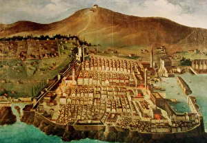
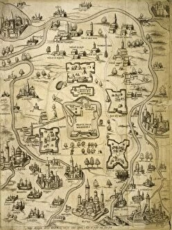
Dubrovnik. Map of the city before the earthquake of 1667. Croatia
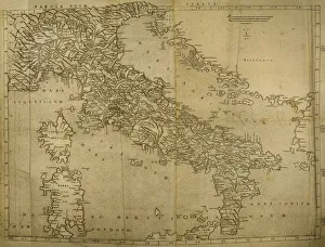
Map of Italian Peninsula, Islands of Corsica and Sardinia and Adriatic coast. Engraving. 16th century
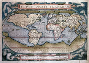
Theatrum Orbis Terrarum (Theatre of the World) by Abraham OrTheatrum Orbis Terrarum (Theatre of the World). Is considered to be the first true modern atlas. Written by Abraham Ortelius and originally printed on May 20, 1570, in Antwerp. World Map
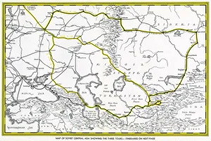
Map of Soviet Central Asia - showing marked tour routes. Date: 1933
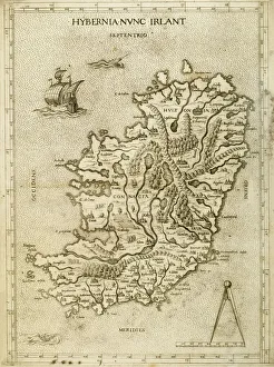
Hybernia Nunc Irlant. Ireland. Map was clearly made by a member of the Lafreri School of cartographers, Antonio Lafreri (1512-77). Rome, 1570. Renaissance. Engraving by Paolo Forlani, 16th C
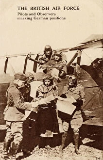
WW1 - Royal Air Force - Pilots and Observers mark targetsWW1 - Royal Air Force - Pilots and Observers mark enemy german targets and positions. Date: circa 1918
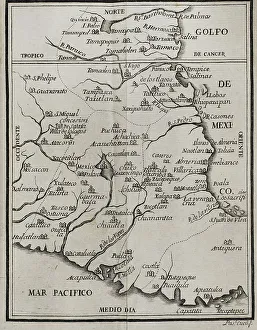
Map of the territory of New Spain. Historia de la Conquista de Mexico, poblacion, y progresos de la America septentrional, conocida por el nombre de Nueva Espana (History of the Conquest of Mexico)
Jungfraujoch railway routeThe railway route of the Jungfraujoch in Edwardian Switzerland. The making of the Jungfraujoch railway. The Jungfraujoch is a saddle connecting two major 4000ers of the Bernese Alps
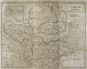
European Turkey map by Th. DuvotenayEuropean Turkey map by Thunot Duvotenay. Historia de Turquia by Joseph Marie Jouannin (1783-1844) and Jules Van Gaver, 1840. Date: 2018
Beechcraft AT-11 Kansan ZK-AHO (msn 3691, ex 42-37208), of Aerial Mapping Ltd. at Whenuapai, NZ, on 1 October 1961. Date: 1961
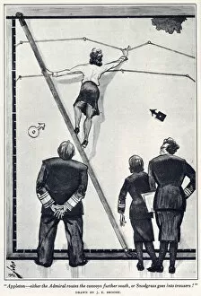
"Appleton - either the Admiral routes the convoys further south" Appleton - either the Admiral routes the convoys further south, or Snodgrass goes into trousers." A young woman in a naval operations room reveals her stockings while perching on a ladder
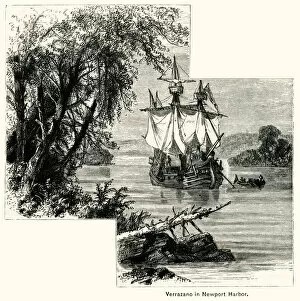
Verrazzano at Newport HarbourGiovanni da Verrazzano, Italian explorer, arriving in 1524 at Newport Harbour, Rhode Island. This was part of his first American expedition mapping and exploring the North American coast for Italy
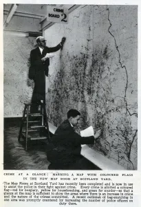
New Map Room at Scotland YardMarking a map with coloured flags in the new Map Room at Scotland Yard, 1947. Each flag represents a crime(yellow for housebreaking, red for burglary, green for murder)
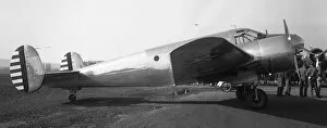
Beechcraft F-2-BHUnited States Army Air Corps - Beechcraft F-2-BH. (The 14 F-2s were given the msn 340 to 353 and serial numbers 40-682 to 40-695)
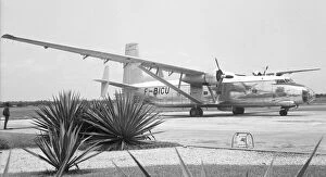
Hurel-Dubois HD. 34 F-BICUHurel-Dubois HD.34 F-BICU, of the Institut Geographique Nationale (IGN), the French government photo-surveying and mapping agency, somewhere in Africa, probably Cote d Ivoire or Senegal
Overlapping Vertical Photographs of a Town Aerial-Photog?Overlapping Vertical Photographs of a Town Aerial-Photography
Overlapping Vertical Images of Westbury Aerial-Photograp?Overlapping Vertical Images of Westbury Aerial-Photography by RAF No1 Photographic Section 28 Wing RAF Yatesbury Date: 1918
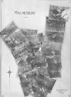
Overlapping Vertical Images of Malmsbury Aerial-Photogra?Overlapping Vertical Images of Malmsbury Aerial-Photography by RAF No1 Photographic Section 28 Wing RAF Yatesbury Date: 1918
Italy. Cities of Mantua, Bologna, Venice, Modena, Ferrara and Parma. Italian engraving. Map. 16th century
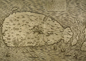
Map of Malta. Island. Mediterranean Sea. Italian engraving. 16th century
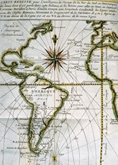
Map of the Atlantic Ocean. 18th centuryMap of the Atlantic Ocean from Newfoundland to Cape Horn. At A Voyage to the South-sea and along the coasts of Chili and Peru, in the years 1712, 1713 and 1714 by Amedee-Franc
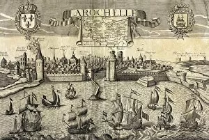
La Rochelle. Map of the city on the Atlantic. 16th centuryLa Rochelle. Map of the city on the Atlantic. Sixteenth-century engraving by Jollain
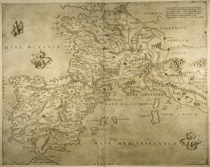
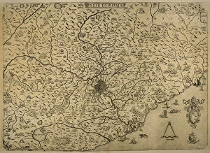
Iberian Peninsula, France and northern Italy. 16th century. Italian map
Map of the British Isles. 16th century. 1543
Map of the cities of North Africa. 16th century
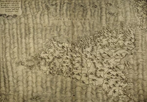
Map of Sicily. Mediterranean Sea. By Giacomo Gaftaldo Piermon. Italian engraving, 1545
Map of city of Rome. Italian engraving. 16th century
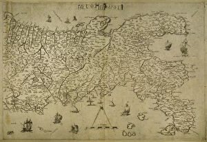
Map Kingdom of Naples. Southerm of Italian Peninsula. Italian engraving. 16th century
Friesland. Map of North of Netherlands. Made by Michaelis Tramezini, 1558. Printed by Iacobus Bossius
Map of Friesland. Netherlands. Made by Michaelis Tramezini, 1558. Printed by Iacobus Bossius
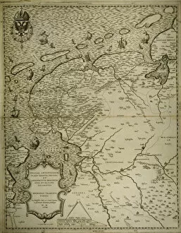
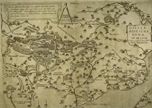
Map of Belgium, France and Luxembourg. Made by Michaelis Tramezini, 1558. Printed by Iacobus Bossius
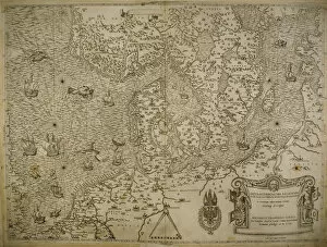
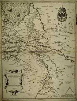
Holland, Belgium and part of Germany. Map. Made by Michaelis Tramezini, 1558. Printed by Iacobus Bossius
Cristobal de Olid (1488-1524). Spanish conqueror. Colored engraving, 1726. Library University of Barcelona. Spain
Demostratio Artis Geometricae Ex Multis Voluminibus Digestum. Schematic map of the Iberian Peninsula. 11th century. Depicts the Iberian Peninsula in a pentagon invested
Capture of Calais from the English in 1558 by Francis de Lorraine, Duke of Guise, (january 1558) which had been under English rule for two centuries
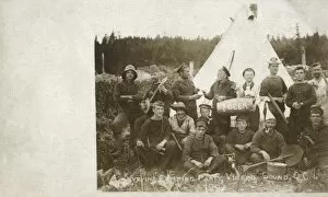
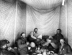
Sailors camping party, Virago Sound, CanadaSailors camping party, Virago Sound, Graham Island, Queen Charlotte Islands, British Columbia, Canada. They belong to HMS Egeria, a British Royal Navy coastal survey ship. Date: 1907
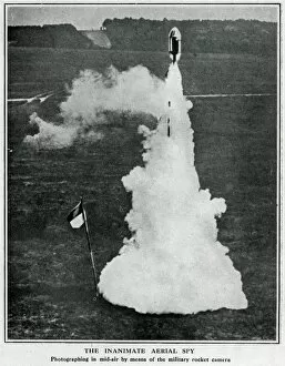
German military rocket camera, WW1A German military rocket camera with a Zeiss lens being fired into the air in the early weeks of the First World War. It was designed to map enemy territory to facilitate invasion
Map of the Moon Date: circa 1900
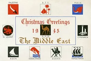
Christmas Postcard from the 512 Field Survey Company, M.E.F. (Middle Eastern Force) - serving The Middle East. The badges/flags of the regions/areas covered by (and in alliance with) the Co
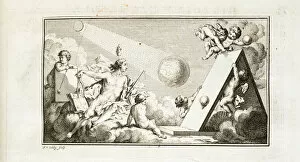
Mapping eclipse / heavenly bodies, trigonometry. Engraving by J. vander Schley, from Pierre de Hondt, Histoire Naturelle generale et particuliere avec la description du Cabinet du Roy.Header to
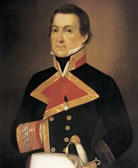
Alessandro MalaspinaSpanish naval officer and explorer. Commissioned by the Spanish government, from 1789 to 1794 he and Jose de Bustamante y Guerra carried out a scientific expedition throughout the Pacific
Herbert Kitchener and others in Western PalestineHerbert Kitchener (later Lord Kitchener, 1850-1916) and others inside their tent whilst on a mapping survey of Western Palestine (Israel, West Bank and Gaza today) for the Palestine Exploration Fund